Bear Box at Hidden Falls Campground (HP09)
Generated on 20 Oct 2025 - see revision history - please send updates to the webmaster
Detail Map of waypoint HP09
in Hockett Plateau:
(scroll down for directions, waypoints, and area map)
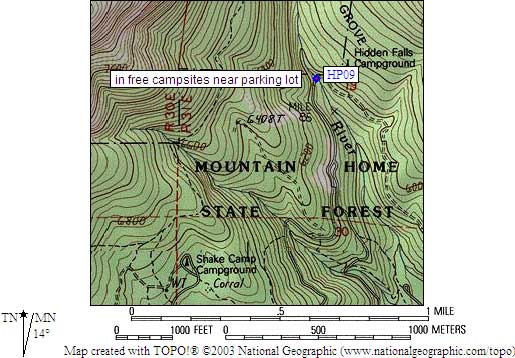
- HP09 is 6 large boxes with no latches, at about 6000 feet,
in the GPS route HOCKETT PLATEAU.
- Directions from Steve Eckert, with GPS waypoint, June 2001:
The Hidden Falls Campground is the trailhead for the River Trail,
which goes up the Tule River to the Hockett Plateau. This trail is
shorter than the West Side Trail from Shake Camp, and the campground
is more developed. Six large boxes are at the campsites, and they
have provisions for padlocks but no latching clips. We saw unlocked
boxes with food inside and no apparent bear or rodent problems.
- HP09 coordinates: (see GPX waypoint download links above)
  (lat,lon) = (36.2584000, -118.6633500) in decimal degrees, NAD83.
  (zone,east,north) = (11S, 350648.0, 4013697.0) in decimal meters, NAD27.
- Scroll down for a regional map of the entire Hockett Plateau region.

Map exported from TOPO! software, used with permission.
Useful Links: