Towne Point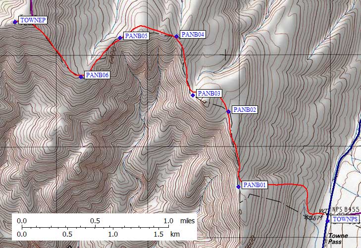
|
I drove into weather, and spent the night in my car at Towne Pass.
It was snowing hard when I arrived, but there wasn't much accumulation
with the strong wind and consistent blowing snow. No one bothered me,
but camping at the pass is probably not legal. A ranger later said
the dirt road to Panamint Butte is inside the park but legal to camp
on if you are at least 2 miles from pavement.
There is a short and obscure dirt road leading from the Towne Pass parking area (waypoint TOWNPS). From the end of that road, get on a ramp that ascends to the right toward a wash. Stay left of the wash to the ridge, then go right and basically follow the ridge to the top of Towne Point (waypoint TOWNEP, 7287'). |
Towne Point with fresh snow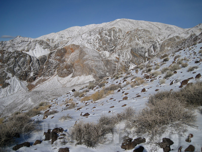
Towne Point is volcanic rock, and its "best" feature is a view of the Sierra including Whitney. Other than that it's a stairmaster walk-up usually done on the way to the lower elevation DPS peak Panamint Butte. It took about 3 hours to climb in the fresh snow, and an hour to descend. In that short time, most of the snow had melted off. The wind was still fierce, so I dropped east to the Emigrant campground (EMIGCG) where teenagers ernestly discussed life all night and middle aged women idled their diesel engines to stay warm while sleeping in their pickup cabs. It was not peaceful. | |
Pinto Peak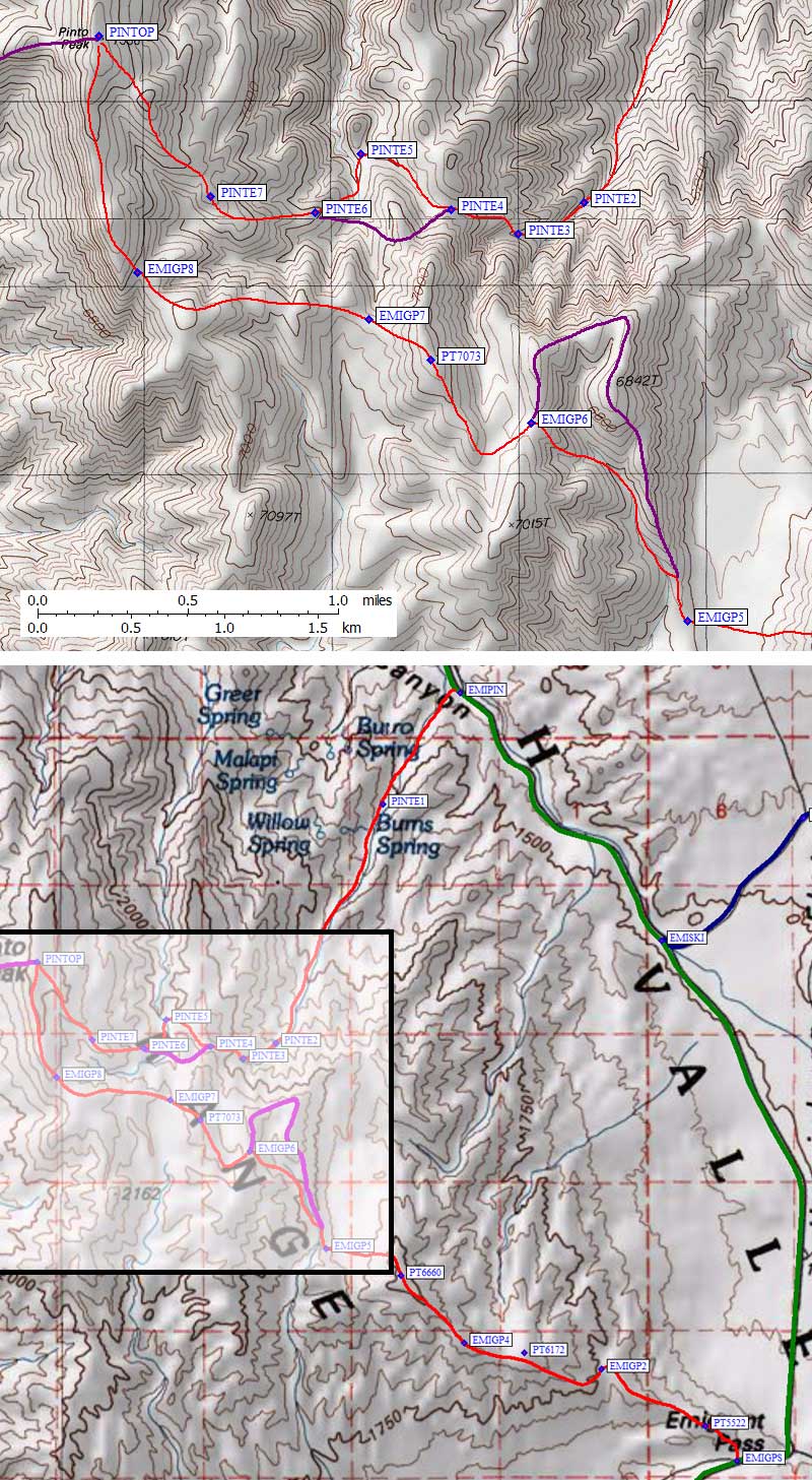
|
There are three approaches to this peak that I know of, and I did two of them.
The shortest is from Towne Pass, but that would be the same windy view
I had the day before (see below for Daryn's description of that route).
The longest is from Emigrant Pass, but it's on a ridge
the whole way and I didn't want wind again. I think the most scenic route is
up an un-named drainage from Emigrant Canyon. See the
trailhead page
for driving waypoints and trailheads for all three approaches.
Just after dawn, I parked at waypoint EMIPIN, which I had scouted the day before. There is no road sign, but the right place to park is marked by a mound of dirt and a wilderness stake. This former road is closed and almost overgrown, but still worth finding to avoid the light scrub brush. From the parking area (only large enough for 2-3 cars) the road goes north and then turns east into the drainage. It's really easy walking up to the old mine near Burns Spring (which features several old passenger cars and a shack near waypoint PINTE1). At waypoint PINTE2 I took the right fork of the wash at large orange-brown cleaver. Any time after than you can climb onto the rib right (north) of the drainage to avoid the steepening bowl where wash ends. Traverse between two saddles (PINTE4-5) and pick any route over open terrain to Pinto Peak (waypoint PINTOP, 7508'). It took me about 4 hours to summit, 4.9 miles from the car. | |
Tucki isn't very high but it's very wide (as seen from Pinto Peak)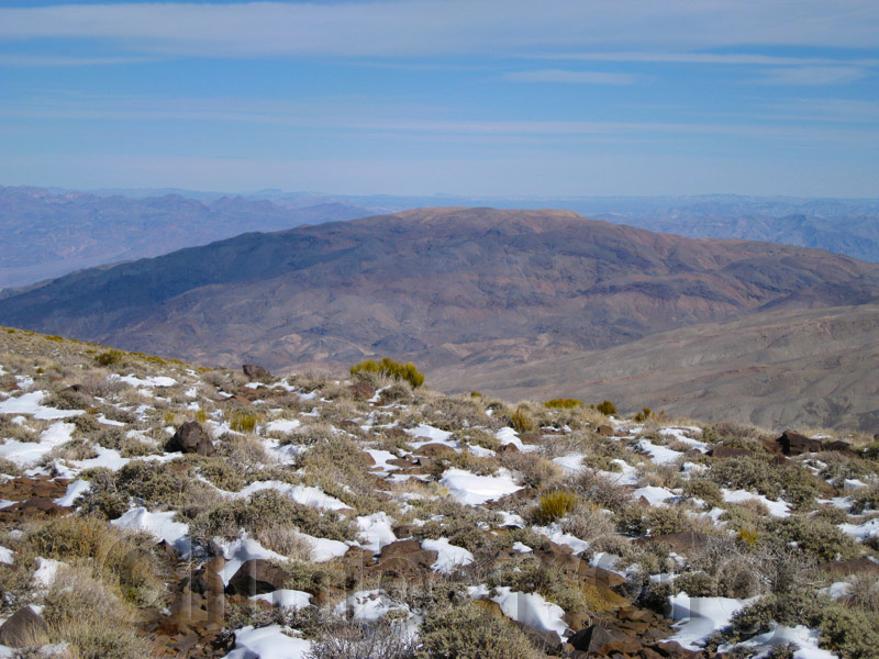
Imagine my surprise when I found a jeep trail at the summit of Pinto! It is faint in places, but I followed it all the way down to Emigrant Pass. One major deviation from the old road is at waypoint EMIGP6, where I cut down an easy slope while the road went around the drainage and came down a rib. The walking is easy, and there's no real route finding, but it's 6.8 mi from the peak to the pass. Then I walked another 6.3 miles back to the car on pavement. There was plenty of traffic on the highway, but no one stopped and it only took a couple of mostly downhill hours.
This night was worse at Emigrant Campground, with a ranger coming to check out an illegal fire, 4 cars and 4 tents per site, and an electric guitar starting up at 9pm! My mistake, coming here on a holiday weekend when GenX hippies were reuniting their outer selves. The next day I scouted Mosaic and drove to Skidoo, but first I had to drive all the way to Furnace Creek for premium gas (Stovepipe has only regular, and my car's computer will rat me out to the dealer if I use low octane). After all the wind and snow, Furnace Creek had very nice weather! I enjoyed a shower and long lunch with a cold beer under a shade tree. On the way to Skidoo, however, the sky went gray and the temperature dropped. It looked like rain. The road to Skidoo is well marked, and suitable for all vehicles. I noted the "Day Use Only" sign when I left the pavement (at EMISKI), and followed my GPS to the sign marking the old site of Skidoo. There is a road junction and turnaround loop at the sign, but it's a long walk back to the "Wilderness Area" sign blocking the old side road toward Tucki (waypoing SKIDTH). There is no wide spot, no parking, and graded berms on both sides. Look for the roadblock with a sign that says "Wilderness Restoration, foot and horse traffic only". I put two wheels up on the berm and hoped no yahoos would crash into my car. Then I put up a tent on the nice flat gravel and hoped no one really cared about crashing for the night (as opposed to developing a campsite). Matt, Anne, and Jen showed up in his Rav4 around 10pm, following a GPS waypoint I had sent them from my sat phone. 4am came early, Jen was far away, and Matt and Anne spent a cold night in the vehicle due to forgotten sleeping bags... but we all piled in my car and raced around to Mosaic Canyon in time for a pre-dawn start. | ||
Tucki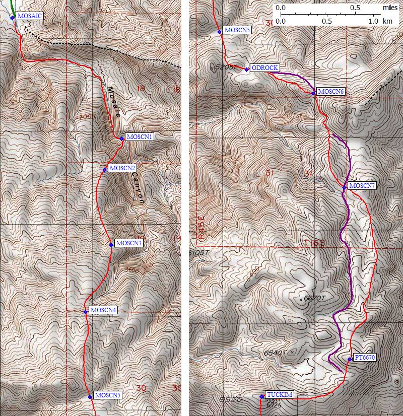
|
Mosaic Canyon also says Day Use Only, but my car was there before dawn and after dark and didn't get a ticket. Maybe it's OK for a car to be there as long as no one is in it?? We crunched up the gravel of the wash for about a mile, then turned up the right side where Matt and Anne had found a use trail. This trail bypasses the lower waterfall, but if you keep going up where it levels off you can easily escape the canyon walls. Less than 1000' up the route levels off and the rest of the day is pretty mellow. Nice views back into the canyon and out into Death Valley, no clouds, not too much wind.
Matt has a trip report with lots of pictures
on his website (you must enable cookies): |
Easy ridge walk near the odd rocks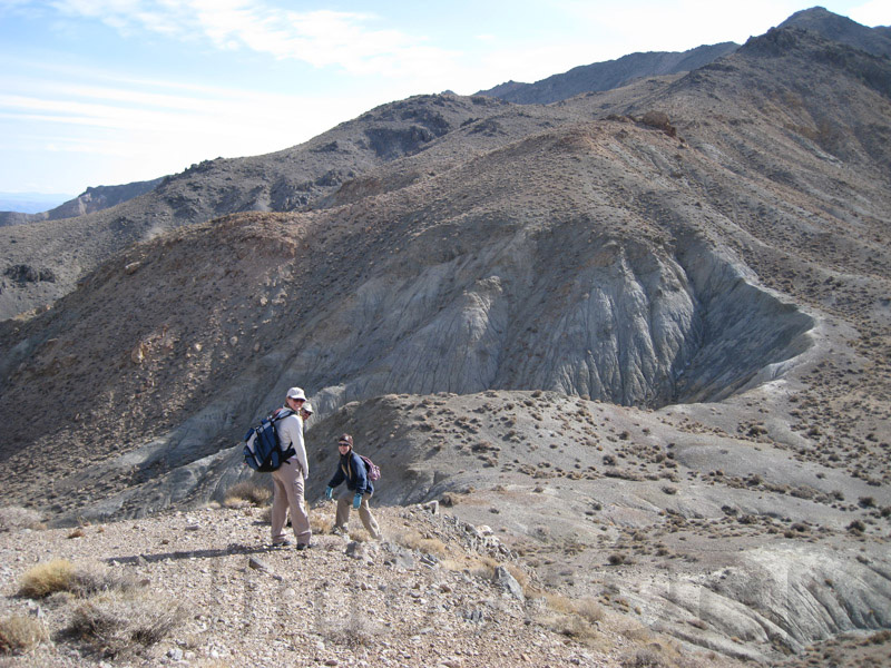
By 3.6k (near MOSCN3) we were following the edge of a deep erosion gully, which we went around at MOSCN4. On the map this is confused terrain, but on foot it seemed like the route was obvious. Going the other direction might be tricky. We bypassed twin bumps (Point 5205) and found some shiny rocks, then debated whether to climb or traverse around the next (bigger) bump. A use (or game) trail cuts across the steep loose face, so Matt reluctantly agreed to forego the extra gain and traverse (from waypoint MOSCN6). From there we followed the ridgeline to the summit. There was minor up and down, but the steadier gain of staying in the drainage next to this ridge would have been balanced by sandy footing and lesser views. | |
Death Reset == Tucki Mountain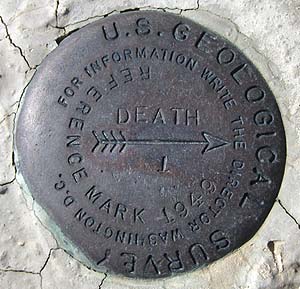
|
According to register, Tucki Mtn (waypoint TUCKIM, 6726') was first
called "Death Reset", and the BM is labelled just "Death". The name
Tucki does not appear on the 7.5' USGS quad, so it's not clear how
or when it got that name. Anne had cupcakes for Matt's birthday,
and we soaked in the sun for quite a while. Eventually reality set
in and we decided that since there was quite a bit of climbing to
do (not just descending) between the peak and Skidoo we should get started.
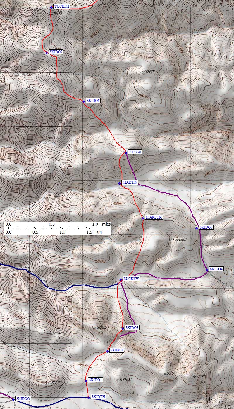
We meandered down the ridge south and southeast from Tucki (waypoints SKIDO6-7), dropped through a draw and climbed Point 5730, then dropped steeply to the old Martin Crossing cabin (waypoint MARTIN), which is a tiny rat-infested shack with a surprising amount of stuff left in it. The road it is near might be drivable from the west, so please let me know if you've been on it. |
|
The shack was a small detour, and worth it, but now we had to climb
the ridge on the other side of the valley. No way Matt was going to
follow the DPS Guide and go around. Up 300', down, slightly up, more down
and we were crossing another part of the same road in Lucky Wash
(waypoint LUCKYW). In the late afternoon it seemed like a lot of
work going up and down, but it cut off over a mile of walking and
cost only 200' of gain. One more big climb (900') to go and once again
we thought the DPS Guide suggestion to walk up a drainage was
not as good as doing the ridge next to it (over waypoint SKIDO3).
Finally, easier walking! It was getting dark, so I'm not sure if we could have gotten back on the old road sooner, but the road which is blocked by a wilderness sign at the near-Skidoo DPS trailhead joined us from the west (somewhere near SKIDO2) and led us back to the car. Headlamps were not quite needed, which made Matt sad. We really should have done those extra bumps and spent more time on the summit! We quickly eroded Anne's Vertical-Limit-Themed birthday cake for Matt and drove back around to Mosaic Canyon. They took off for an all-night dash home, I cleaned up and changed clothes and drew the attention of a ranger who drove up from Stovepipe to see why there were lights at a day-use-only trailhead. He seemed skeptical that we had actually walked from there to Skidoo but not upset as long as I was leaving. Now. |
| I've wanted to do this Tucki Traverse since the 80s, but never got around to it so I was excited when Matt set it up. We did it in good style and good spirits! It was about 12 miles total, with 6.1k gain from Mosaic to the top and 1.7k gain on the way DOWN to Skidoo. The maps above are broken into the southern and northern half of the traverse, in case you don't want to do the one-way trip. Try out the Google Earth view on the interactive map link below, which just draws straight lines between the waypoints, if you want to fly rather than climb. | |
![]() Download the Waypoint+ data below as a GPX file for your GPS.
Download the Waypoint+ data below as a GPX file for your GPS.
Datum,North America 1983,GRS 80,0,-1.6E-7,0,0,0
RouteName,9 ,PANAMINT TOWNE POINT
RoutePoint,D,TOWNPS, 36.4001564980,-117.2799781561,01/30/2010,02:26:42,TOWNE PASS 5000
RoutePoint,D,PANB01, 36.4034899473,-117.2908799648,01/30/2010,02:27:03,
RoutePoint,D,PANB02, 36.4109300375,-117.2920900583,01/30/2010,02:27:24,
RoutePoint,D,PANB03, 36.4125599861,-117.2964199781,01/30/2010,02:27:41,
RoutePoint,D,PANB04, 36.4183900356,-117.2984700203,01/30/2010,02:27:52,
RoutePoint,D,PANB05, 36.4182100296,-117.3053400517,01/30/2010,02:28:21,
RoutePoint,D,PANB06, 36.4143400192,-117.3100999594,01/30/2010,02:28:27,
RoutePoint,D,TOWNEP, 36.4197900295,-117.3181699514,01/30/2010,02:28:35,TOWNE PT 7287
RoutePoint,D,PANB08, 36.4257999659,-117.3164800406,01/30/2010,02:29:07,
RoutePoint,D,PANB09, 36.4325499535,-117.3164000511,01/30/2010,02:29:26,
RoutePoint,D,PANB10, 36.4376300573,-117.3221000433,01/30/2010,02:29:36,
RoutePoint,D,PT6390, 36.4315199852,-117.3354599476,01/30/2010,02:29:46,
RoutePoint,D,PANB12, 36.4246100187,-117.3427499533,01/30/2010,02:30:14,
RoutePoint,D,PANAMB, 36.4339100122,-117.3560099602,01/26/2008,10:29:40,2_5 PANAMINT BUTTE 6584
RouteName,10 ,PINTO TRAVERSE
RoutePoint,D,EMIPIN, 36.4100342989,-117.1752756834,02/15/2012,16:26:46,EMIGRANT CYN PINTO WASH
RoutePoint,D,PINTE1, 36.3990999460,-117.1846200228,03/22/2012,05:06:04,ROAD ENDS OLD MINE DEBRIS
RoutePoint,D,PINTE2, 36.3756799698,-117.1976000071,02/15/2012,16:30:16,ORANGE CLEAVER
RoutePoint,D,PINTE3, 36.3741626740,-117.2015675306,03/22/2012,05:26:14,LEAVE WASH
RoutePoint,D,PINTE4, 36.3753700256,-117.2055200338,03/22/2012,05:28:25,SADDLE STAY LOW
RoutePoint,D,PINTE5, 36.3780299425,-117.2108999491,02/15/2012,16:30:35,SADDLE TRAVERSE
RoutePoint,D,PINTE6, 36.3752079010,-117.2136754990,03/22/2012,05:30:54,
RoutePoint,D,PINTE7, 36.3759800196,-117.2198599577,02/15/2012,16:30:52,
RoutePoint,D,PINTOP, 36.3836899996,-117.2264900208,01/26/2012,17:48:02,PINTO PK 7508
RoutePoint,D,PINTW3, 36.3827199936,-117.2413599491,02/15/2012,16:31:52,
RoutePoint,D,PINTW2, 36.3949999809,-117.2502800226,02/15/2012,16:32:07,
RoutePoint,D,PINTW1, 36.4034800529,-117.2626700401,02/15/2012,16:32:26,
RoutePoint,D,TOWNPS, 36.4001564980,-117.2799781561,01/30/2010,02:26:42,TOWNE PASS 5000
RouteName,11 ,PINTO EMIGRANT
RoutePoint,D,EMIGPS, 36.3347599506,-117.1417900324,03/23/2010,22:52:18,EMIGRANT PASS
RoutePoint,D,PT5522, 36.3381799459,-117.1456199884,02/15/2012,16:38:58,
RoutePoint,D,EMIGP2, 36.3437367678,-117.1581923962,02/15/2012,16:40:03,
RoutePoint,D,PT6172, 36.3453862667,-117.1674798727,02/15/2012,16:39:40,
RoutePoint,D,EMIGP4, 36.3463171721,-117.1748332977,02/15/2012,16:40:30,
RoutePoint,D,PT6660, 36.3529478312,-117.1824889183,03/22/2012,03:56:00,POINT 6660
RoutePoint,D,EMIGP5, 36.3555608988,-117.1914943457,02/15/2012,16:40:56,
RoutePoint,D,EMIGP6, 36.3650822639,-117.2007616758,02/15/2012,16:41:26,
RoutePoint,D,PT7073, 36.3681362867,-117.2067451477,03/22/2012,05:32:20,POINT 7073
RoutePoint,D,EMIGP7, 36.3701021671,-117.2104449272,02/15/2012,16:42:16,
RoutePoint,D,EMIGP8, 36.3723498583,-117.2242120504,02/15/2012,16:42:50,
RoutePoint,D,PINTOP, 36.3836899996,-117.2264900208,01/26/2012,17:48:02,PINTO PK 7508
RouteName,12 ,SKIDOO ROAD
RoutePoint,D,SKIDOO, 36.4345200062,-117.1380699873,01/26/2012,17:49:00,SKIDOO GHOST TOWN SIGN 5700
RoutePoint,D,SKIDTH, 36.4348599911,-117.1224399805,01/06/2007,17:33:04,SKIDOO TH FOR TUCKI 5600
RoutePoint,D,SKIRD4, 36.4307081699,-117.1115531921,02/15/2012,16:27:57,
RoutePoint,D,SKIRD3, 36.4225947857,-117.1052551270,02/15/2012,16:27:46,
RoutePoint,D,SKIRD2, 36.4032888412,-117.1044073105,02/15/2012,16:27:38,
RoutePoint,D,SKIRD1, 36.3977169991,-117.1336569786,02/15/2012,16:27:29,
RoutePoint,D,EMISKI, 36.3857424259,-117.1509160995,02/15/2012,16:27:14,EMIGRANT CYN SKIDOO JCT
RouteName,13 ,TUCKI TRAVERSE
RoutePoint,D,MOSJCT, 36.6045389175,-117.1484483480,01/26/2012,19:10:39,STOVEPIPE WELLS MOSAIC CYN
RoutePoint,D,MOSAIC, 36.5720208883,-117.1446132660,01/26/2012,18:01:43,MOSAIC CYN PARKING 1000
RoutePoint,D,MOSCN1, 36.5603115559,-117.1314768791,02/15/2012,16:08:44,LEAVE MOSAIC CYN
RoutePoint,D,MOSCN2, 36.5572910309,-117.1335207224,02/15/2012,16:09:18,
RoutePoint,D,MOSCN3, 36.5499730110,-117.1327183247,02/15/2012,16:09:33,
RoutePoint,D,MOSCN4, 36.5434899330,-117.1358370781,02/15/2012,16:09:48,
RoutePoint,D,MOSCN5, 36.5352100134,-117.1352800131,02/15/2012,16:10:02,SADDLE 4800
RoutePoint,D,ODROCK, 36.5315400362,-117.1320199966,03/22/2012,16:57:11,SADDLE WITH ODD ROCKS
RoutePoint,D,MOSCN6, 36.5292700529,-117.1239999533,02/15/2012,16:11:19,SADDLE TRAVERSE 5500
RoutePoint,D,MOSCN7, 36.5201508999,-117.1202433109,03/22/2012,17:06:31,
RoutePoint,D,PT6670, 36.5034400225,-117.1195900440,02/15/2012,16:12:12,
RoutePoint,D,TUCKIM, 36.4998199940,-117.1302000284,01/26/2008,10:29:40,2_6 TUCKI MTN 6726
RoutePoint,D,SKIDO7, 36.4922699928,-117.1311399937,02/15/2012,16:19:26,
RoutePoint,D,SKIDO6, 36.4841699600,-117.1234600544,02/15/2012,16:18:31,
RoutePoint,D,PT5730, 36.4756150246,-117.1146963835,02/15/2012,16:17:51,
RoutePoint,D,MARTIN, 36.4704999924,-117.1160900593,02/15/2012,16:24:27,OLD MARTIN CROSSING CABIN 5100
RoutePoint,D,MARLUK, 36.4646799564,-117.1112400293,01/06/2007,17:33:04,RIDGE BTWN MARTIN AND LUCKY 5400
RoutePoint,D,SKIDO5, 36.4630600214,-117.1000499725,02/15/2012,16:17:10,SADDLE IF ON ROAD 5200
RoutePoint,D,SKIDO4, 36.4560799599,-117.0979299545,02/15/2012,16:16:41,ROAD JCT
RoutePoint,D,LUCKYW, 36.4544800520,-117.1158200502,02/15/2012,16:16:19,LUCKY WASH 4800
RoutePoint,D,SKIDO3, 36.4463160038,-117.1153813601,03/22/2012,17:15:55,TOP OF RIB
RoutePoint,D,SKIDO2, 36.4425760508,-117.1185644865,02/15/2012,16:14:28,
RoutePoint,D,SKIDO1, 36.4376112223,-117.1229966879,02/15/2012,16:13:58,SADDLE
RoutePoint,D,SKIDTH, 36.4348599911,-117.1224399805,01/06/2007,17:33:04,SKIDOO TH FOR TUCKI 5600