I left car 9am with temps in low 40s and the ground frozen from a recent storm. It seems best to stay out of the washes. There are many of them, and they twist and turn while the higher ground between the sand is often easier walking. You can't see your car on the way back, and there are few if any features to navigate on, so make mental notes about distant landmarks on the way up (or use a GPS).
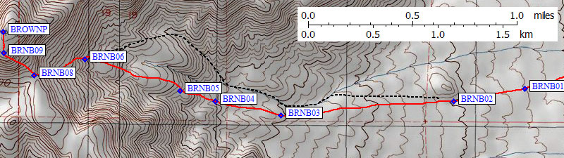
Over 2 miles from the trailhead (waypoint BRNB01) there are some gullies to cross and it finally feels like you're climbing instead of just walking across the desert. Stay south of the 2500' bump (waypoint BRNB02) where the best walking is on the ramp between the washes (NOT in them).
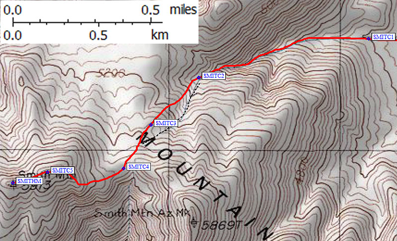
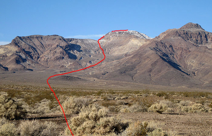
My best guess is that the DPS Guide directs you to the black dashed line on the map below, in a wash which turns into a moderately interesting canyon. This is NOT the best route for distance or good footing! I climbed that route (the black dashed line) trying follow the DPS Guide but I think my descent route (the red line) is far superior. Around 3000' on the black line there are some whiteish (more like yellow) base rock slabs that match the Guide but again I don't think this is an efficient route.
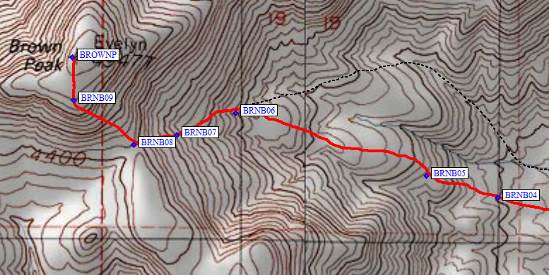
I stayed on the rib south of the biggest wash (waypoint BRNB03) where the footing is good and plants are sparse. Around 3000' (waypoint BRNB04) the terrain is a bit confused as many gullies seem to approach each other without quite merging. Stay up out of all the gullies for the best walking. There is an outcropping and minor saddle at 3300' (waypoint BRNB05) that marks the base of a bowl east of the summit. However you climb into this bowl, head for the base of the slope SE from the peak. Too far south and you'll be clambering through gullies and over out croppings, too far north and you'll be on steep loose rock.
I climbed next to an avalanche gully that looked like a luge run, with basketball size rocks pushed up to form a high berm on all the corners. Crossing this gully just above 3800' (waypoint BRNB06) I traversed up and left to the base of a gravel rib (waypoint BRNB07) leading to the 4400' saddle (waypoint BRNB08) south of the peak. On the way up, climb south of this gravel rib for better footing. On the way down, traverse left (north) below this rib to get on the southern rib between washes for less boulders and no waterfalls.
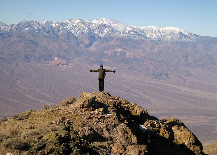
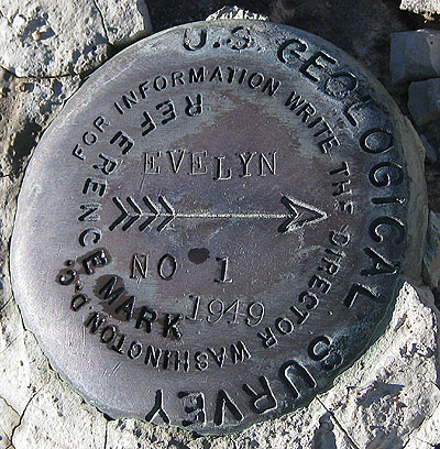
| From the saddle (waypoint BRNB08) to the summit plateau (waypoint BRNB09) I stayed left of the ridgeline on steep but easy terrain. It took 1.5 hr to walk across the desert, another 2 hr to the top (waypoint BROWNP), and the entire return took about 2.5 hours. The snow line was under 5000' and there were minor drifts on top. I never found the register but I did find an Evelyn benchmark. Is that the original name for this peak? (Both names are on map!) |
|
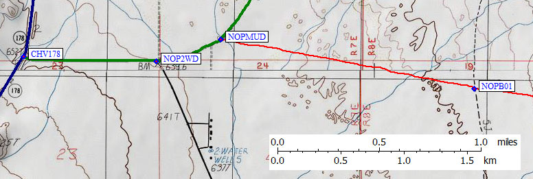
I walked away from the car at 630am, under a completely overcast sky. The local peaks were in the clouds and it had snowed at the trailhead overnight. I followed a gravel road through what could have been a witch's orchard in a horror movie and across mud flats. where the road bends left (waypoint NOPMUD) I went right instead. Not a good place to be after a big rain! It's so flat that you only gain about 20' in the first mile, the soil is find and powdery, and there is plenty of evidence that standing water collects here.
I walked straight across miles of desert with only minimal gain. Around 2500' I dropped into a wash and followed it toward the base of the mountain, but I don't recommend this route (the black dashed line on the map below). The footing is better on the north side of the wash (my red descent line on the map below) than in the wash, plus it's shorter to walk a straight line than to follow the meandering wash.
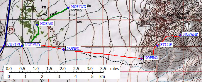
It took less than 2 hours to walk 4.5 miles (as the crow flies) from my car to the base of the climb. That's a lot of flat mud and low angle gravel. The air noticeably cooled as I walked, and some snow flakes drifted down on me as I contemplated whether or not to climb up into the clouds. A brief shower was followed by slight clearing and I decided to get some more exercise even if I couldn't make the summit before the real storm started.
Aim for the prominent/incongruous gray pile of talus that washes out of a bowl (see photo below), and stay right (south) of that gravel pile as you approach the base of the peak. It's unclear where the DPS Guide intends you to get on the ridge, but I went up the yellow line (OK) and came down the red one (much better).
Red line (preferred) matches the red line on my map:
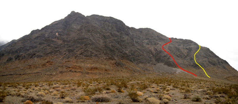
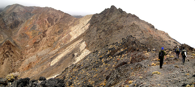
Climb up into the bowl just right (south) of the gray talus fan (waypoint NOPB02), which I think is the best way, or walk as far around the end of the ridgeline as you want. The dark rock of the ridge (above some red layered outcroppings) is sharp but not too loose and the ridgeline is more exciting to climb than the rib marked in red.
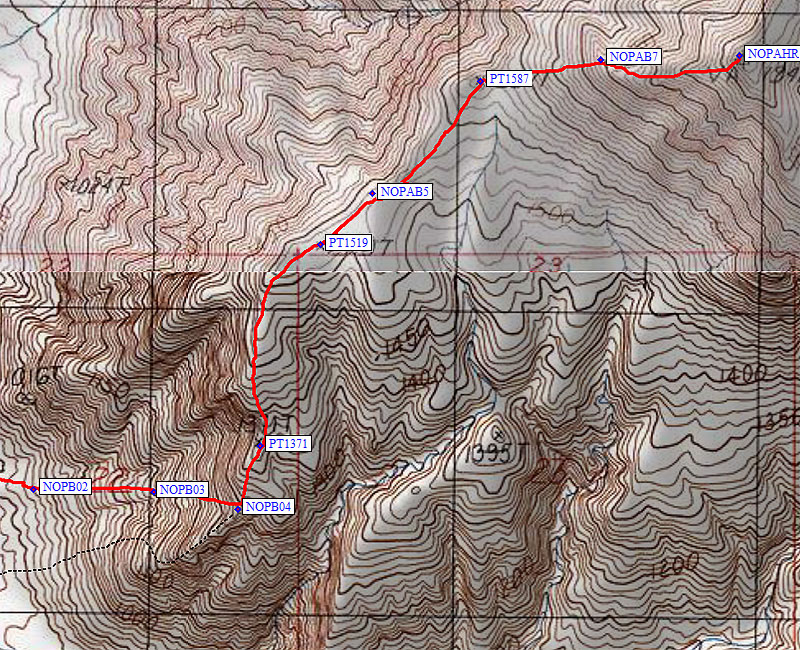
Follow the rib from about 3100-3700 feet, crossing a gully (waypoint NOPB03) and climbing to a 4200' shoulder (waypoint NOPB04) on the main ridgeline. This appears to be much higher than where the DPS Guide has you reach the ridge, but it's where the walking gets easy no matter how you reach it. Turn north and walk up the ridge next to a west-facing cliff. There is no benefit in trying to skirt bumps, just go over places like Point 1371m. The scenery and the footing are both great! On the way down be sure to keep that western cliff face next to you so you don't drift east into the wrong drainage.
The clouds were lifting about as fast as I was climbing. For a while. Around 5000', just after Point 1519m (waypoint PT1519), the howling wind brought lowering clouds and minor mist with temperatures in the 30s. Very nice, indeed! I had layered up back at 4200' where there was still some shelter, but up higher there was nothing to hide behind. The ridge slowly bends from north to east and the route is obvious, so I kept trudging up into the clouds. At Point 1587m (waypoint PT1587) there is a flat shoulder where you turn due east. This is the one area where it's not an obvious ridge climb, and with very limited visibility it was sort of a surprise to hit a cross-ridge (waypoint NOPAB7).
Enough snow to kick steps, if only you can see where you're going:
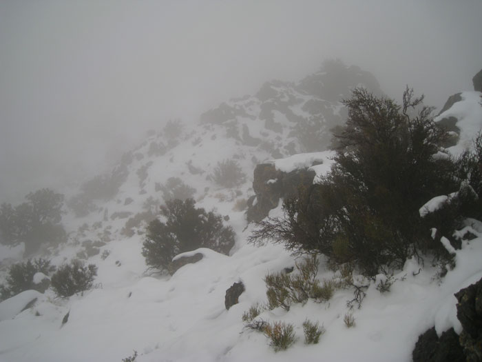
Going down in bad visibility, this is a place to watch out! At 5700' (waypoint NOPAB7) the route drops off the west side of the ridge and I didn't see any obvious way to know where this turn should be made. Make fun of my GPS usage if you want, but alone in the clouds it's better than an altimeter and those are the only two ways to keep track of critical turns. (Unless you're sure you can build a big enough duck.) The barometric pressure was changing during my climb, so altimeter elevations I noted on the way up had "changed" by over 100' on the way down.
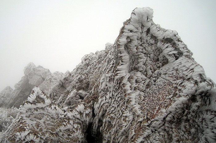
It's not out of focus and it's not turned sideways - that's ice built up on twigs:
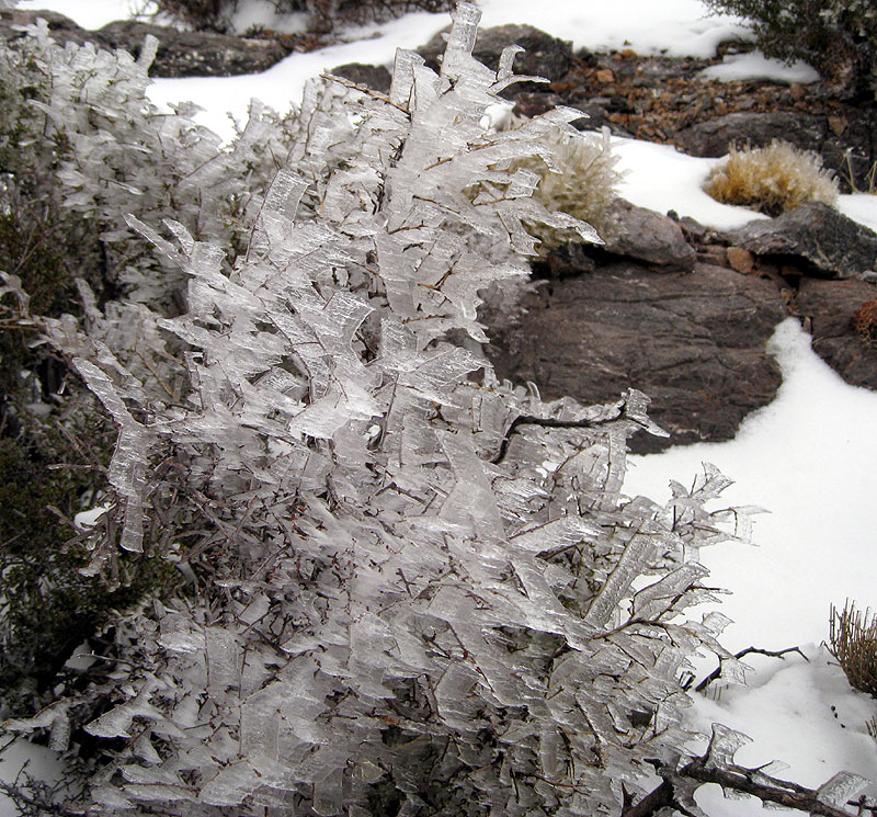
On the summit ridge the bushes were all covered in clear water ice (much clearer than normal rime ice) and soon my clothes and pack acquired a stiff layer also. A bighorn sheep led the way with fresh tracks almost all the way to the summit, although I never saw it. This variation on Route B is 13 miles round trip, with 4300' of gain, and took me about 5 hours up and 3.5 hours back. A reasonable dayhike with no 4WD or high clearance vehicle required. Oddly enough, I killed a mosquito back at the car. In December, after snow flurries at that elevation. The bugs might be nasty here in warmer/wetter times!
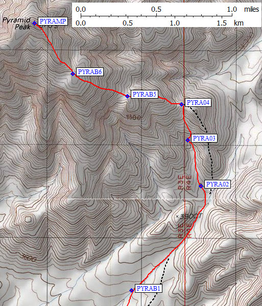
| On the way up, we followed the DPS Guide's Route A to the right (east) of Point 3900 and ascending the ridge that splits the drainage at 3800'. This ridge had some loose rock and some sidehilling, then featured a drop far larger than the one contour line shown on the USGS maps before climbing back up to the 4600' shoulder (waypoint PYRA04) and slightly down to a saddle. This saddle is where the black rock of the lower ridge meets white rock, a MUCH better place to reach the ridge! The red line on my map is our descent route, the black dashed line is where we climbed. Everyone preferred our descent route, so I'll describe that as a climb. |
|