Wupaki Ruins at dawn:
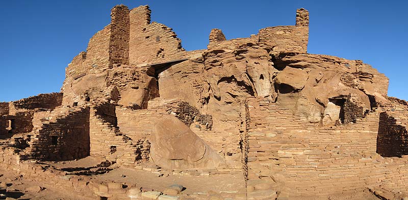
These, and others like Box Canyon, are Pueblo ruins worth seeing while you're here!
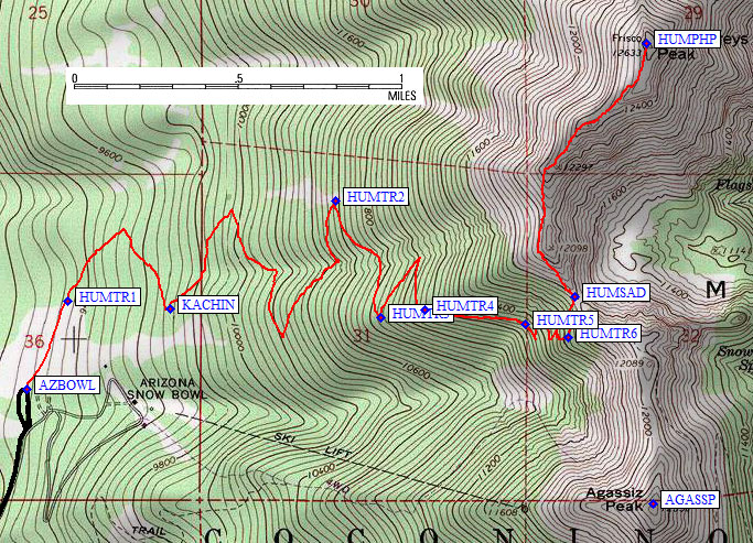
I left the huge trailhead parking lot around dawn. The trail is well built and easy to follow. It does NOT go quite where the DPS Guide says it does. See the map below for a GPS track log. Most (if not all) available maps were made before the trail was... including the big one on the trailhead sign (which is definitely wrong about the details of where the trail really IS).
You leave the parking lot going north across a meadow, and enter the trees at waypoint HUMTR1. I'm guessing no one will need this waypoint unless there is serious snow on the ground, and I'm guessing that since the trailhead is right next to a ski resort you can climb it pretty much all year. There's a sign-in box at the edge of the Kachina Peaks Wilderness (waypoint KACHIN), and a few switchbacks later the trail reaches the edge of the woods at a large boulder field.
The trail avoids the valley where the ski lifts are, and as it climbs it ends up on the north side of the ridge defining that valley. At waypoint HUMTR3 it touches the ridge, and some people have gone straight up here. There is one final switchback, and at HUMTR4 the trail crosses the ridge and sidehills due east toward the saddle.
At waypoint HUMTR5 there is a sign saying off-trail hiking is not allowed above this point (which it SAYS is 11.4k, but the sign is 100' below that elevation). No camping beyond this point, etc. This is the base of the final sketchy switchbacks leading you to the saddle (waypoint HUMSAD) at 11.8k. Note that the final segment of trail before the saddle is going due north, not east.
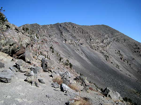
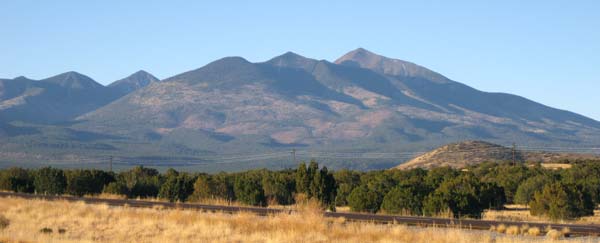
Views of this stupendous peak from the saddle, and from the far northeast (near Wupaki Ruins):
It took about 3.5 hours to reach the summit, and it was very cold the whole way. Not such a problem until I hit the full force wind on the ridge. I was bundled up, but net a runner in shorts and a thin shirt, no pack or supplies. To each his own. He told me (while shivering) that he was counting on keeping moving to keep himself warm.
It was hazy. It was cold. I had a headache. I went home without doing Agassiz as I had planned. But I left my GPS on for the hike down to capture the track log below and document the REAL trail location. Neither the DPS Guide nor the trailhead sign's topo map have it quite right. The trailhead page has more details on camping and driving!
Track Log and waypoints from the trailhead to the summit:
![]() Download the Waypoint+ data below as a GPX file for your GPS.
Download the Waypoint+ data below as a GPX file for your GPS.
Datum,North America 1983,GRS 80,0,-1.6E-7,0,0,0
RouteName,1 ,Humphreys Peak
RoutePoint,D,SPCAMP, 35.2576500177,-111.6651799679,11/03/2008,01:49:51,SHULTZ PASS RD CAMPSITE 7500
RoutePoint,D,SPRMEL, 35.2397300005,-111.6612700224,02/12/2009,22:16:22,SCHULTZ PS RD JCT MT EDEN LOOKOUT RD
RoutePoint,D,SPJ180, 35.2385783195,-111.6689443588,02/12/2009,22:15:29,SHULTZ PS RD JCT HWY 180
RoutePoint,D,ABJ180, 35.2683399916,-111.7189500332,10/08/2008,23:50:33,ARIZONA BOWL RD JCT HWY 180
RoutePoint,D,AZBWL1, 35.2842772007,-111.7189526558,10/08/2008,23:50:55,
RoutePoint,D,AZBWL2, 35.2834951878,-111.7058992386,10/08/2008,23:51:05,
RoutePoint,D,AZBWL3, 35.2938079834,-111.7051839828,10/08/2008,23:51:14,
RoutePoint,D,AZBWL4, 35.3021168709,-111.7210984230,10/08/2008,23:51:27,
RoutePoint,D,AZBOWL, 35.3310750723,-111.7115578651,10/08/2008,23:39:15,ARIZONA SNOW BOWL
RoutePoint,D,HUMTR1, 35.3349800110,-111.7093100548,11/03/2008,01:49:51,ENTER FOREST
RoutePoint,D,KACHIN, 35.3346300125,-111.7037899494,11/03/2008,01:49:51,KACHINA WILDERNESS BNDY
RoutePoint,D,HUMTR2, 35.3394500017,-111.6948299408,11/03/2008,01:49:51,TRAIL TOUCHES LARGE BOULDER FIELD
RoutePoint,D,HUMTR3, 35.3342700005,-111.6923700571,11/03/2008,01:49:51,TRAIL DETERIORATES
RoutePoint,D,HUMTR4, 35.3345999718,-111.6899800301,11/03/2008,01:49:51,CROSS RIDGELINE
RoutePoint,D,HUMTR5, 35.3339799643,-111.6845500469,11/03/2008,01:49:51,NO OFF TRAIL ABOVE HERE
RoutePoint,D,HUMTR6, 35.3333899975,-111.6822099686,11/03/2008,01:49:52,NO MORE SWITCHBACKS
RoutePoint,D,HUMSAD, 35.3351900578,-111.6818499565,10/08/2008,23:46:54,SADDLE 11800
RoutePoint,D,HUMPHP, 35.3464000225,-111.6779600382,01/26/2008,10:29:40,8_2 HUMPHREYS PK 12633