Hawaii: Climbing Mauna Kea
|
Mauna Kea |
Monday - Friday, June 19-23, 2006
Another year's highpointing
epic is under our belts. Given the need to identify a college that suits Nathan, and his
having been invited to sing in a choral event in Honolulu, we combined
a trip through California to visit several colleges, the choir tour and
the southernmost state highpoint into one trip.
We flew to LAX, drove up to the Bay Area and flew out to Hawaii from SFO.
We chose to stay in Hilo rather than the much-more-touristy Kona area.
Hilo gives better access to Mauna Kea, but if you want kitsch, stay in
Kona. We rented a 4WD Explorer from Harper's Car Rental in Hilo.
As many Highpointers Club members already know, Harper's is the only
agency on the island that allows their vehicles to be driven to the summit
area of Mauna Kea.
Saturday, June 24, 2006
We got up early and ate breakfast at Ken's House of Pancakes, conveniently
only a few blocks from our hotel. Great breakfast...good service and very
much a local place...definitely not just for tourists. We drove up the
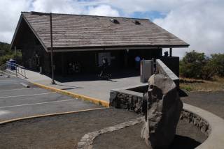
newly-improved route 2000 to the observatory visitors center at about 9,200'
on the slopes of Mauna Kea. They recommend you stay there for at least a
half-hour to acclimate and see if you are going to have immediate problems
with the altitude. After our stop, neither of us was suffering particularly,
having loaded up on Tylenol before we left sea level.
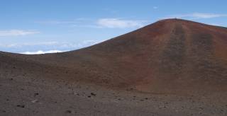
As you approach the summit of the road, there is a large gravel parking area
on the left a hundred yards or so before the high point of the road. A faint
use trail is visible that countours across to the more-commonly-used trail from
the road down a small saddle and back up to the summit, proper.
Ever unwilling to hike "down" to hike "up," we chose to hop over the guardrail
and use the fainter but more nearly level trail. It joins the other trail near
the low point of the saddle. All-in-all, it's maybe a quarter-mile and a couple
of hundred feet of gain to the summit. The main trail follows the ridgeline in
the view to the right.
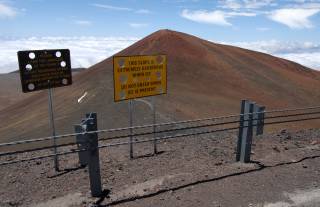
If you do drive up to the top of the road, you are greeted by signs
warning of danger if the slope is icy and cautioning you not to disturb
the rocks in this almost-extraterrestrial landscape.
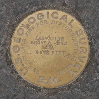
The trail up the summit ridge is visible behind the signs and leads up
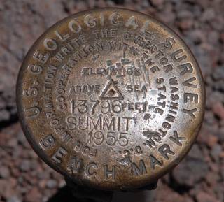
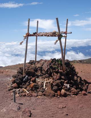
to the summit with its Hawaiian altar and USGS benchmark.
During the winter, it is not uncommon for the upper parts of Mauna Kea
to receive significant snowfall. With the winter of 2005/2006 having
been one of the wettest on record, it was not too surprising to find
the remnants of the winter's snowfall still present on this otherwise
tropical island. Temperatures on the summit were in the upper 40s, with a bit
of a breeze, so the fleece jackets we had brought to Hawaii definitely
came in handy. Overnight temperatures near the summit fall to near
freezing even in mid-summer, according to the forecasts on the
Mauna
Kea observatory website. You can also see a live webcam view of the
summit on the NOAA
Mauna Loa weather observatory website (which used to be at www.mlo.noaa.gov/LiveCam/FcamMK.htm).
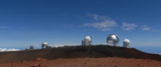
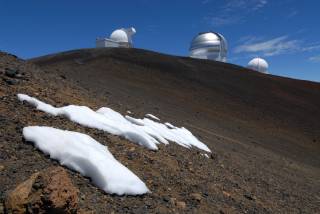
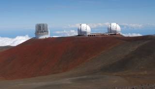
The summit area is populated by a variety of astronomical observatories
owned and operated by various countries' universities. Probably the
best-known of these are the twin domes of the Keck multiple-mirror
telescope. Unfortunately, we were there on a Saturday, so the
visitors center for the Keck telescope wasn't open and we had to
content ourselves with a walkaround of the exterior of the building.
As you can see in the background of this shot, a low deck of clouds had
begun bo build, and we drove through clouds and mist as we descended
back through the 9,200' level and passed the Onizuka visitors center
on our way down the mountain.
Sunday, June 25, 2006
Having accomplished our first goal for the trip, we returned the
Explorer to Harper's and rented a more-efficient Ford Focus for our
further touring of Hawaii. On Sunday, we drove a lap of the Big
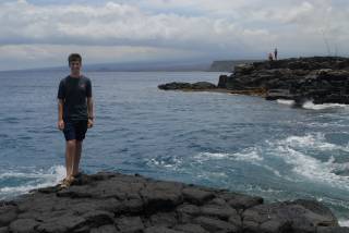
Island and checked off another geographic extremum, the southernmost
point in the U.S. along the south coastline of Hawaii.
Monday, June 26, 2006
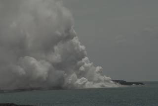
Our last day on the Big Island, we drove through Hawaii Volcanoes National
Park. Both Mauna Loa and Kilauea volcanoes are active at the moment, and
the drive down the Chain of Craters Road takes you to the point where a
lava flow overran the road a few years ago. From there, a short walk
across the cooled lava crust brings you to this overlook where you can
see the steam cloud generated as the current lava flow meets the Pacific
Ocean. (It is also possible to hike considerably closer to the flow, but
we were limited on time before we had to return the rental car, so
settled for the more-distant view.)
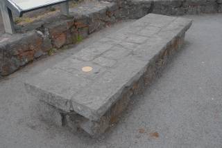
As highpointers, we're very familar with USGS benchmarks on summits and other
points of geographic significance. At the Kilauea visitors center,
however, there is one that really is a "bench" mark...it is set
into a stone bench on the rim of the Kilauea crater. I suppose
that someone at the USGS actually has a sense of humor!
The road that circles the Kilauea crater passes by a number of interesting
sights, including a large lava tube and several subsidiary craters and
vents that have been active at various times. The road itself obviously
leads a rather tenuous existence as you drive along stretches that have
been built over fairly recent flows from the 70s and 80s.
Tuesday, June 27 - Monday, July 3, 2006
With my 41st and Nathan's 39th highpoint under our respective boots,
we boarded an inter-island flight back to Honolulu for Nathan's choir
tour the following week. The kids, many of whom hadn't been off the
mainland before, had a great time and performed very well.
Now, Nathan and I just need one more Western Region highpoint and we
can get our 40-state highpointer pins. Probably not this year, maybe
next year...
Respectfully submitted by
Alan Ritter, July 2006

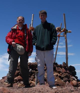
On top of the highpoint of Hawaii and the tallest mountain on earth (counting,
of course, its base at the bottom of the Pacific), we took the requisite
summit photo, recorded a GPS waypoint of 19 49.242' N, 155 28.086' W
and shot a summit panorama.
(See mtritter.org/Mauna_Kea/Pans/ - You will need a Java-enabled browser to view the panorama. The
file is quite large, so if you're not on a high-speed link, it may take a while
to load, as well.)
The Eclectic Traveler
To file a trip report, please fill in the Report Entry form or contact the webmaster.