We started from the Red Mtn 4WD trailhead (not a sno-park, but overnight parking seems to be OK). This trail was mostly packed by snowmobiles, but poorly marked once you got a few miles from the highway. It starts near Tamarack Creek, but climbs around the north side of Boneyard Meadow before heading to Red Lake and finally to Coyote Lake. We trudged up the tracks until they ended, then a bit further up the road until an unmarked junction that's not on the map, then we spent more time with map and compass (and perhaps the occasional GPS reading).
The terrain is mostly low slope, in the trees, with few visual references for navigation. It would be a great ski trip except my ankle still bothers me from a ski accident last year. We were quite pleased to hit Coyote Lake within a few feet of our target (the outlet stream), where we had running water at 9k in early April. Most lakes we went by had some access to running water, and the streams were open below 8k. A moderate pace got us to Coyote (9 miles and about 2100' gain) in just over 8 hours. It seemed warm in the fading sun, but got down to 15 deg overnight.
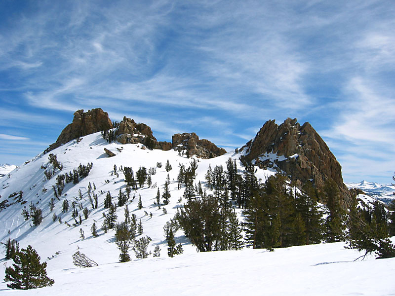
| We left camp Saturday morning just as the sun hit us, making a beeline to First Dinkey Lake. The trail goes up over a 9600' shoulder before the lake but the best winter route is to stay near 9300' and head for the lake outlet. Continuing to Second Dinkey Lake and over Point 10179, we finally got a decent view of our objective, Dogtooth Peak (click on the picture for a larger image): |
|
We headed for the highest saddle, which has a stand of trees in it, stopping at a lower saddle to put on crampons:
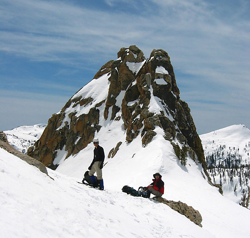
| Well, OK, I didn't put on crampons. I was testing my brand spankin new MSR Lightning Ascent snowshoes, and they were awesome! A 6" surface layer sometimes broke loose, but I had no trouble gripping the surface or kicking through it to sink the snowshoes into the lower layer of snow. This part was pretty steep (perhaps 30 degrees), and required self-belay with an ice axe handle due to the unstable surface layer. |
The west side of the peak is a serious-looking face. We kicked around route options with Gordon's report in mind (a few exposed 3rd class moves), but didn't like anything we saw. We walked through the highest saddle, to the SE side of the summit block (facing Courtright Reservoir). Warm dry rocks were inviting, but all we did was drop some gear and keep scrambing.
| The SE side of the summit block is pretty basic 3rd class, no sense of being exposed, and it's only 20' until you reach 2nd class again. This might be different in the summer, but there didn't seem to be much snow on that exposure. Even with stiff plastic boots and some ice on the rocks it was pretty easy.
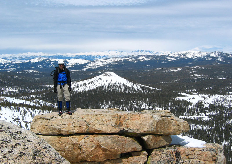
Once on top, we took required photos of all the local bumps, watched a major storm building over the eastern Sierra, and decided not to visit any of them on this fine day. (That's Black Peak behind Rob, and when planning the trip I was delerious enough to think we'd want to make a 3 mile detour to bag it.) |
|
An hour later it was completely cloudy. Four hours later we had a fine dusting of snow. Those "sun dogs" and the lenticular clouds were telling us to get out while the getting was good.
The next morning we starting walking around dawn, hoping to bag Red Mtn on the way out. We agreed that if the sky was blue when we walked under it we'd drop our main packs and run up it. The sky was blue. We dropped our packs. The sky clouded over. We aborted before we started. Then the sky turned blue again. Sigh. Anyway, we had lost the momentum and the clouds were whipping over the summit from time to time, so we headed out.
Instead of walking down the road, we went cross-country to the south of Boneyard Meadow on the way out. When we hit a road at a bridge over Tamarack Creek it took a bit to realize that this was the summer hiking trail, used by snowmobiles in the winter. We followed it for a bit, then popped back to our side of Tamarack Creek on a great snow bridge. The storm was waiting for us! A gentle snow fell steadily as we changed clothes and packed the car, and the heavy rain started less than 5 miles from my house after a dry drive home.