|
| This would be my seventh attempt at my namesake mountain, climbed first in 1872 by John Muir. Two of the previous attempts had been ended by bad or threatening weather, and the other four by a combination of bad route information and a certain level of conservatism about climbing lousy metamorphic rock. It would be Yehuda's third trip up with me, and would have been Pat's second, save for a broken car just before the trip last year, which prevented him from getting there. |
| Lambert airport was a real zoo. Checked bags at the curb, since the check-in line stretched all the way out of the terminal. I stood around as long as I dared, but my bags were still on the curb 50 minutes before flight time. Hope they made it onto the plane! We'll find out in a couple of hours. Despite the long lines upstairs, check-in at the gate was uneventful, and I made it onto the plane with time to spare. The flight pushed back right on time (8:50 a.m.), so TWA met their on-time goal on this one, at least. It was a smooth flight, with clear skies. |
| The plane made good time, arriving in Reno nearly 20 minutes ahead of schedule. Baggage took less than 10 minutes to arrive, and my bags were among the first off (hmmm...does that mean they were last on???). I picked up my rental car at Alamo (too bad...they were out of the compact I had reserved, so had to give me a mid-size at the same price). I drove over to the Sierra Trading Post store and did some shopping, as is my habit on these trips. Found a couple of bargains, plus one thing I had seen in their catalog...a battery-powered LED flasher nominally meant for bicycles, but just the thing to clip to your tent as a beacon to home in on if you are coming back to camp after dark. |
| The drive down to Mammoth took the usual 3 hours, with a couple of soda and stretch stops. Looking to the west as I passed the Shell station at the south end of the June Lake Loop, I greeted Banner Peak and his taller brother, Mt. Ritter, our goal for this trip, through a gap in the intervening hills. |
| I stopped at the Mammoth ranger station and checked their trail condition notebook (nothing more recent than two weeks old, which is typical, so I left them a copy of Dana Chaney's report which he had emailed to me just the day before.) I checked into the motel and hauled everything into the room. |
|
By that time, it was approaching 5 p.m., so I headed up
to Minaret Summit to do an initial intelligence run for
the upper part of the climb. It certainly looked a LOT
different from last year. Between six feet less snow and
being here three weeks later in the season, the upper bowl
was probably 2/3 devoid of snow, so we would have a talus slog
from at least 12,000' on up. That may work in our favor...we
shall see.
I also drove down to Agnew Meadows, where the mosquitoes swarmed around me in 30 seconds. We would have to apply bug gunk BEFORE we got there on Monday morning. |
Note: I am now thoroughly convinced that Dana and Vince climbed a VERY steep and exposed chute which is clearly visible even from Minaret Summit. Owen's Chute, on the other hand, is hidden from view unless you know to make a U-turn immediately after you pass the "three-toed" buttress. From a distance, their chute looks every bit as scary as Dana's description, and certainly leads to the ridge considerably south of the upper bowl. |
| Time for dinner, then time to start organizing and packing gear. |
Sunday, July 25: Acclimation and Reconnaissance
| I took my time getting going Sunday morning, sleeping in late until about 7 or so. After checking the weather forecast (still nice through the five-day period), I walked across the street to Blondie's for pancakes. I drove back up to Minaret Summit as a base of operations for checking out our proposed climb route. Walking south first, I located the clearing from which Owen and I had viewed the middle and upper parts of the route last year. The upper bowl is clear of snow from the ridge at least halfway down to the exits from the chutes up from the glacier. Owen's Chute looks to be partly snow, partly dry, but he maintains that it climbs easily either way. Certainly, the top part of the climb will be a talus slog, but at least we shouldn't have last year's problem of punching through thin spots in the snow. |
|
|
After a few photos, I meandered the 3/4 mile (per my GPS) back to Minaret Summit. From there, I headed north along the Jeep trail which ends up at Deadman Pass. I stopped perhaps halfway to that point, about a mile-and-a-half north of Minaret Summit, since that area was high enough to see the lower part of the climb, but not so far north that Mt. Ritter blocked any of the view I needed. |
|
The gully we plan to climb up from Ediza is
still mostly snow-filled, and the landmarks for our turn point
look the same as last year. We'll go above a rock with a
prominent single tree, and turn right above the next ridge of
rock. From there, the snow bowl looks very much like last
year, and from there we will be on the Southeast Glacier,
proper.
I drove back to Mammoth and called Owen Maloy and Rich Calliger. Rich was still iffy about whether he would make it the next morning, so his joining the group will be a spur-of-the-moment event. I had lunch with Owen Maloy, then returned to the hotel to finish packing. Yehuda and Jason called about 6:30, and we met up for dinner at the Mountain Cafe, along with Owen. We discussed plans for the climb, and Owen assured us that it was "a walk-up". We agreed to meet at Agnew Meadows the next morning at 7:00 a.m., to beat the 7:30 closing of the Minaret Summit Road. |
|
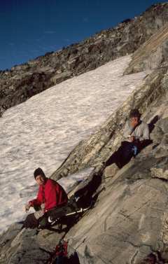
| I got up at 5:30, finished loading the car, and met Jason for breakfast at Blondie's. He walked back to the Motel Six, and I walked across Main Street to the Econolodge. We all made it over to Agnew Meadows in plenty of time, and I drove to the second trail-head parking lot in search of Pat Ibbetson, who had planned to drive over the night before and just sleep in his truck. Sure enough, Pat was there and still sawing logs. It turns out that he had not arrived until 2 a.m. (something about leaving his boots in Sacramento and driving half the night to fetch them) He said he would catch a few more winks and meet up with us at Ediza Lake. | |
| I filled up my fuel bottle from Yehuda's gallon can, made a last check for anything missing, and we were off toward Ediza Lake at 8:00 a.m. We made good time, pausing at the bridge across the San Joaquin River and again at Shadow Lake, there to take our first look at Mt. Ritter. |
|
| Jason was suitably impressed, and we continued along the trail. We arrived at Ediza Lake about noon, and made our way around the north side of Ediza, scrambling over a hundred yards of boulders rather than walking around the south side, which is a half-mile longer, involves a couple of stream crossings and meandering through a large swampy meadow that is a perfect breeding ground for the clouds of mosquitoes which infest the area immediately around Ediza. Jason stopped to sink a food cache in a hidden spot near the shore, since he will be doing a through hike of the John Muir Trail in August. Hopefully, his waterproof packaging really will be waterproof and his cache will remain hidden from both four-and two-footed raiders. | |
| We made our way along the use trail up the first gully past the boulder field and encountered our first snowdrift in a sheltered pocket on the north side of a large granite outcrop at about 9,300'. Shortly, we found a suitable campsite, complete with Yehuda-approved bear-hang tree, at about 9560', per my Casio altimeter watch. Jason and Yehuda headed back down to Ediza for an afternoon swim in the chilly 57-degree water, while I wandered up to get a closer look at our proposed route for the next day's climb. |
| As I strolled across the braided-stream area between Ediza and the base of the Ritter/Banner glacier, I heard someone call my name. It was Pat, who had apparently rounded Ediza and either missed us or, more likely, simply headed up the wrong drainage, since there are several gullies up from Ediza, each with use trails. I finished my reconnaissance and joined Pat to show him where we had camped. |
 |
 |
The recon was valuable, since the gully we planned to follow as the initial part of our climb was mostly filled with snow, but terminated a series of rocky waterfalls which would have been a pain to climb. There was, however, a series of grassy ledges and rocks to the left on which would be easy to hop up high enough in order to reach the snow above its wet terminus. |
| When everyone was in camp, we discussed the plans and route for the climb. Yehuda's idea was to treat this as an Alpine ascent, by getting up at 3:30 a.m. and starting the walk over to the base of the climb using flashlights at 4:00 a.m. This schedule caused great wailing and gnashing of teeth from Pat, who was already sleep-deprived from his late-night arrival. Ultimately, he acquiesced, warning us that he is not a morning person, but would get up and moving with us. | |
| After dinner, we packed our day packs for the summit attempt, put the next day's food into BRFCs, hung the rest of the food out of reach of bears, and settled down for what would be an all-too-brief night. | |
| 3:30 a.m. rolled around all too quickly, especially considering that I had slept only fitfully, thinking about the climb. A quick cold breakfast, and we were on our way about 4:15 a.m., following the use trail up to a point level with the start of our climb, then turning left across the valley to the grass slopes leading up to the lower gully. By first light at 5:00 a.m., we were poised to start climbing for real. |
 |
 |
We made good progress up the lower gully on snow firmed by overnight temperatures in the 40s. We passed the scrub trees where Yehuda and I had made our time-consuming mistake last year, and continued up to the top of the gully to make our right turn toward the snow bowl and Southeast Glacier. With six feet less snow, and three weeks' more summer melt, the scene was markedly different from 1998. The route from the top of the gully to the snow bowl was over pleasant solid 2nd-class rock. |
| The snow bowl was still mostly snow-filled, and there was the usual trail over the drifted ridge and onto the glacier. The ridge this year had been wind-sculpted into a more severe peak, pushing us onto 3rd-class snow conditions, as expected. We were on the glacier by 8:00 and took a short break on the large rock outcrop near the bottom of the glacier. Pat moaned over the amount of the climb that would be on snow, as he is not as comfortable on snow as on rock, and slows down a bit out of caution. |
 |
|

|
|

|
By 9:00, we had reached the third toe of the three-toed buttress and made our U-turn into Owen's Chute. It was totally devoid of snow, and presented a jumbled slope of talus and scree. Yehuda and I headed up the left side of the chute, as this was the easier area when snow-filled, as it was last year. Jason paralleled us perhaps 50 feet to the right and, as it turns out, picked a better line, as Yehuda and I ended up with 20 or 30 feet of 3rd-class climbing to reach the top of the chute. With Jason already waiting for us and giving pointers, we wasted fewer than 5 minutes on the 3rd-class pitch, and reached the upper bowl by 10:00. |
| From there, we could see a relatively flat snowfield which we crossed without crampons and the talus slope leading up to the summit ridge. A second, steeper, snowfield stretched part-way along the upper slope, and we skirted the left edge of this snow, since it was faster and easier to stay on the rock. There are actually the traces of a use trail visible in the gravelly areas amidst the talus, so route-finding is easy at that point. We passed the false summit which looks so tempting from below, going to the right of this rather steep outcrop. I was lagging just a bit behind Jason and Yehuda when they reached the summit ridge. A minute or two later, I spotted them sitting on the ridge, motioning me on and saying that the summit was mine to lead. There are two bumps on the west end of the ridge, the second one being a few feet higher, and it was a simple, but exciting scramble those last 100 or so feet along the ridge to the summit log in its cast-aluminum box. |
|
|
10:45 a.m., July 27, 1999, was the culmination of a 14-year, seven-attempt odyssey. Yehuda snapped a first photo of me standing triumphant on "my" mountain. Then he and Jason scrambled over to join me and sign in the log. Pat caught up with us perhaps five minutes later after a few pointed remarks about the last scramble and the exposure to the north side of the ridge, which is extreme, to say the least. |

|
| We savored the view from the summit, took pictures with Pat's, Yehuda's, and my cameras, and spent an hour or so on the summit, heading back down about noon. We retraced our route down noting Jason's easier, all-2nd-class path through Owen's Chute, back down the Southeast glacier on softening afternoon snow. Jason tried valiantly to boot or butt glissade, but most of the glacier is either too low in angle or too sun-cupped (or both!) to allow long glissades. The rest of us settled for down-climbing or short slides into sun cups, and Jason was waiting at the bottom of the glacier for us. |
 VR Movie of 360-degree panoramic view from the summit. Note: This is a 700k file, so be prepared for a bit of a wait! |
|
The hop back over the snow ridge and into the snow bowl was a bit tenuous on the sloppy snow, and each of us slipped enough once or twice to remind us how to self-arrest. Pat was the only one to take a more serious slide, which he arrested safely, but not quickly enough to avoid giving himself a good fright in the process. Once again, over the rocky ridge and into our gully, which seemed a bit steeper by virtue of its softer surface. Here, Jason could build up a fair head of steam on his glissades and beat us down the 500' of the gully by a large margin. As we scrambled down the grassy slopes, I spotted the interesting rock formation in the photo to the left. It appeared that an ancient climber had fallen and remained face-down in the brush, turned into granite by some chance of fate. A casual walk across the streams to the use trail, and we were safely back in camp by 5:30 p.m. |
| It had taken us 6-1/2 hours to reach the summit, and about 5-1/2 to return. Over 7,000' of total "up" plus "down", and we were tired but happy mountaineers. We managed to find enough energy to fix dinner (well, Jason had so much excess energy that he went down to Ediza for a swim before dinner...ah, youth!!). I pulled two airline bottles of Scotch out of a pocket of my pack, and we drank a celebratory toast to our success. Cutty Sark never tasted so good!! | |
Wednesday, 28 July: Back to Civilization
| We awoke about 6 a.m., which felt like "sleeping in" after the previous day! Pat was the first one packed, and left right away, having to get back to Fresno in time to do some "real" work later that day. Jason, Yehuda, and I fixed breakfast, packed up and left Ediza Lake about 8:45. |

|
|
| We paused for photos at the outlet to Ediza and again at Shadow Lake. My repaired Achilles tendon was bothering me a bit, so I fell perhaps 15 or 20 minutes behind Jason and Yehuda on that last miserable 400' climb back up from the river to Agnew Meadows. I reached the parking lot about 12:30, poured my leftover fuel back into Yehuda's gallon can, and packed up the car. Jason and Yehuda headed back for the Bay Area, and I drove down to Devil's Postpile, where I knew there was a handy pay phone. | |
| A first call to TWA to change my return flight to Thursday instead of Sunday, then a call home to let Marcia and Nathan know that I was off the mountain safely and, yes, I had made it to the top!! One more call, to let John Fraser, my climbing buddy of many years, know that I had done it, and then time to head back to civilization. | |
| On the way out of Mammoth, I stopped at the ranger station to fill out a trip and trail report. While there, I ran into a father and son who were planning to climb Mt. Ritter from the west side in a couple of days. We swapped stories, and I cautioned them that their plan to camp at Thousand Island Lake and to climb Mt. Ritter as a day hike from there might be just a little bit aggressive, having been back there and knowing what a slog it is from North Glacier Pass down to Lake Catherine, and that it is a fairly tough cross-country route from there to the base of the climb from the southernmost of the Ritter Lakes. I left them a business card with my email address and hope to hear back from them when they return. | |
|
A chicken sandwich from McDonald's and I was on my way.
Just south of Lee Vining, I stopped at my favorite spot for
a last view of Ritter and Banner, no longer mocking me, but
now old friends peering through the afternoon haze.
The three-hour drive to the airport motel in Reno went pleasantly enough. Finally, a shower, a real dinner, and I was almost back to human. Packed things up for the flight, hit the sack at 11:45 with my alarm set for 4:45 to catch the 6:30 a.m. TWA flight back home. |

|
| I should have been suspicious when I walked out of the motel in Reno and there was a black cat curled up on the doormat! The Best Western driver got me to the airport in fine time (well, it's all of a five-minute drive), but when the gate agent checked my ticket and re-booking information on his computer, TWA showed me as booked on the 6:30 a.m. flight for Friday, not Thursday! Of course, the flight is over-booked now, so I am on priority standby. One can only hope for a few no-shows. |
| Success!! Enough no-shows that I made it onto the flight. Because of people running late at the ticket counter, the flight was a few minutes late taking off, but not bad. We arrived in St. Louis on time at 12:05, so the flight was within the slack allowance at takeoff time, anyway. Perhaps the black cat's purpose in life was, instead, connected to the unaccompanied 8-year-old sitting next to me, who got a bit airsick halfway through the flight (but that's another story...) |
| Thanks first to John Fraser, who started me on this quixotic quest some 14 years ago, and to my wife, Marcia, for putting up with the whole epic struggle. |
| Second, thanks to Yehuda Ben-David, Pat Ibbetson, and Jason Novak for joining the final, successful, team. (Rich Calliger, you, too, could have been there!) |
| Thanks also to a long and varied list of participants in the various iterations of the pilgrimage: My son, Nathan; John, Lindy, Andy, and David Fraser; Lori McConnell, Jesse Kingsley, and Martin Jabs; Tom and Ed Milner; and Yehuda's wife, Nancy Wolfe. |
| Finally, thanks to all of of the PCS folks, especially Owen Maloy for his route information, and everyone else for information, counsel, and encouragement over the years. |
| Now I can get on to some other peaks...state highpoints like Mt. Whitney and Boundary Peak, and other interesting peaks like Shasta. |
Climbing Route Description for Mt. Ritter
| Disclaimer: Mountaineering poses significant risks. The route description which follows is not meant to train anyone in climbing techniques. If you fall off the mountain and break your fool neck or any other part of your anatomy, do not send your lawyers, heirs, etc., after me, the Peak Climbing Section, climber.org, or whomever. You decided the rewards were worth the risks and you accepted those risks when you left the trailhead! |
|
The following route description and illustrations represent the
evolution of a route which has been developed over three trips up
to Mt. Ritter. For a different look at this route,
please check out my
1998 route description, which describes the same basic route,
but under vastly different snow conditions.
The winter of 1997/1998 saw well over 500" of snow at nearby Mammoth Mountain, and we made our 1998 attempt in early July, camping on snow above a frozen Ediza Lake. You can read about that attempt and the overall conditions in my 1998 trip report. By comparison, the winter of 1998/1999 dropped just over 400" of snow on Mammoth, and we were up on Mt. Ritter three weeks later in the summer. As a result, we spent about half the climb on rock instead of snow. The big differences were two-fold: First, we knew the route better and made no time-consuming route-finding errors in 1999. Second, as is evident from the body of this report, we got a very early start on the climb, which helped both in avoiding the brutal mid-to-late-morning sun on the Southeast Glacier, as well as giving us more than enough margin before our stated turnaround time of 2 p.m. Those two significant differences gave us the summit. As far as the route's difficulty, I would rate it (conservatively) as 95% second-class snow and rock. There are a couple of spots of steep (>45deg) snow, especially that wind ridge as you get onto the Southeast Glacier, and Owen's Chute can be done either on solid second-class talus and scree, or up a couple of hops of low third-class breaks. I would also caution that the final summit ridge is very exposed to the north and should be treated with all due respect even though it is a pleasant scramble. Note: Images in this description which show as links point to large copies of the same image. Please be aware that they are often greater than 1k x 800 pixels and will take a while to load. However, the visual detail provided may come in handy if you try to follow this route. Ok, enough background! Let's get to the route itself! |
|
|
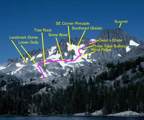
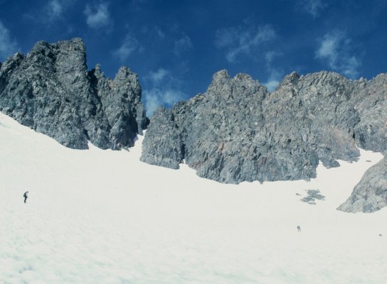
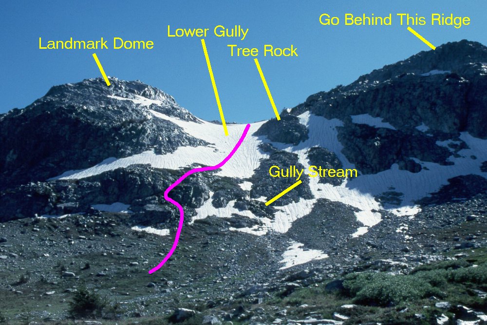
The view from Shadow Lake provides a good vantage point for looking
at the lower and middle parts of the climb. Important landmarks are
the dome to the left (south) of the desired lower gully, the "tree
rock" about 1/2 to 2/3 the way up the gully, the pinnacle at the
corner of the Southeast Glacier, and the "three-toed buttress" which
marks Owen's Chute.
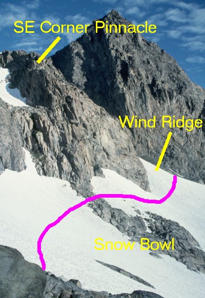
The next photo will show the very bottom of the climb, but once you are in the lower gully, go almost to the top before turning right over the ridge. If you turn at the "tree rock", you end up in some nasty 3rd and 4th class cliffs, as Yehuda and I did in 1998. Going all the way to the top (or nearly so) leaves you an easy 2nd-class scramble over the rocky outcrops to the snow bowl. You then contour around the snow bowl, staying low enough not to risk a fall into the gap between the snow and rock, and to find a relatively-less-steep point to cross the wind ridge which diagonals down from the pinnacle. You then turn up the Southeast Glacier and continue up past all three "toes" of the three-toed buttress before making a sharp right turn (almost a U-turn) into Owen's Chute, which is hidden behind the buttress in this view. We'll pick up the top part of the climb after a couple more detail photos along the way. |

|
|
Standing in the glacial valley above Ediza Lake, where the exit
stream braids its way among the granite outcrops, you will get
this foreshortened view of the lower gully. The features are
identified as on the previous view, and it is obvious from this
view that you can get confused about where the "top" of the
gully is, due to the varying slope of the snow, which is steeper
in the lower stretches and flattens out a bit after a ridge about
halfway up.
The landmark to avoid is the "tree rock". Keep going well above this and go above/behind the ridge at the upper right in this photo. The stream which exits the gully lobbies for starting the climb either to the left (as we did) or to the right of the gully. You could also go a bit farther to the left and dodge some of that lower outcrop, but it's just a scramble, nothing more, so is easily and quickly overcome. |
|
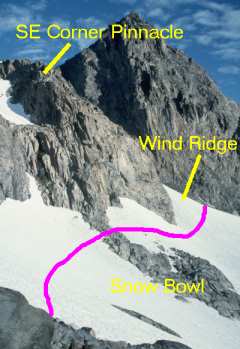
Once you walk over the rocks, you will see this snow bowl. This
year, there was a tongue of rock sticking down from the pinnacle
at the corner of the glacier, but it was narrow enough at the
top to walk across without removing crampons.
The process here is simple...contour around the bowl, staying well below the snow/rock line, and then climb over the wind ridge at the far side of the bowl. The wind ridge is the only place the snow is really steep, clearly more than 45deg, so a bit more caution is advisable for that short pitch. Once over it, you are onto the Southeast Glacier, proper, and the climbing is again easy on moderate-angle suncupped snow. |
|
|
|
|
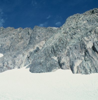
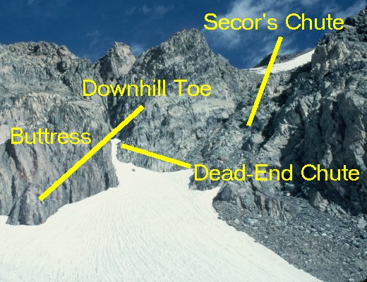
As you leave the large rock outcrop at the snout of the Southeast
Glacier, you see its expanse spread out in front of you. Immediately
above you and to the right are Secor's chute and a steep, narrow,
dead-end chute full of really slick slate. (I know whereof I speak
from my 1994 attempt which ended in that chute.)
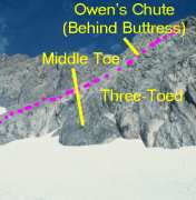
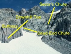
Secor's chute is blocky but doable, although the snow headwall above it can be intimidating, depending on how the winter storms blew in and how steep the slope is on the snow. Owen's Chute, just beyond the uphill "toe" of the "three-toed" buttress, is the easiest route to the upper bowl. If you stay to the right of the rock outcrop in the middle of Owen's Chute, it is moderate class 2 talus and scree. To the left, there are a couple of spots of not-particularly-difficult third-class rock, so it works either way. |

|
|
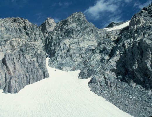
When you reach this point, you are really in the home stretch.
You have about 500 vertical feet to climb, and on the rock, it
is an easy stretch, save for the fact that you have to watch
for the wandering oxygen molecules and snag the few that meander
by!
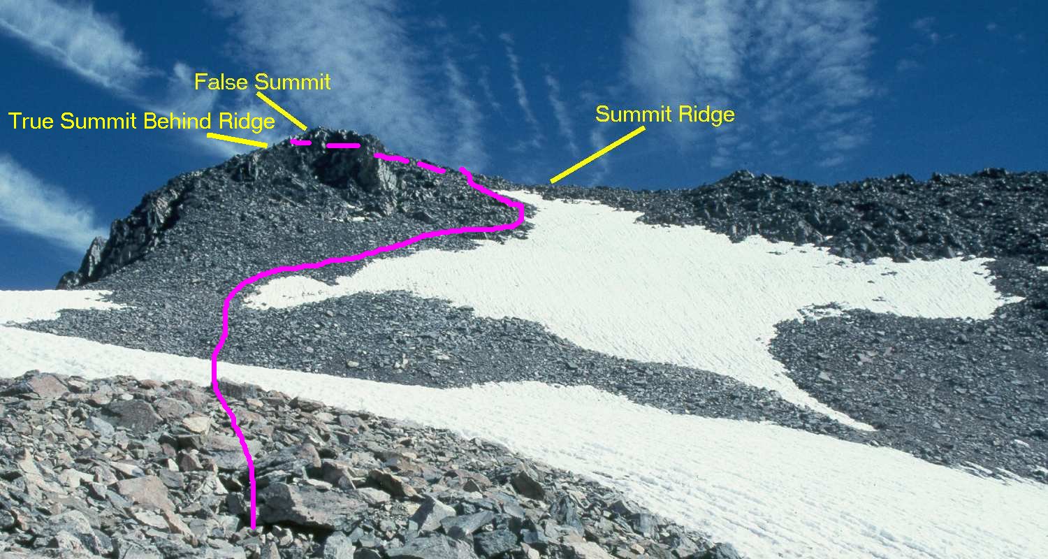
From the top of Owen's Chute, the route is quite straightforward. You cross the lower snow field, which is at a shallow enough angle not to require crampons, then skirt the left edge of the upper, steeper snow field until you reach the summit ridge. A couple of hundred feet of basically horizontal scrambling along the ridge take you to the summit, proper. Do mind the exposure to the north, though. It would be a quick but painful trip down if you went over it to that side. What appears to be the summit is actually a bump on the upper slope which sticks out far enough to be tantalizing, but is a bit lower than the ridge and true summit, which are obscured behind it in this view. From this point, it took us about 45 minutes to reach the summit on an absolutely gorgeous day. |
|
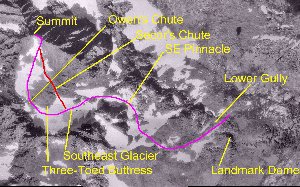
This annotated image, made up of USGS orthophotoquads, shows an aerial
view of the whole climb. Obviously, the USGS photos were taken in
a somewhat drier year than either 1998 or 1999, since there is quite
a bit more exposed rock than there has been lately.
The image links to a medium-sized (600-pixel) copy of the image. There is an even larger, 1500 x 900 pixel, image available if you have the patience to download it. |
Pre-climb Reconaissance of Mt. Ritter
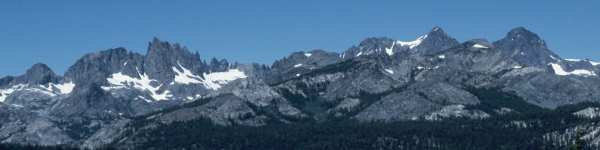
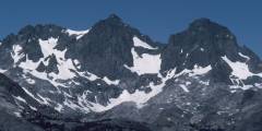
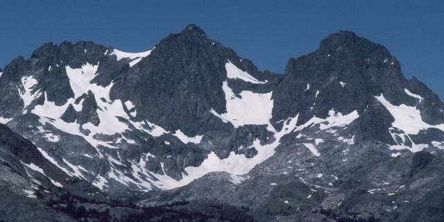
A Panorama of the Ritter Range
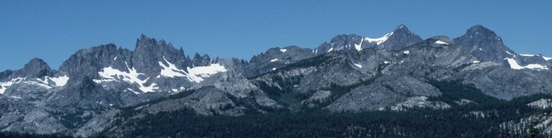
| This panorama shows the entire Ritter Range, from Banner Peak and Mt. Ritter on the right to the Minarets on the left. Volcanic Ridge forms the feature sticking up between Ritter and Banner toward the right, but is, in fact, several thousand feet shorter and a couple of miles closer to my vantage point on the western slopes of Mammoth Mountain. |

|
This closeup is taken from a spot about 3/4 mile south of Minaret
Summit, just a bit farther south than the panorama, so the crest
of Volcanic Ridge would appear to the north of Banner Peak. In this
enlargement, the upper part of the Southeast Glacier, the
"three-toed" buttress, and the whole of the upper bowl are
visible in the left-hand quarter of the photo. The steep
chute going nearly straight up to the ridge just to the left
of the upper bowl is the one Dana and Vince climbed. Although
doable, it is very steep and exposed, making it a much less
desirable choice for a route between the SE Glacier and the
upper bowl.
"Owen's Chute" is invisible, hidden behind the left ridge of the buttress which comes down from the middle/left part of the upper bowl. The main snow field at the bottom of the upper bowl is not particularly steep, but the upper fragment of snow is, but can easily be avoided by skirting its left (west) edge. |
|
This second photo is taken from a spot about 1-1/2 miles north
of Minaret Summit, along the Jeep trail which follows the ridge
up to Deadman Pass. It shows the middle parts of the route
much more clearly, since Volcanic Ridge is no longer blocking
the view.
It is useful in this phase to point out the "three-toed" buttress which forms the main landmark for navigating on the SE Glacier. Here, it looks like a foot with three toes pointing diagonally down into the SE Glacier from the upper bowl, just to the left of and above the point where the steep ridge line intersects the SE Glacier. |
John Muir's Commentary on his First Ascent of Mt. Ritter
back
Mt. Ritter (13,150') is named after Carl (also spelled "Karl") Ritter, a 19th century German geographer under whom Josiah Whitney studied in Berlin. Whitney, in turn, was responsible for mapping much of the American West, and is the person after whom Mt. Whitney (14,494'), the highest point in the lower 48 states, is named. The Ritter Range, consisting (from north to south) of Banner Peak, Mt. Ritter, and the Minarets, is a part of the Ansel Adams Wilderness, located in central California, just south of Yosemite National Park.
Mt. Ritter was first climbed by John Muir in October, 1872. His route approached Mt. Ritter from the west, coming out of Yosemite and ascending the western glacier which lies between Mt. Ritter and Banner Peak on the opposite side of the saddle visible from the east.
Muir's first ascent was not without a degree of risk, as he writes:
"At length, I found myself at the foot of a sheer drop in the bed of the avalanche channel, which seemed to bar all further progress. The tried dangers beneath seemed even greater than that of the cliff in front; therefore, after scanning its face again and again, I commenced to scale it, picking my holds with intense caution. After gaining a point about half-way to the top, I was brought to a dead stop, with arms outspread, clinging close to the face of the rock, unable to move hand or foot either up or down. My doom appeared fixed. I must fall. There would be a moment of bewilderment, and then a lifeless tumble down the once general precipice to the glacier below. When this final danger flashed in upon me, I became nerve-shaken for the first time since setting foot on the mountain, and my mind seemed to fill with a stifling smoke. But the terrible eclipse lasted only a moment, when life burst forth again with preternatural clearness. I seemed suddenly to become possessed of a new sense. The other self -- the ghost of by-gone experiences, instinct, or Guardian Angel -- call it what you will -- came forward and assumed control. Then my trembling muscles became firm again, every rift and flaw was seen as through a microscope, and my limbs moved with a positiveness and precision with which I seemed to have nothing at all to do. Had I been borne aloft upon wings, my deliverance could not have been more complete. Above this memorable spot, the face of the mountain is still more savagely hacked and torn. But the strange influx of strength I had received seemed inexhaustible. I found a way without effort and soon stood upon the topmost crag in the blessed light."
Having been to that point on Muir's route, I can appreciate his quandary, for it was there, or nearabouts, that we decided discretion was the better part of valour and backed down from our second attempt.
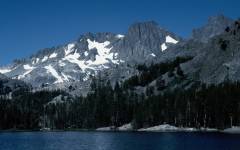
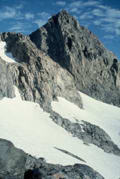
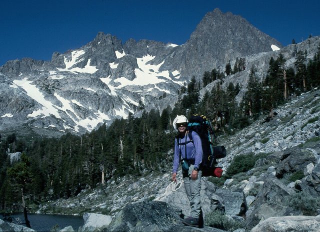
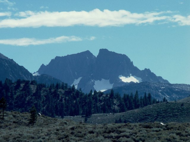
Mt. Ritter and Banner Peak from the Shores of Shadow Lake
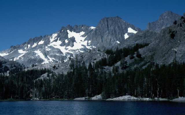
|
You are rewarded for making the steep 700-foot climb from the San
Joaquin river up to Shadow Lake with one of the most spectacular
and arguably the most picturesque views of Mt. Ritter. This is
my "standard" shot of Mt. Ritter, and I now have a whole collection
of these, shot during the various attempts at "my" mountain from
the east side.
From this point, you can see most of the lower 2/3 of our route up the mountain, starting in the snow-filled gully to the left, crossing over the snow bowl in the left-center, and up the Southeast Glacier right in the center of the photo. |
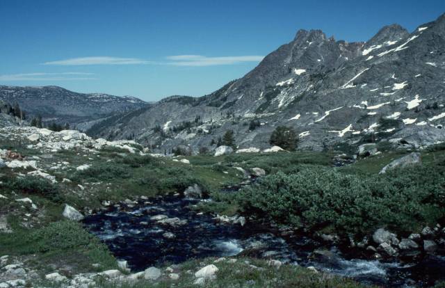
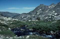
| The outlet stream from the Ritter/Banner glacier starts at about 10,000', flows through a glacially-carved valley and down into Ediza Lake. As it meanders through notches in the outcrops, it divides into several branches, each of which follows its own path down to the lake. The area above timberline is partially grass, partially brush, and criss-crossed by the braided streams and use trails. |
|
The lower gully, well to the south of Mt. Ritter, is easily spotted
by looking for that granite dome to the left of the gully, at the left
side of this photo. When using the gully as an approach, the trick is
not to exit the gully at the first tempting spot, which is marked
by a tree on the rock on the right-hand side of the gully in this photo.
Doing so dumps you into a series of rather nasty 3rd and 4th class steps
and low cliffs. Going 100 yards higher and behind the taller ridge to
the right of the gully leaves you with an easy scramble over flat to
gently-sloping rock to the snow bowl adjacent to the SE glacier.
In this average snow year, there is a small stream flowing out of the snow in the gully, forming a series of splashing waterfalls as it courses down the rocks. This wet and slick route is easily avoided by going a bit further to the left and walking up the grassy slopes and over the low rocky ridge, picking up the snow in the gully above where the stream begins. |
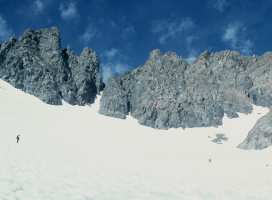
Get up Early and Watch the Sunrise
Definitely a View for the Early Birds!

| As we approached the snow in the lower gully, the sky in the east over Nevada began to turn a rosy pink. We would no longer need our flashlights, although sunrise was still some time away. |
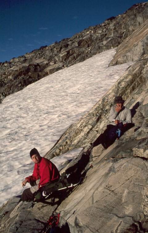
| At the top of the lower gully, Pat and Jason stop to stow their crampons, bask in the warm glow of the rising sun and load up on the sunscreen. |
|
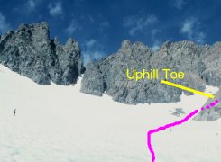
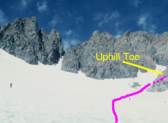
Crossing this snow bowl is a simple matter of contouring around it.
We aimed for the upper, narrow, part of the tongue of rock sticking
down from the pinnacle at the corner of the SE Glacier. The stretch
of rock was short enough to hop over in a few steps without removing
our crampons, saving precious minutes. We then went
around the pinnacle and over that ridge of snow which drifts
diagonally down to the right edge of the photo. This year, the face
of the ridge was quite steep, about 50 degrees, so a modicum of
caution is warranted. Still, there is plenty of snow runout on
which to arrest if you do slip out. Just be prepared!
Not visible, but to the left of this photo, another band of snow goes up and through a notch on the uphill side of the pinnacle. Jason wondered whether it might be better to go up instead of straight across. I cautioned him that the drifting patterns inside the bowl of the SE Glacier might cause some problems, and it turns out my assessment was exactly correct. As we topped the ridge of snow, we could see down on the south margin of the SE Glacier and noted that there was a near-vertical face of snow some 20 to 30 feet tall between the upper band of snow and the glacier itself. Going that way would not have worked well this year! |
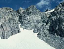
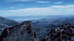
Multiple-Choice Test: Which Chute is Which?
Looking North/West from the Southeast Glacier
|
|
|
|
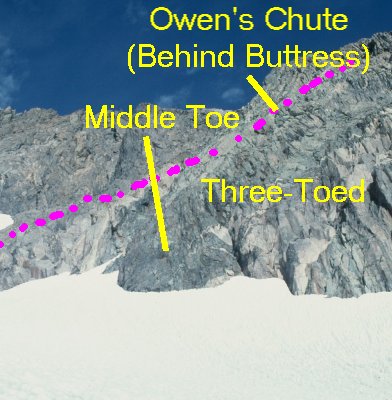
Note: These three images stretch out quite wide. Please pan your
browser to view the full set. Looking at the "three-toed" buttress
from the Southeast Glacier, the two standard chutes are easy to pick
out in the right panel of these three photos. All the way to the
right is Secor's chute, wide, relatively shallow, and very
blocky climbing. Just to the left of Secor's chute is a narrow,
steep, and climber-unfriendly chute. Been there, done that, never
want to see that Teflon-slick slate again!
Owen's chute is at the right-hand edge of the left panel, where the third "toe" of the buttress projects out into the SE Glacier. It is not visible from this angle, since you climb to the end of the "toe" and basically make a U-turn to get to it. It is, however, at the shallowest angle of the three and presents an eminently-doable second-class route from the glacier to the upper bowl. |
| Here is a bit better view of Secor's chute, from a little farther up the SE Glacier. The chute heads up dead-center in this shot, and the blockiness of the terrain is quite obvious. In addition, depending on the amount of snowfall and direction of drifting, that headwall of snow visible at the top of the chute can be threateningly steep. Given the exposure to all of those blocks near the top of the rocky stretch, climbing even a short stretch of 50-degree snow might be somewhat intimidating if you head up that route. Still, it is another alternative. |
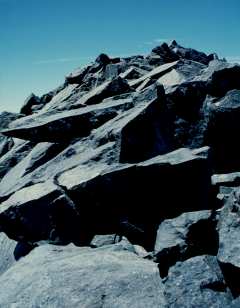
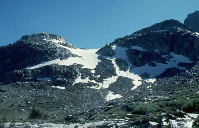
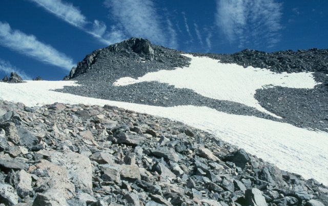
Mt. Ritter's Upper Bowl and Summit Ridge
back
|
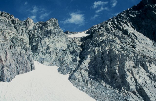
This view of the upper bowl and summit ridge clearly shows our
route to the summit. We crossed over the near snow field, then
followed the left edge of the upper, steeper, snow field until
we reached the ridge. From there, it is a simple scramble over
the block talus to the summit, proper.
The apparent summit in this view is false. It is an outcrop just below the summit ridge which projects far enough out to block the view of the actual summit, which lies behind and perhaps 10 or 20 feet above the outcrop. |

| Once you reach the summit ridge, you are presented with this rugged aggregation of fractured desk-sized blocks. Although not perfectly clear in this view, there are two humps along the ridge, the second (western) of which is the true summit. Looking to the left, or south, you see the 45-degree talus slope up which we just scrambled. Looking the other way gives you a view of the much steeper north side of the ridge which drops a few hundred feet to the Ritter/Banner saddle to the northeast and 2000' to Lake Catherine to the northwest. |
Success at Long Last...the Summit of Mt. Ritter

back
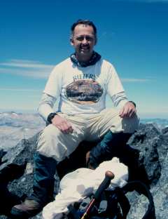
| The fact that it took seven attempts over a period of fourteen years made the final success all the sweeter. Properly attired in a Ritter Biergarten T-shirt, I sat for a formal portrait atop my eponymous mountain. Thanks to R.J. Secor for reminding me of the word "eponymous"! |
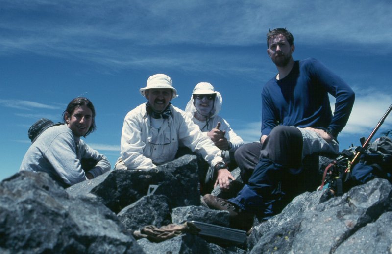
| Here, the whole group poses atop the summit. From left to right, Jason Novak, your faithful scribe, Yehuda Ben-David, and Pat Ibbetson. The aluminum box containing the summit log is visible in the center foreground. |
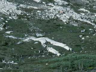
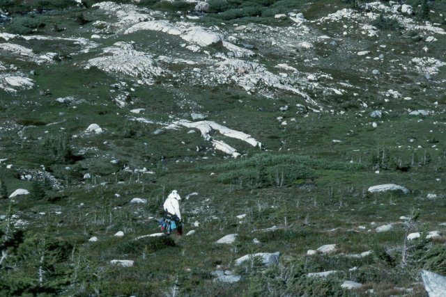
The Petrified Mountaineer below Mt. Ritter
Yehuda Approaches the "Petrified Climber"
back
|
Obviously, prehistoric mountaineers were considerably taller than
we modern folks, as is evident from the relative size of Yehuda
versus the "petrified climber" ahead of him.
Ok, I admit it...maybe I have been on one too many tours of places like "The Garden of the Gods", but it is amusing to anthropomorphize certain features. |
Posing by Ediza Lake, with Mt. Ritter as a Backdrop
Yehuda and Jason at the Outlet from Ediza Lake
back
| Yehuda and Jason posed for a final shot with Mt. Ritter in the background. The north shore of Ediza Lake, visible in the lower left corner of the photo, is a rather rugged boulder field, but the effort spent scrambling over a few hundred feed of boulders saves at least a half-mile walk around the south shore. |

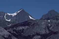
A Last Fond Look at Mt. Ritter and Banner Peak from Hwy 395
Mt. Ritter and Banner Peak Basking in the Late-Afternoon Sun
back
|
As you head north on highway 395 from Mammoth to Lee Vining, you
come to a long downhill stretch leading to the flats before highway
120 up into Yosemite. If you look to the west as you start down
that hill, you can catch this last glimpse of Banner Peak to the
right and Mt. Ritter behind and to the left. From this angle, you
would not suspect that Ritter is 200 feet taller than Banner, but
it is a trick of perspective.
At the left, just before the intervening ridge cuts off the view, you can see the pinnacle at the south edge of the Southeast Glacier, and the snow ridge over which we had climbed the day before. |
Enlarged View of the Lower Parts of the Climb

The Lower Gully from the Valley above Ediza
|
|
|