Friday, 11 June
|
We left after work and drove to Bloomington, IL for the night.
We dodged the worst of the thunderstorms, but did drive through
some rain along the way.
|
Saturday, 12 June
|
We headed on north to Rockford, IL, then out west to Galena.
After eating lunch in Galena, we meandered up to Charles Mound,
the Illinois highpoint. Note that if you ask directions in Galena,
you'll have much better luck if you ask about the old stagecoach
road to Scales Mound, rather than asking directly about Charles
Mound. The road at the north end of the village of Scales Mound is
aptly named Charles Mound Ave., and takes you directly to the
driveway leading up to the Wuebbels farm which contains the summit
of Charles Mound. The GPS logged the location as 42deg 30.213'
North, 90deg 14.381' West. We paused long enough to sign the
summit log, shoot photos of each other, and of the USGS benchmarks
marking the highpoint.
|
|
Our destination for the night was Wausau, WI, conveniently close
to our next highpoint.
|
Sunday, 13 June
|
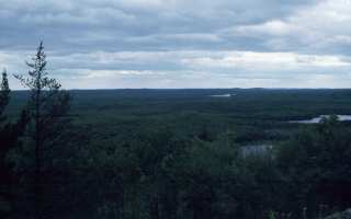
We drove north from Wausau to Tomahawk, and then west toward
Timm's Hill, the WI highpoint at 45deg 27.045' North,
90deg 11.757' West. Once there, a pleasant wooded
walk of less than 1/4 mile brings you to the summit, marked
with a benchmark and occupied by a radio/fire tower and an
impressive wooden observation tower. From the top, the view
is expansive, and I shot a 360-degree set of slides from which
to derive a panoramic image.
Note: This is a 600k file and will take a while to load!
|

|

|
We continued north to Duluth, MN, for the night. In Duluth,
the Army Corps of Engineers has a free maritime museum which
chronicles the history of shipping on the Great Lakes. It is
certainly a worthwhile way to spend a couple of hours before dinner.

|
|
|
We left Duluth, headed for Grand Marais (pronounced Grand Ma-rays
by the locals) and Eagle Mountain, the highpoint of Minnesota.
Construction delays held us up, and it was lunchtime when we
arrived in Grand Marais. We ate lunch at a spot called "My
Sister's Place", and dropped Marcia at the motel so Nathan and I
could do the highpoint.
|
|
Eagle Mountain lies within the Boundary Waters Canoe Area
wilderness, so a day-use permit is required, These are available
free of charge at the ranger station in Grand Marais. While
there, be sure to ask for a copy of the trail map, the reverse
side of which has a map of the otherwise ill-documented county
roads which lead to the trailhead.
Once at the trailhead, the trail is easy enough to follow, with
only one well-marked fork at the base of Eagle Mountain, proper.
Virtually all the elevation gain comes in the last mile or so,
and much of that is in the first few hundred yards up from the
last lake you pass along the way.
|
|
We made good time, taking about an hour-and-a-half for the
stated 3.5-mile trail to the summit at 47deg 53.849' North,
90deg 33.599' West. As mentioned by Roger Rowlett, the view
from the summit, proper, is obscured, but there are several
more expansive vistas visible from the trail just prior to
the summit, from one of which I shot this
panorama. Again, the VR
panorama files are big...over 600k...so it takes a while
to download.
|
|
|
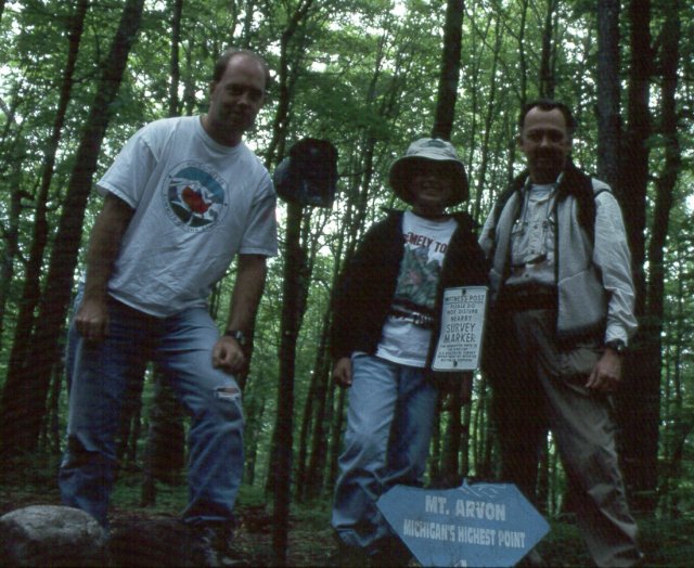
We left Grand Marais and cut across the top of Wisconsin to the
Upper Peninsula of Michigan. We arrived in Baraga in time for
dinner, having stopped at the Michigan line to pick up our usual
official highway map, and to inquire about detailed and current
information about the route to the trailhead for Mt. Arvon, the
Michigan highpoint. We had various horror stories about a maze
of logging roads and the difficulty of finding the proper trail,
so were pleased to find that the Highpointers Club had provided
a reprint from one of their magazines, along with a photocopied
update which added further details.
|
|
It was raining lightly when we woke up, but had stopped by the
time we finished breakfast. We sat around for just a bit before
hearing from Dan Johnson, another highpointer we had met on our
hike up to the
Arkansas
highpoint in December, 1998. Dan lives in Minneapolis and had
decided to drive over and meet us, having tried twice without
success to find Mount Arvon.
|
|
Dan ran into the same construction delays that we had crossing
northern Wisconsin, so it was after 11 a.m. by the time we headed
from Baraga (Pronounce that "Bear-aga") back to L'Anse and
on over to Mount Arvon. Between Dan's memory of his previous
attempts, GPS waypoints and the more-detailed directions we had
picked up at the tourist information center at the Michigan
border, we managed to find the right set of old logging roads.
|
|
We really only took one wrong turn along the way. At one point,
you drive through a gravel pit. As you enter the pit, you see
two possible exit roads, both heading roughly in the correct
direction. We arbitrarily chose the road to the left, only to
realize a half-mile later that it was veering too far to the east,
forcing us to back-track and take the other choice. About 50
yards into the woods down the right-hand exit road, there was one
of the blue-diamond "Mt. Arvon" signs which was not visible from
the depths of the pit.
|
|
According to the directions, we should have parked the car and
walked a mile or so. However, we continued along
gradually-deteriorating roads until I was worried that the Saab
would run out of ground clearance and/or traction.
|
|
|
At that
point, my GPS indicated we were just over 0.2 miles from the
summit, so we had only a short walk along the final muddy
track to the path which leads the last hundred yards to the
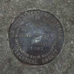
summit marker at 45deg 45.330' North, 88deg 9.325' West,
benchmark, and log book.
A few photos, and it was time to carefully turn the Saab around
and make our way back to civilization. After lunch, we bade
Dan safe travels back home to Minnesota, and spent the remainder
of the afternoon wandering up to Copper Harbor.
|
Thursday and Friday,
17 and 18 June
|
|
Travel days...from the U.P. down to Clare, MI, on Thursday,
then on to Findlay, OH, (with a short detour to visit a fellow
Fiero fanatic near Saginaw, MI, along the way) as a convenient
staging point for Campbell Hill, MI, on Saturday.
|
|
We left Findlay and continued south on I-75 to Lima, where we
picked up Ohio 117 southeast toward Bellefontaine. Somewhere
along the line, I missed a turn and we meandered quite
a way along various county roads before rejoining OH 117. It
then merges with US 33, a few miles before Bellefontaine. As we
approached town, we found OH 540, and turned east for a short
distance to the Hi-Point Vocational School.
The campus is not usually open on weekends, but there was
some sort of picnic going on, so the gates were open.
(The school will attempt to accommodate weekend highpointers
if you call ahead to 937 599-3010 and make arrangements for
access.) We drove up to the parking lot next to the
maintenance buildings and soon found the highpoint
benchmark at 40deg 22.242' North, 83 43.202' West and
flagpole between two of the buildings.
|

|
|
From there, we returned to I-75, drove south to I-70 and
turned west toward Indiana. A couple of miles into Indiana, we
turned north onto Indiana 227 at Richmond. We continued north
to Bethel. About 1/4 mile north of Bethel, we turned west (right)
onto the county line road. From there, it is perhaps 1/2 mile
to Elliott Road, which leads south. We passed a farmhouse on
the right, and started looking for the stile over the fence
surrounding the copse of trees on the right. Drawing a blank,
we continued south another 1/4 mile to the next farm, where we
found the farmer working in his barn. Obviously, he has learned
that odd people with out-of-state plates have passed up the
highpoint, so he merely points back to the trees and says that
the path is in the south margin of the grove, which is why we
missed it as we drove past the east side of the grove.
|
|
|
Note: The correct way to find the highpoint is to
turn right into the margin of the cornfield just to the south
of the grove of trees, park, and walk between 50 and 100 feet
away from the road along the south edge of the grove. You
will see a pile of rocks, and a few feet further from the road,
a short path to the stile (provided by the Highpointers
Club) over the fence, and the sign and cairn which mark
the highpoint itself at 40deg 0.060' North, 84deg 50.932'
West.
|
|
There is a logbook in a wooden box bolted to a tree nearby,
to your left as you cross over the stile. We signed in the
logbook, took a few summit photos, and concluded our
highpointing for this trip.
Retracing our path back down to I-70, we continued west to
Indianapolis for the night.
|

|
|
The trip from Indianapolis home to St. Louis was uneventful.
We tallied over 2900 miles on the Saab and checked off
another half-dozen state highpoints along the way.
|
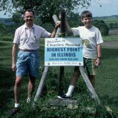
Charles Mound, (1,235'), The Illinois High Point
back
|
Charles Mound, a few miles from the village of Scales Mound,
lies near the Illinois/Wisconsin border in the far northwestern
corner of Illinois.
|

|
|
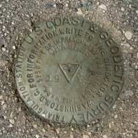
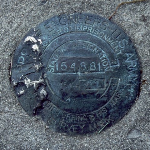
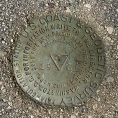
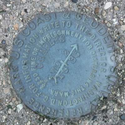
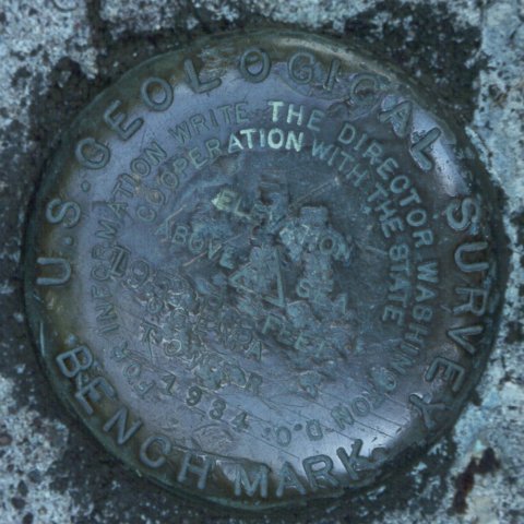
For some reason, there are two USGS benchmarks at
the Illinois highpoint, one dated 1935 and a newer one dated
1985.
|
|
|
|
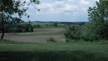
The view from the highpoint overlooks gently-rolling fields.
It is easy to see why this is Charles Mound, not
Charles Mountain!
|

|
back
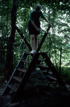
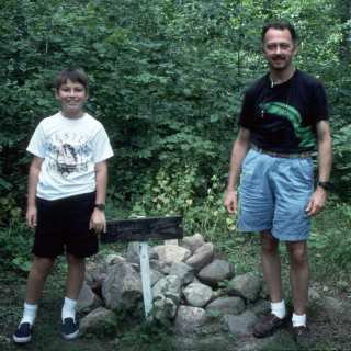
Hoosier Hill (1,257'), The Indiana High Point
back
|
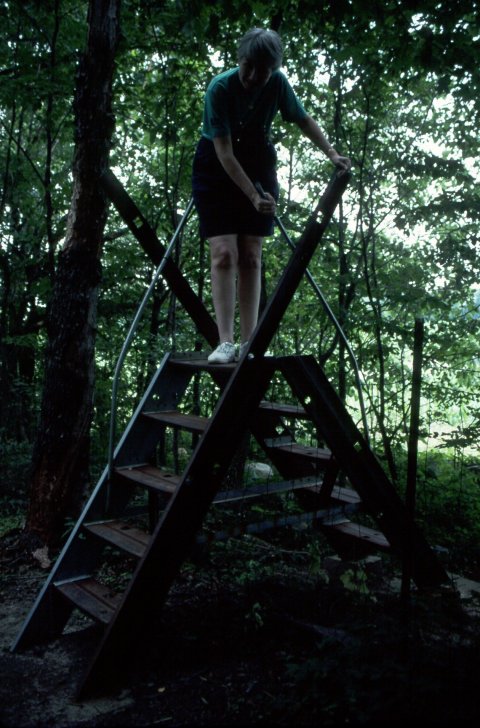
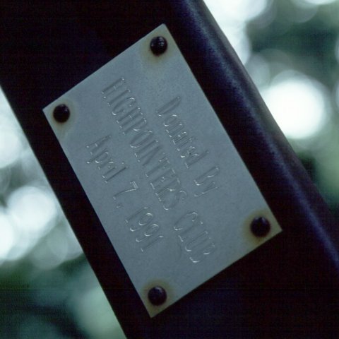
Nearly at the limit of her tolerance for vertical exposure, Marcia
managed to make it over the steel stile in style. The marker on
one of the supports notes that it was provided by the Highpointers
Club and installed in 1991.
|
|
|
|
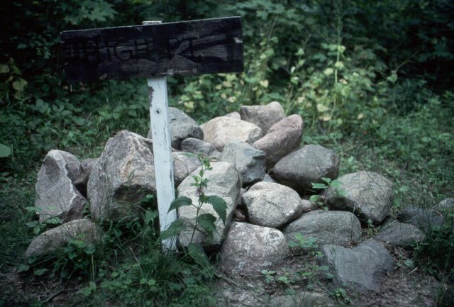
No USGS benchmark here in Indiana, but this impressive hand-lettered
sign and cairn mark the exact high point. The sign reads (not
surprisingly) "HIGH PT."
|
back
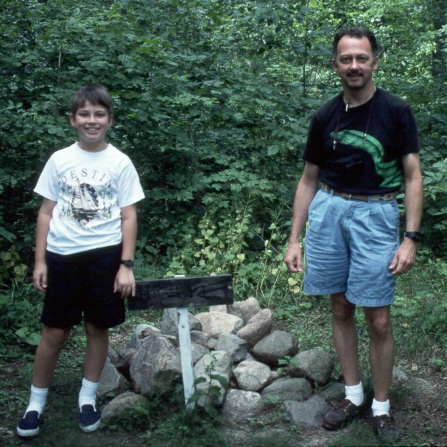
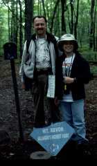
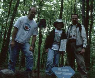
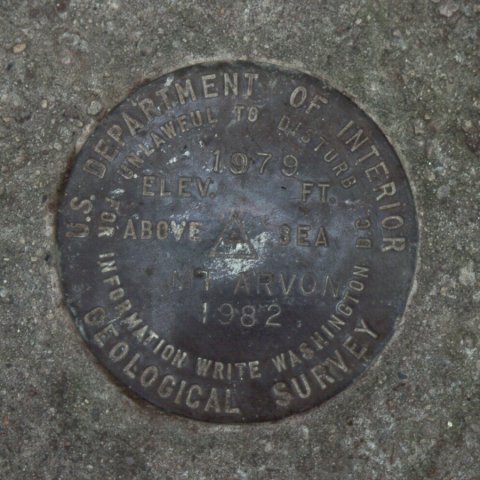
Mount Arvon (1,979'), The Michigan High Point
back
|
The highpoint itself is rather nondescript, at the crown of a gentle
rise. As is evident from the photos, it is heavily wooded, as is much
of the surrounding area. What it lacks for grand vistas is more than
made up for by the adventure of finding your way from known and
documented roads along a winding maze of logging roads, many of which
have been ill-maintained (if maintained at all!) over the years. The
GPS definitely came in handy on this one, keeping us from making wrong
turns at several points.
|

|
|
back
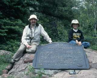
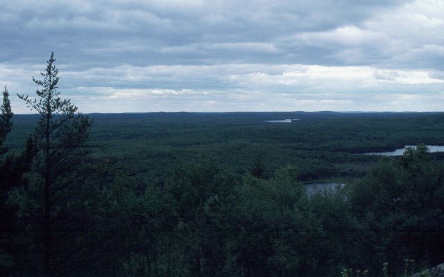
Eagle Mountain (2,301'), The Minnesota High Point
back
|
The high point, proper, is marked with this large plaque bolted to
one of the granite outcrops. In an area as heavily glaciated as
Minnesota was, only this very hard rock survived the bulldozer motion
of the ice.
The afternoon we hiked up Eagle Mountain, it was cloudy, and had been
drizzling on and off earlier, but stopped in time for our hike.
Temperatures were in the low 60's, perfect for an afternoon walk. The
only real downside (not surprisingly) were the swarms of the
state bird of Minnesota, the mosquito!! Liberal use of bug repellent
was certainly warranted.
|

|
|
The vantage point for this vista (one of the images which make
up the VR panorama) is a few hundred
yards from the summit, in an area where the granite outcrops on
the side of Eagle Mountain prevent the trees from completely
surrounding you. In the distance, you can see a few of Minnesota's
10,000 lakes. (Has anyone really counted them all to verify
that claim?)
|
|
back
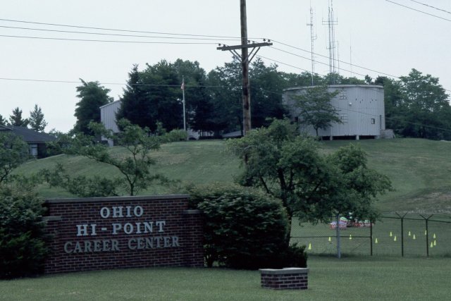
Campbell Hill (1,549'), The Ohio High Point
back
|
The campus containing the summit of Campbell Hill is marked with this
brick sign. The "Career Center" is a vocational school and teaches
such skills as cosmetology and auto repair.
The flagpole visible above the right-hand corner of the brick sign
is at the actual highpoint, atop the final slopes of Campbell Hill.
|
|
|
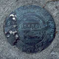
The Ohio high point is marked by this impressive flagpole, with the
USGS benchmark in the concrete and brick platform adjacent to the
base of the flagpole. This being a drive-up, Marcia got into the
act as she does on the easy ones, leaving the highpoints involving
significant hikes for Nathan and me.
|

|

|
back
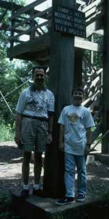
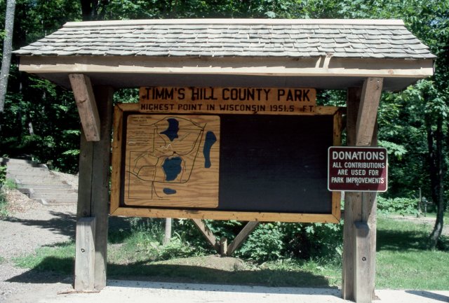
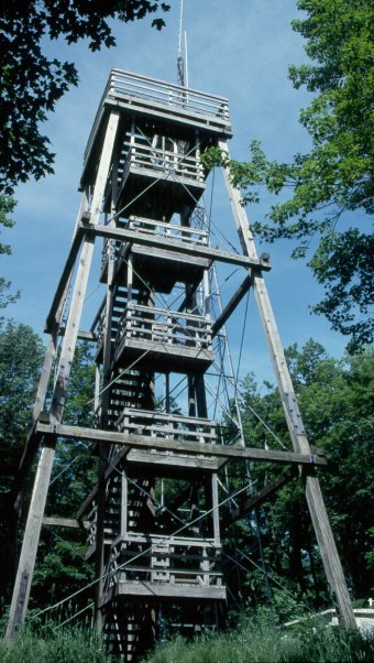
Timm's Hill, 1,951', The Wisconsin High Point
back
|
|
Timm's Hill is easily accessible within a county park. From the
parking lot, the easy trail winds perhaps 1/4 mile up to the top
of the hill. A slightly more rigorous climb will take you to the
top of the observation tower and afford you a view above the treetops.
If you follow highpointers' reports, you will note a suspicious
similarity in our photos of the tower from the base. There is only
a single spot from which you can see the whole tower through the
trees, so everyone has the "standard" shot of the tower!
|

|
|
|
The benchmark is inside the base of the tower, so is shaded
most of the day.
|
|
back
To file a trip report, please fill in the Report Entry form or contact the webmaster.