We met in Morgan Hill at 7:00 AM and carpooled to Fort Hunter Liggett. The stream crossing at Del Ventura Rd. was flooded with over a foot of water, and the gates were locked. But luckily the Lower Milpitas Road, which is not paved, was open and in good condition. We got to the trailhead near Indian Ranger station by 10:00AM. (See direction to the trailhead below.)
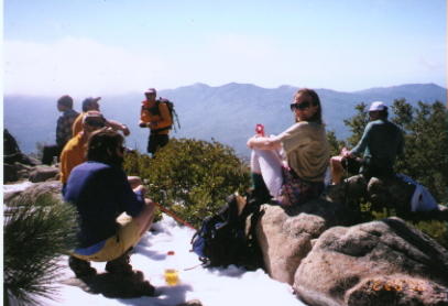
The trail was well marked and easy to follow. There were some creek crossings that required boulder hopping. and the flat parts of the trail were partially flooded. But considering all the rain we got in the last few month we could not complain. The trail called Santa Lucia Trail starts fairly flat for the first couple of miles, then climbed steeply to a saddle on the western ridge of Junipero Serra Peak. There, a spur trail leads East to the summit. Although the guide book warned us about the possibility of snow on the summit, I was surprised that it started a good 500 ft. from the summit, and was up to a foot deep in places.
We spent a good hour basking in the sun and exploring in the summit area, and then headed back down. A few of us were running low on water. I had carried 2 quarts with me, but I drank it all. I guess we were somewhat not prepared for the nice, warm weather. Luckily, Steve Eckert was on his "getting in shape" binge, and was carrying 3 gallons of water as ballast. He pretty much emptied his ballast into our water bottles. This should serve as a warning to anyone attempting this peak. Carry water, a lot of water.
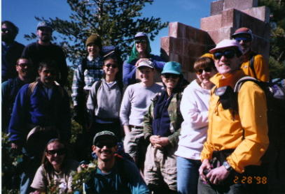
Participants: Ron Karpel (Leader), Joan Marshall, Tim Kutzcha, Nancy Fitzsimmons, Dan Tschler, Ted Raczek, Anh Duong, Steve Eckert, Aaron Schuman, Mark Godecki, Rich Calliger, Arun Mahajan, George Van Gorden, Richard Vassar, Ahmad Zandi.
Direction to the trailhead, by Arun Mahajan:
From 101, 1 Mile north of King City or 105 miles south of SJ, take
the Jolon Rd exit. Proceed 16.8 miles to Mission Road. Turn on Mission
Road, pass Hunter Liggett Mil Res. checkpoint Drive 5 miles to the intersection
with Del Ventura Road with a sign for Santa Lucia Memorial Park. Turn left
on Del Ventura Road which becomes Milpitas Road. Cross a creek after 0.3
mile and another after 7 miles on the DV Road. 10 miles after the second
creek, is the trailhead, marked by the Santa Lucia Trail sign on the right
side of the road near a 10mph sign. Turn right on the small dirt road there
to a parking lot.
A lot of detail of the trail itself can be found in the Calif. County Summits by Gary Suttle. I bought it at REI.
Numbers to call: (In the 408 area code).
Los Padres National Forest office in King City (385-5434) and the
"Range Control" office at Fort Hunter Leggett (386-2403).
The second number was the one that gave me better information.
Author Notes:
To use Lower Milpitas Road, do not turn left on Del Ventura Road, continue
North on Mission Road pass the Mission. The pavement stops and the dirt
road begins. Stay on the main dirt road until it tees with the paved road
which is Del Ventura to the left and Upper Milpitas Road to the Right.
Turn Right and continue to the trailhead.