Pilot Knob (South)
Revised Nov 2007 - please send updates to the webmaster
GENERAL NOTES:
There are rumors that the USFS is planning to create real public access to the south end of the Domelands Wilderness via the Bloomfield Ranch, but they expect to need a couple of years to implement it. In the meantime, get permission before crossing private land - and keep in mind that some people have said being part of the Sierra Club may make it hard to get permission in this area.
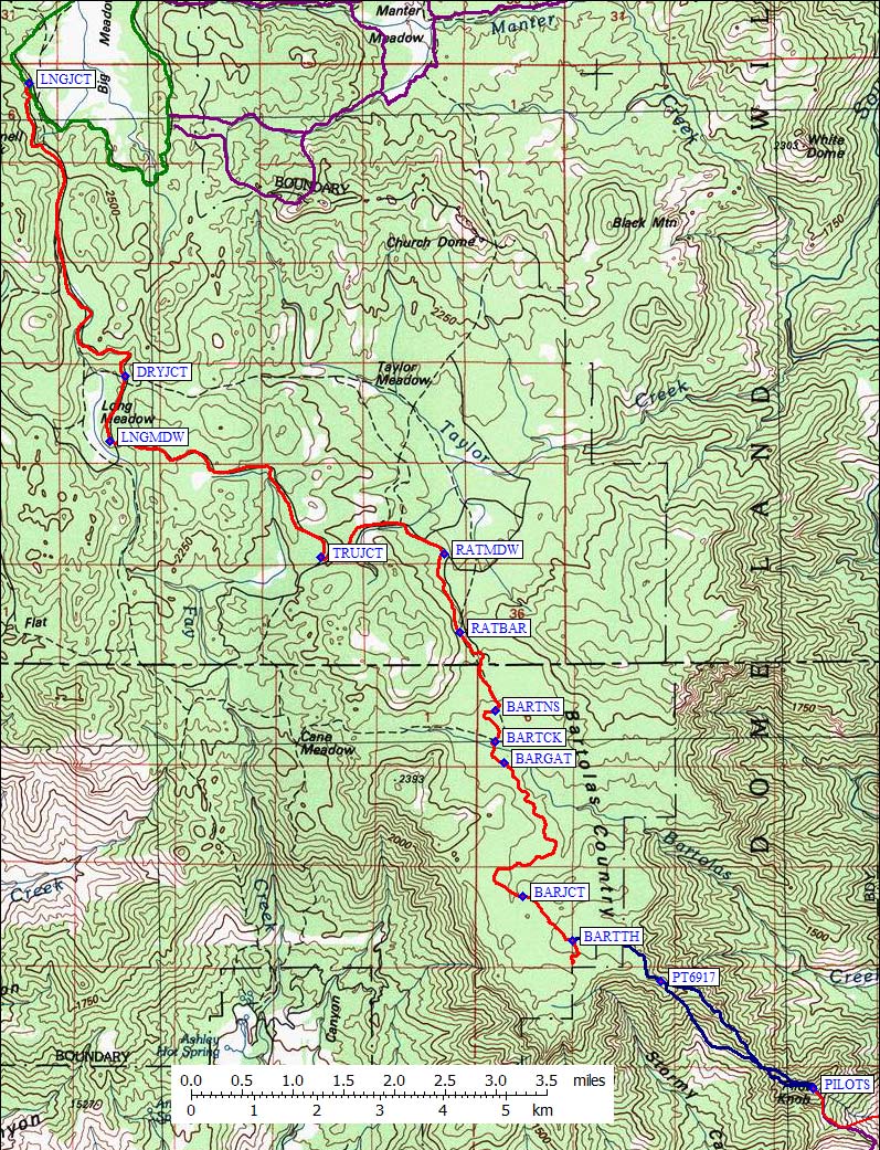
Driving route map (red line) - see also climbing route map
Follow the directions to Big Meadow, turning
south from the Sherman Pass road
on Cherry Hill Road (Forest Service Road 22S12 at waypoint BIGJCT) and drive
11.5 mi to Big Meadow. Prior to reaching Big Meadow the road becomes entirely
dirt at Poison Creek, but is in good shape for passenger cars. Instead of going
to any of the Big Meadow trailheads, bypass the meadow on the west (waypoint BIGMDW)
and continue south from waypoint LNGJCT on Cherry Hill Road, turning left where
there is a sign for Cannell and Taylor meadows.
At waypoint DRYJCT, continue straight south following signs for Cannell and Taylor.
(Dry Lake is not marked as such on the USGS maps, but is apparently Lake 7797.)
The main road junction at Long Meadow is waypoint LNGMDW, where you should turn
left (go southeast) following the sign to Taylor Meadow. At waypoint TRUJCT
(near True Meadow) turn left (northeast) following the sign for Bartolas Country.
At waypoint RATMDW (Rattlesnake Meadow on the USGS map) the road gets dramatically
worse and passenger cars are not advised. There is no sign visible at RATMDW
but you should turn right and climb to the saddle (waypoint RATBAR) which leads
south of the meadow to Bartolas Creek.
Driving south through Bartolas Country, be sure to continue south (straight)
at waypoint BARTNS where a deeply rutted road heads east on the north side of
Bartolas Creek. Cross the creek on a small bridge at waypoint BARTCK, continue
south to the next creek crossing (waypoint BARGAT) where there is an open steel gate.
If the gate is closed, you're still within reach of the peak but it will be a
longer walk on easy terrain! (Note: The total distance from waypoint LNGJCT at
Big Meadow to this gate is 11.9 mi.) The road continues south, without significant
elevation change, until the unmarked junction at waypoint BARJCT. Turning right
here will take you south on USGS map road toward Bartolas Point. Continuing
straight on the more well-worn road (which was not on our USGS map but was
in the Jenkins guidebook) will take you southeast over a slight saddle,
through an almost imperceptible drainage (which has good trees to camp in),
and slightly up onto more open terrain.
Park somewhere near waypoint BARTTH, at around 7000', before the road begins to climb.
This is not so much a "trailhead" as it is an efficient place to start
traversing around the north side of Point 7146 (which is brushy on top) to reach
Point 6917 and the northwest ridge of Pilot Knob (S).
See Daryn's trip report
for climbing details of this route, which appears to be undocumented or unclimbed prior to 2007.
There are no trip reports using this trailhead!
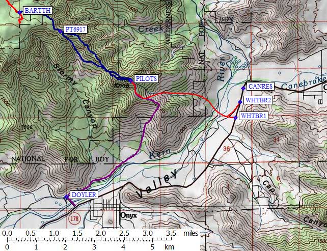
The land immediately east of White Blanket Ranch is (as of 2005) the
Canebrake Ecological Reserve, where a Public Access Trail starts at a
legal parking area (waypoint CANRES). There are no markings visible
from Hwy 178 other than a sign on the green metal fence reading
"please close gate behind you".
The reserve does provide access to land on the southeast side of the
South Fork Kern River, there is as yet no bridge across the river.
The trail is bordered by fences indicating it is illegal to leave the
trail. It's not clear if the public land extends to the river or not.
The unsigned gated entrance to the ecological reserve (waypoint CANRES)
is about 0.2 miles west of the Bloomfield Ranch Road.
The trail itself goes north along the river and crosses a small
side stream, it does NOT seem to provide any access to Pilot Knob
unless you want to ignore the plentiful signs and jump a couple
of barbed wire fences so you can crawl through the brush to a
river you cannot see from the trail.
The standard route to Pilot Knob (the red line on the map below)
starts at White Blanket Ranch (2700', waypoint WHTBR1),
which has a private bridge across the South Fork Kern River.
To get to the starting point, find Call Box 178-659 on Hwy 178,
a couple of miles east of the village of Onyx. Right beside the call box
is the entrance to the White Blanket Ranch itself (waypoint WHTBR1).
This private road is gated and signed "no trespassing" but
at least part of the time the gate is not locked.
About a half mile in on the driveway, there are two trailers.
This is the White Blanket Ranch, home to Josephine, Frank and their daughter.
They were friendly and gave permission to cross their land.
Josephine didn't ask for money, but we gave her five bucks because
we wanted to make sure that hikers would continue to be welcome there
in the future. If you follow these directions, please remember to also
follow our example and tip the ranchers. Josephine asked that we
write her in advance, at PO Box 376, Onyx CA. Enclose a self
addressed stamped post card.
Rather than parking on the highway near the gate, or driving through
the gate, there is a dirt road (waypoint WHTBR2) about halfway between
waypoints CANRES and WHTBR1 which parallels the Canebrake Ecological Reserve
boundary fence. From the end of this road you can hop
a fence and walk down a dirt road which shortly angles/merges into the main
dirt driveway to White Blanket Ranch and across the South Fork of the Kern.
This may be a less intrusive method to cross White Blanket Ranch and reach
the trailhead, but you might want to ask the White Blanket Ranch folks where you
should park and where you should cross when you're asking permission to enter.
At least one group has climbed Pilot Knob from the property of Ben Rudnick,
on Doyle Ranch Road (waypoint DOYLER, following the purple line on
the map below). This is the only public access bridge across the
South Fork of the Kern River. From the north end of the bridge, follow
the river northeast through gated ranchland until you enter a bowl and
attain the SE ridge of Pilot.
Useful Links:
Northern Approach - public land, no permit or permission needed!
This route was first climbed by Daryn Dodge and Steve Eckert in 2007,
trying to find a good alternative to the private-land southern approaches
which had gotten Pilot Knob suspended from the DPS list. A detailed map
and description of the climbing route is in
Daryn's trip report.
(GPS Routes BARTOLAS COUNTRY and PILOT KNOB NORTH)
Southern Approaches - all cross private land, permission is required but not always given!
(GPS Route PILOT KNOB SOUTH is from the northern approach,
look for waypoint BARTTH)