Grapevine Mountains
(Corkscrew, Thimble, Palmer, and Grapevine)
Revised 3 Dec 2014 - please send updates to the webmaster
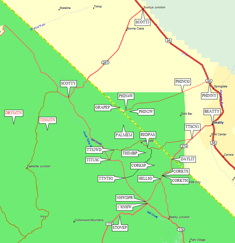
These four peaks are all in the Grapevine Mountains, but separated by Titus Canyon. That means hours of driving to get between the trailheads covered in this file (pullouts near Corkscrew and Titanothere, or Phinney Canyon for Grapevine and Palmer).
To get to any of these trailheads, take your favorite route to Stovepipe Wells in Death Valley
(waypoint STOVEP), then take Hwy 190 (which is also Hwy 178)
northeast to the junction with the North Hwy (waypoint 178NHW, where 178/190
turns south to Badwater). Turn left (northwest) on North Hwy, then continue to
Titanothere Canyon or turn right (northeast) toward Daylight Pass
(waypoint NHWDPR). Follow the Daylight Pass Road
to CORKTH for the boring standard approach to Corkscrew,
or go over the pass, through Beatty, and use the dirt road up Phinney Canyon
(from waypoint PHINNY) for Palmer and Grapevine.
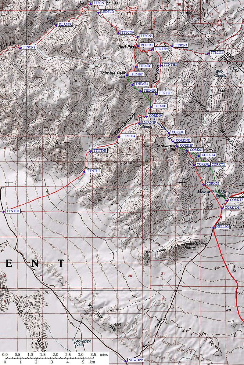
If you stay on North Hwy to the mouth of Titanothere Canyon (waypoint TTNTH1),
you can climb both Corkscrew and Thimble from a great dry camp near Lost Man Spring.
Another option for Corkscrew and Thimble is to drive the Titus Canyon 4WD road
(waypoint TTSCN1) to the head of Titanothere Canyon
(waypoint TTNTH9), but you can't spend the night on the one-way Titus Canyon Road.
Corkscrew and Thimble are both Class 2, and are typically climbed from a road
(paved for Corkscrew, Titus Canyon 4WD for Thimble). Titanothere Canyon provides
an easy approach to alternate routes on each peak, and you may want to consider
dry camping in the canyon rather than dayhiking them.
(Titanothere
fossils were found in this canyon but I doubt you'll see any.)
From the Daylight Pass road, Corkscrew is an easy dayhike with interesting rock formations to look at.
(Screwtop would be a more appropriate name.) Some of the DPS mileages seemed to be wrong for Corkscrew.
Find Hell's Gate (a sign board at a junction, waypoint HELLSG) and go north
to the first turnout on the west side of the pavement. The standard DPS starting point
(waypoint CORKTH) is next to a 20' bank, which you scramble up to start your climb.
This route is in red on the map. A short distance toward Daylight Pass there is an official trailhead sign
(waypoint CORKTS) and a sometimes-faint trail (in green) all the way to the summit.
Via Titanothere Canyon, you can climb both Corkscrew and Thimble.
Go to the Daylight Pass Road junction (waypoint NHWDPR) from
Stovepipe Wells or Furnace Creek, then go about 8 miles northwest on the North Highway
to an unmarked pullout (waypoint TTNTH1)
near the center of the alluvial fan south of Titus Canyon.
It doesn't matter much where you park, the alluvial fan is wide and the washes
are numerous and it's four miles cross-country to the mouth of Titanothere Canyon.
The canyon is easy walking and connects to Titus Canyon road if you go past the peaks.
Via Titus Canyon, you can park at Red Pass (waypoint REDPAS)
for a very short climb of Thimble. From further east (waypoint TTNTH9)
you can drop from the Titus Canyon 4WD road into Titanothere Canyon to reach the west side
of Corkscrew (in blue on the map). Remember you can't camp in Titus Canyon!
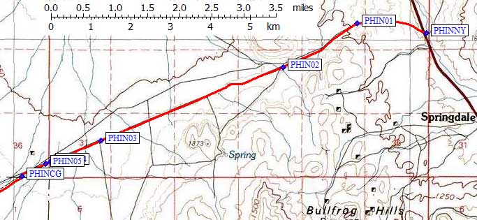
Take Hwy 95 north from Beatty, and turn west on the dirt Phinney Canyon Road
(waypoint PHINNY). The DPS Guide says it's 0.6 miles north of Milepost 71,
but doesn't say there's another road with an identical gate very nearby.
The CORRECT road crosses the highway, forming a 4-way intersection,
but is unmarked. Use your GPS to be sure, since there are many roads
not on the map (which are not mentioned in these and other directions).
Phinney Canyon Road has a barbed wire gate near the pavement which you must go
through and close behind you. There is no sign indicating whether that's OK.
The dirt road (suitable for passenger cars at this point) goes mostly west
for about a mile, then turns southwest. Ignore all the instructions you've
seen elsewhere about this fork and that fork - just drive in a straight line
through intersections at waypoints PHIN02-08. You will encounter a sharp
dogleg and cattle guard at the Death Valley boundary (waypoint PHINCG),
7 miles from Hwy 95.
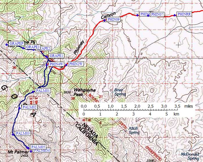
Keep going straight until waypoint PHINRF, where you take a right fork
about 12 miles from Hwy 95. Almost 16 miles from Hwy 95 the road gets rougher
(waypoint PHINRR). High clearance is enough, without 4WD, but passenger cars
will be challenged by ruts and rocks beyond here. There were several vague
forks, where we stayed right to avoid leaving the Phinney Canyon drainage,
before we dropped into the wash itself.
In March 2008 there was so much snow we had to stop (in a Jeep) almost a mile
down-canyon from the 2WD trailhead. That means the waypoint for the 2WD trailhead
at 6800' (waypoint PHIN2W) is approximate.
If you have a solid GPS waypoint, please send it! (Yes, we used snowshoes to
walk up the road - the narrow portions of the canyon had 3-4 feet of snow - and
yes, we got both peaks.)
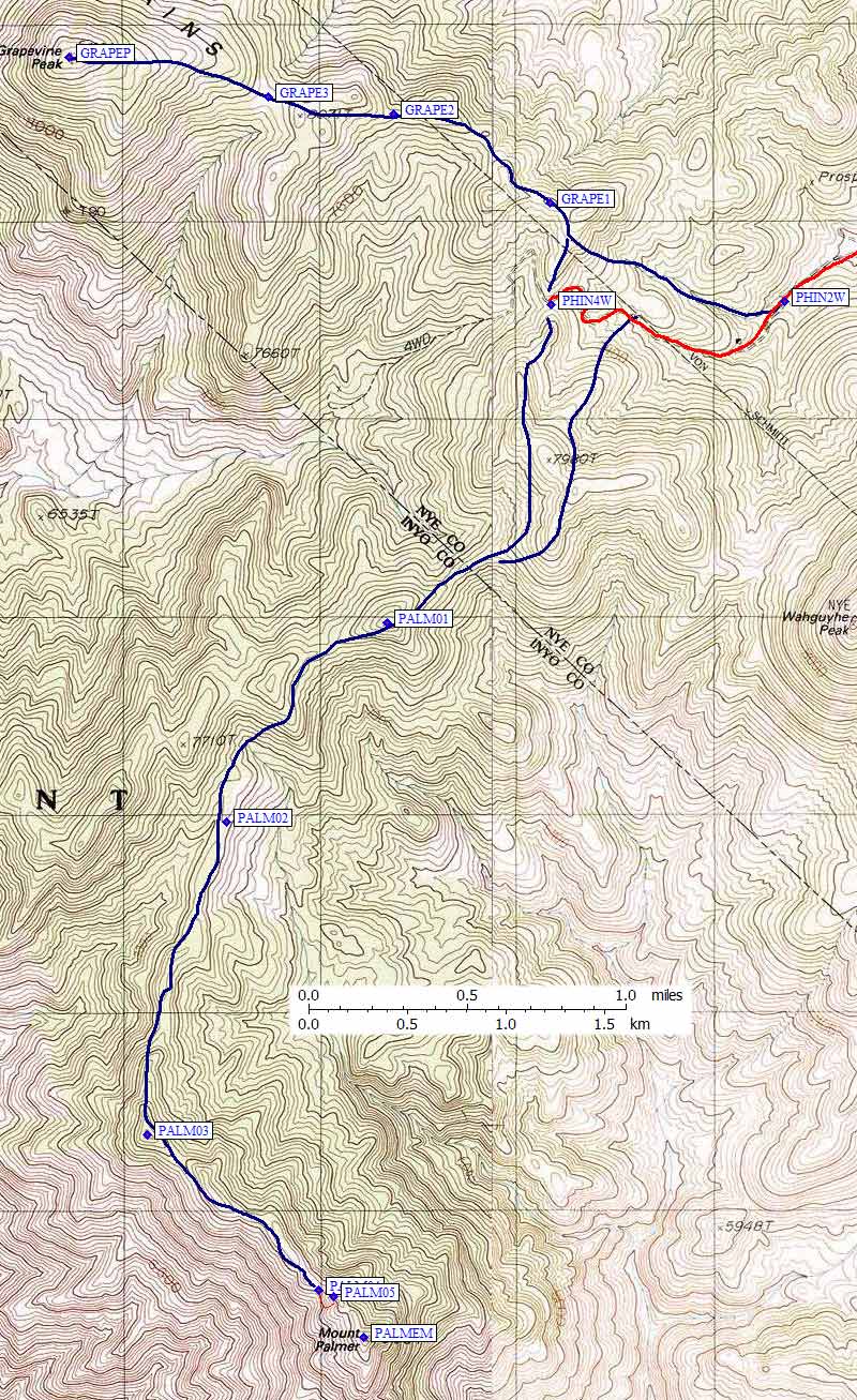
Those with 4WD and high clearance can drive just under a mile and about 700'
higher to the saddle at 7500' (waypoint PHIN4W). I can't comment on how bad
the road gets because I didn't see any of it under all that snow.
Useful Links:Overall map: (detailed maps for
Corkscrew, Thimble,
Grapevine, and Palmer are below)
Corkscrew and Thimble details:
(see area map above,
plus Steve's 2008 and 2014 trip reports)
Grapevine and Palmer details: (see area map above, and Daryn's trip report for Grapevine and Palmer)