Glass Mountain
Revised 26 Jun 2014 - please send updates to the webmaster
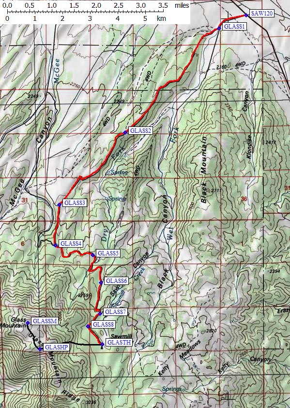
Glass Mountain is an easy dayhike, perfect for conditioning on
the way to somewhere else. The trailhead (waypoint GLASTH)
at the Sawmill Meadows Campground is a surprisingly nice place with tall trees and
picnic/outhouse facilities but no water. The peak's register is on the
high point (waypoint GLASHP),
not the named summit (waypoint GLASSM).
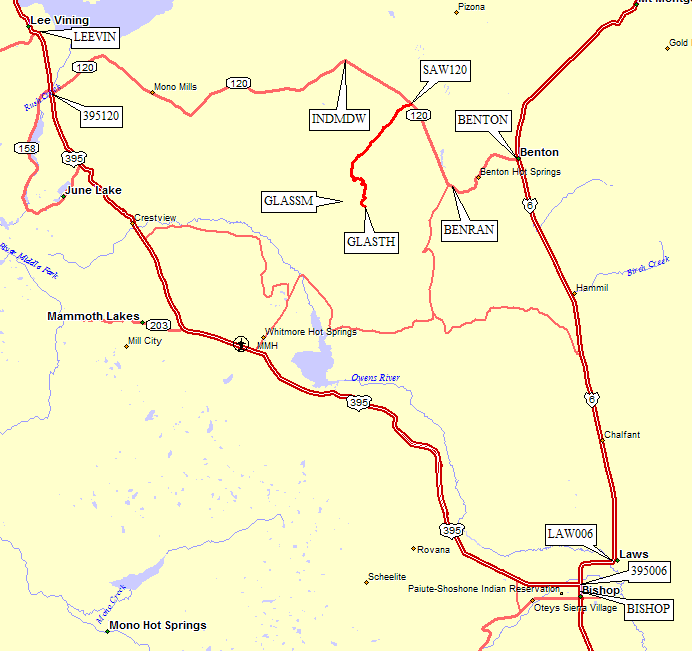
There are several ways to get to the Sawmill Canyon turnoff from Hwy 120 (waypoint SAW120):
- GPS Route BISHOP TO BENTON follows Hwy 6 north from Hwy 395.
Starting in Bishop (waypoints BISHOP and 395006, with a jog over to
Laws (waypoint LAW006), stay on Hwy 6 north to Benton (waypoint BENTON),
then head west on Hwy 120 to waypoint SAW120.
The Benton Range (waypoint BENRAN) is a nice place to watch a sunset!
- GPS Route LEE VINING TO BENTON follows Hwy 120 east from Hwy 395.
Starting in Lee Vining (waypoint LEEVIN), take Hwy 395 south 5 miles
to the junction where Hwy 120 goes eastward from Hwy 395 (waypoint 395120)
then go east on Hwy 120 to waypoint SAW120.
- GPS Route GLASS MOUNTAIN leads you south from Hwy 120
(waypoint SAW120)
to the trailhead (waypoint GLASTH).
- I don't recommend it, but you can also take Benton Crossing: from the green
church just south of the Mammoth Airport go around Crowley Lake and over
a pass near the Wildrose Mine before reaching Hwy 120 just west of
waypoint BENRAN.
Everyone can drive to the trailhead/campground:
It's a good dirt road from waypoint SAW120 to GLASTH,
suitable for all vehicles. In 2014 the sign at the turn-off from
Hwy 120 for Sawmill Meadow (waypoint SAW120)
had been replaced with a sign for Black Canyon Road... and the
only trick is to be sure you turn right at waypoint GLASS1
about 0.7 miles from the pavement, where Black Canyon goes straight and
Sawmill Meadows is a somewhat unexpected right angle turn.
The campground at the trailhead was no-host and no-fee when I was there.
Overall map: (see detailed topo map below)
Useful Links: