Red Lake and Birch Lake
via McMurry Mdw
Revised 30 Jul 2015 - please send updates to the webmaster
See this popup local area map showing Big Pine south to Lone Pine (look for waypoints BIGPIN and 395FSR).
View the waypoint file (above) for GPS Routes BIG PINE-BIRCH,
BIRCH-MCMURRY, MCMURRY-REDLAKE,
TINEMAHA-REDLAKE, and HWY 395 BIG PINE TO LONE PINE.
Do NOT trust directions that say to take the first or second fork of any road in this area. There are lots of roads on the ground that are not on the maps and descriptions, and I have a feeling that more will be beaten into the desert scrub as time goes by.
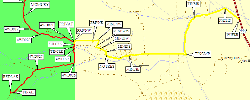
Here's an overview map with most of the waypoints removed for clarity:
- Standard/Legal Route to both trailheads: Big Pine, Crocker Rd, Glacier Lodge Rd, McMurry Meadow Rd
- Alternate Route to Red Lake, may NOT be legal: Fish Springs, Tinemaha Campground, pit mine, skirt private land
|
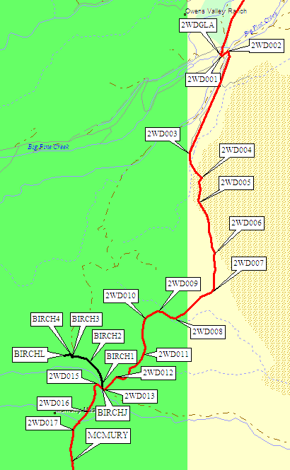
NOTE: The North Fork and South Fork Big Pine Creek
trailheads are accessed by going to the end of Glacier Lodge Road,
staying on the pavement at waypoint 2WDGLA,
and are not covered by this trailhead page.
Ā The red line from BIGPIN to REDLAK is the standard route to Red Lake and Birch Lake. It took us almost an hour to drive out on the dirt road from the Red Lake trailhead in daylight and with exact knowledge of the turns, and close to twice that long to find our way up to the trailhead in the dark. You can get to McMurry Meadows in a passenger car, just before dropping DOWN to Fuller Creek on the way in (which is uphill and the most nasty stretch on the way out). Beyond Fuller Creek you need real 4WD with good clearance. Waypoints change from 2WD to 4WD where the road changes. Matt Greg pointed out in 2003 that you can skirt the fence along private land (yellow line on the map) and take a shortcut if you have lots of ground clearance, but we bottomed out repeatedly in a Subaru trying that route in 2005 (before giving up, so we don't really know how bad it gets). Also, going uphill you do have to drive past a No Trespassing sign - there's no gate, but it's not clear whether the GPS route 'MAYBE LEGAL' actually steers completely clear of private land. I wouldn't recommend it, unless you fail to get up the hill going out on the standard route and have no other options. | 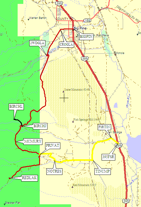
|
|
NOTE: Near Fuller Creek (the south side of McMurry Mdw, 6300') a tempting road
leads due south (at 4WD019), but dead ends in a sandy hill just short of
Tinemaha Creek. Going part way up this road is the best you can do in a 2WD car,
and most 4WDs spin out in the sand if they go too far.
You can climb down to the creek and walk a mile south to the trailhead
from here, but it's tedious and I don't list any waypoints for this option.
Here is Bob Davey's description of this or a similar route in 2015: |
Here's the 4WD road, from McMurry Meadows to the Red Lake Trailhead:
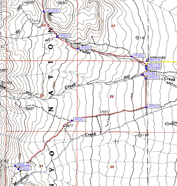
There is one really bad spot on the way out that doesn't seem so bad on the way in. It's uphill along Fuller Creek on the way out, between waypoints 4WD020 and 4WD021. You have to be brave and take a bit of a run at in a Subaru, but except for that spot moderately high clearance is just fine and 4WD is not really required on the entire road.
The correct road continues downhill TO THE EAST from waypoint 4WD019 following Fuller Creek through the really bad spot until you hit private property at about 5500' elevation (waypoint PRIVAT). A right turn takes you south across Fuller Creek (waypoint FULCRK) and Tinemaha Creek (waypoint TINCRK) and almost to Red Mountain Creek until you can turn right again (at waypoint 4WD026) and climb southwest about 2 miles to the marked Red Lake trailhead at 6500' (waypoint REDLAK).
The last choice you have to make gets a lot of people! Near the trailhead there is a tempting final road junction (waypoint FINALJ) with a trailhead sign and parking. From this sign there is a nice trail that leads you across Red Mtn Creek and up to Stecker Flat. This is the WRONG WAY!
Park where they tell you, but walk over to the spring (marked by a stand of willows) at waypoint REDLAK, then switchback up the hill on a sandy trail. It starts switchbacking directly up the east facing slopes, traverses south, and then stays hundreds of feet above Red Mtn Ck, on the NORTH bank. Secor refers to a rocky outcropping, but you won't see it on the way up - it's where the trail turns west.
The trail is said to be poorly maintained, but it's easy to follow except near the stream fork at 7600', where a use trail lures you to the south side on the way down. Resist! The north side trail is the one and only righteous way! If you're fighting through brush, you've lost the trail and you should go back to find it. Water is scarce except near the stream fork, because the trail stays high on the dry sunnny side of the canyon. Good campsites start at about 10k, below which there are few trees, and continue up to Red Lake. The view of Split from Red Lake makes the few extra minutes of walking well worth it!
Dave Johnson adds mileages, as of 1999:
This was my first trip to the Red Lake trailhead. I found it to be fairly easy and straightforward. The rangers at the White Mountain Ranger Station in Bishop grossly exaggerated the road condition. We did the trip in a Ford Explorer, never using 4WD. The only other car at the trailhead was a Honda Accord! They went slow and used some 4x8's to bridge gaps. I wouldn't recommend this, but any vehicle with high clearance should be able to make it with few problems. Stream crossings could be more difficult in the early season, however. There is a creek crossing with a 12" pipe across it that we almost bottomed out on. (probably Fuller Creek, waypoint FULCRK) I found Steve Eckert's 1999 description of the road to be very accurate. I'd allow 1 hour for the drive from Big Pine. Here's my description of the road in:
Going uphill on this route you DO drive past a No Trespassing sign,
and the trailhead directions from Inyo National Forest state clearly
that beyond the campground is private land and you are asked not
to trespass. There's no gate, but it's not clear whether the GPS
route TINEMAHA-REDLAKE actually steers completely clear of private
land. I wouldn't recommend it, unless you fail to get up the hill going
out on the standard route and have no other options to get out.
Source: Matt Greg (quoted by Sid Rao in 2003, maps/waypoints and comments in italics by Steve Eckert in 2005)
I bailed out on this hike at Red Lake a few hours after getting there on
Saturday because I was worried about being able to drive out and make it to work
on Monday. My 2WD Chevy S-10 would not have made it back up the grade mentioned
above without a tow. Because I had minimal clearance from the rocks on this
stretch of road I was worried that a tow could damage my truck. The USGS topo
map of the area shows many other roads in the area that appear to be more direct
routes from Hwy 395 to the Red Lake parking area. Problem is, all but one of the
routes is gated and locked private property with posted no trespassing.
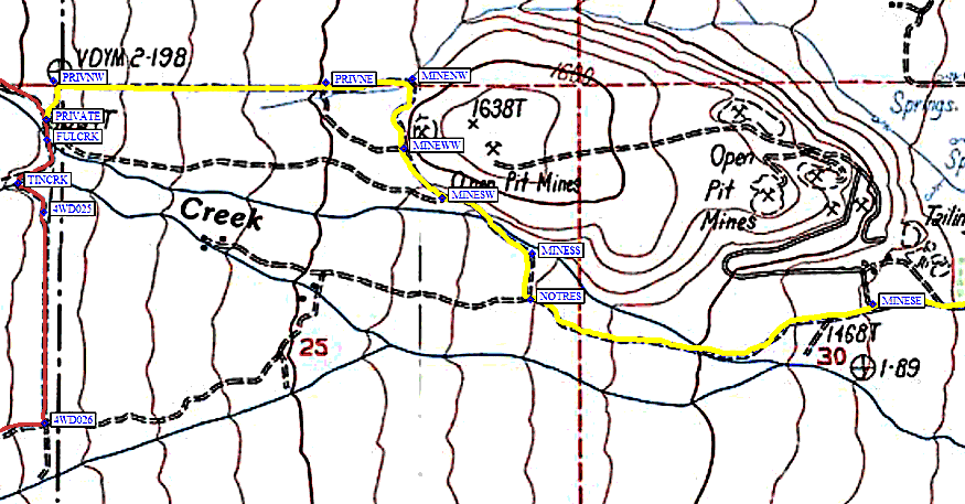
See the image below for the route I found. (the yellow line on the map)
The route DOWN is as follows, see below for how to find your way UP:
From the trailhead parking (waypoint REDLAK) head down the road a
few hundred feet to the large sign on your left (waypoint FINALJ) and
make a right here. In maybe 100 yards or so there is a junction with a road to
the right (waypoint 4WD027). Stay left here. Eventually the road you
are on will deadend at another road at 90 degrees (waypoint 4WD026).
On the opposite side of this road is a fence and gates with no trespassing signs.
To the right, this road deadends. Make a left here and follow parallel with the fence,
due north. Cross Tinemaha Creek (signed, waypoint TINCRK). This is
the larger creek, with a concrete catch basin. Continue north and cross Fuller
Creek (waypoint FULCRK) which is smaller and sometimes has an exposed culvert.
When you come up the other side of the creek, there is a 3-way junction
(waypoint PRIVAT). The road to the right deadends in a couple hundred
feet at private property. The road to your left takes you back along the
standard route described above (toward waypoint 4WD021).
Take the third option - straight on a very rocky road that first heads north along
the fence, then turns (at waypoint PRIVNW) with the fence and follows it due
east (to waypoint PRIVNE). Take it easy and slow on this very rocky road. The
rocks are mostly rounded but large and well seated in the ground. This road does not
require 4WD as there is only a slight grade, but it does require high clearance.
My Chevy S-10 pickup was about the minimum clearance that you could take on this
road with some careful driving, it has about 7.5 inches of ground clearance.
Continue along the fence toward the base of the hill in front of you.
Stay off the sandy roads on your right (near waypoint PRIVNE, where the
fence turns south but you continue east to avoid a wash). Continue
following the rocky road to the base of the hill (waypoint MINENW)
and then to the right (south) around the west nose of the hill
(waypoint MINEWW). At this point the road is graded dirt
(not rocky!) and gets better as you head out. Follow this same road
around the base of the hill (waypoints MINESW, MINESS, NOTRES)
saying off the roads to the right which head back up and deadend at
private property. The road you are on eventually passes through the
main mining area (waypoint MINESE). Stay on the main road
and follow it out (east), it is wide and graded. It eventually
becomes paved as the USGS map shows. Just past Tinemaha campground
you will make a left on the paved road (waypoint TINCMP) and
follow it to its end at Fish Springs road (waypoint FSRTIN).
Make a right here and go a short distance back to Hwy 395 (waypoint 395FSR).
You are now a few miles south of Big Pine.
Steve Eckert adds details for going IN this way:
Here are details of the dirt roads around private land:
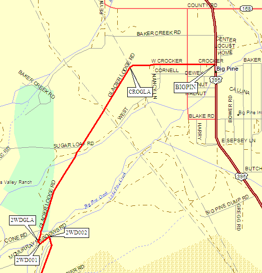
About 7.5 miles south of Big Pine is a junction with Fish Springs Road.
(There is another junction 2.7 miles north of this junction, but you want the
southern one, right where Tinemaha Creek crosses Hwy 395, waypoint 395FSR.)
Follow Fish Springs Road northeast to waypoint FSRTIN, where you turn
right on the signed Tinemaha Creek Road. Follow this paved road southeast
and then south to the Tinemaha Campground (waypoint TINCMP), where you
turn east and go right through the campground. Now you're on Fuller Road.
Continue east on a road that is at first paved and later good dirt,
past the open pit mine entrance (waypoint MINESE). Roughly 2.5 miles
from the campground you will come to a 'No Trespassing' sign
(waypoint NOTRES) that says there are locked gates ahead. If you
turn north here, and thread through a maze of little roads via
waypoints MINESS, MINESW, MINEWW, and MINENW, you will be going
between the mine and the fenced private property. That doesn't mean
you're legally driving on a public road. It just means you don't
drive through a locked gate. You did drive past a 'No Trespassing'
sign, which Matt didn't see on the way down because it faces the
other way. Caveat Emptor.
From waypoint MINENW, northwest of the hill that they're mining,
turn due east on what is now a bad dirt road. At waypoint PRIVNE
you will pass the northeast corner of the fenced private property.
(If you are in a sandy wash, you turned east too soon - go back to
the base of the hill and follow the road just north of the wash.)
In 2005, in a Subaru, we found the 'road' that parallels the north
fence to be more of a cross-country route, and we bottomed out
several times before turning around. It's only about half a mile
along the fence, to waypoint PRIVNW, but as Matt said you do need
more than 7 inches of ground clearance to do this bit!
From waypoint PRIVNW, turn following the fence to waypoint PRIVATE,
where you join the standard route described above (going southeast
up the hill to the trailhead at waypoint REDLAK).
Useful Links:
Alternate Route, may NOT be legal: see waypoints for TINEMAHA-REDLAKE
(Hwy 395, Fish Springs, Tinemaha Campground, pit mine, skirt private land)