Southern Panamint Range
(Wildrose, Telescope, Sentinel)
(Porter, Manly, Needle)
Revised Jan 2012 - please send updates to the webmaster
The Panamint Range forms the western side of Death Valley. In the north are Dry and Tin, near Towne Pass are Canyon Point and Panamint Butte. The high point of the range is Telescope Peak (rising over 11000' from below sea level in Death Valley). The southern end of the range contains two pairs of very different peaks: Porter and Sentinel are over 9k (a real snow climb in the winter) between Pleasant and Surprise Canyons, while Manly and Needle are near Mengel Pass (a serious 4WD road from the west and a long drive from the east).
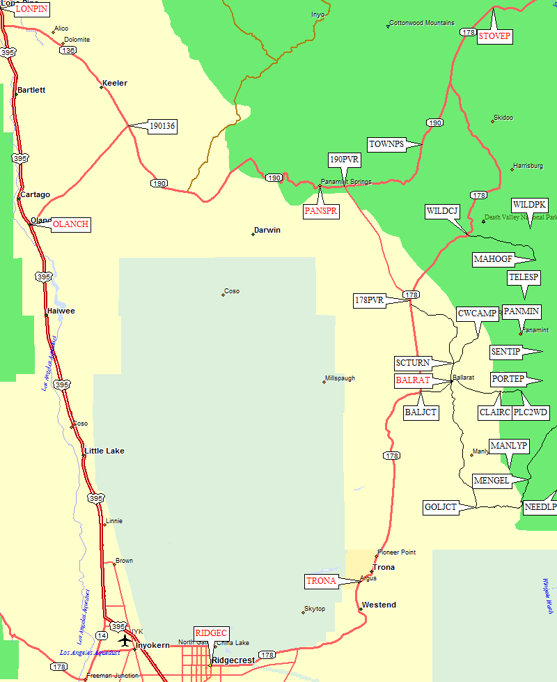
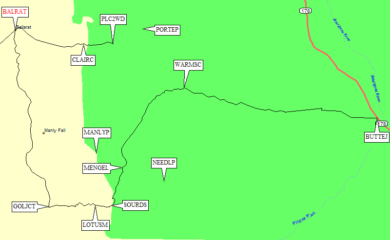
Southern Panamint trailhead areas are clustered around Ballarat (a ghost town, waypoint BALRAT), between Trona and Panamint Springs. To get to any of them, you need to be on Hwy 178 between Ridgecrest (waypoint RIDGEC) and Stovepipe Wells (waypoint STOVEP). This part of Hwy 178 is roughly parallel to Hwy 395 but on the other side of the China Lake Naval Weapons Center. Hwy 178 gets very narrow and poorly maintained north of waypoint 178PVR, where the far superior Panamint Valley Road connects to Hwy 190 (at waypoint 190PVR).
Ballarat (waypoint BALRAT, 3.6 miles from Hwy 178) is a store where you can get cold drinks, but no food as of Feb 2010. There is a "campground" (or gravel parking area) near the store which costs $2/night (same price for Bud or soft drinks at the store) and is a somewhat permanent home for miners working just south on Wingate Road. To avoid the crowds and the fees, just drive north from Ballarat on Indian Ranch Road and look for wide spots to pull out.
Area Map: see below for detailed maps of the trailheads:
Wildrose Canyon, Surprise Canyon, Pleasant Canyon, and Mengel Pass.
Drive north on Hwy 178 from the Panamint Valley Road intersection (waypoint 178PVR) on good pavement.
Almost 6 miles from 178PVR there is a yellow gate (waypoint WCGATE)
that can be used to close lower Wildrose Canyon, but it was
open in Jan 2012 and there was no indication under what conditions it might be closed.
The road gets much narrower at the gate, and the pavement is very deteriorated with some
large potholes and stretches where the road is just gravel. Higher in the canyon there are
springs which produce sheets of ice in the winter.
The intersection of Hwy 178 and Wildrose Canyon Road (waypoint WILDCJ, 9.6 miles from Panamint Valley Road)
can be confusing because Hwy 178 turns sharply just south of this intersection and then turns again at
the intersection. The map makes it look straight, but it's actually a 90 degree right turn when
going uphill. There is another gate just south of this intersection, again with no clues
as to when or if it might be closed. Hwy 178 continues north up Rattlesnake to Emigrant Pass (EMIGPS)
on the way to Stovepipe Wells but I don't know what condition the road is in.
Just east of Hwy 178 on Wildrose Canyon Road is the Wildrose campground, which may require a fee.
A quarter mile from the intersection is the Wildrose Ranger Station (waypoint WILDRS),
the first building you come to on the south side of the road.
The station seems to no longer be staffed - maybe in summer?
The pavement improves greatly above the Ranger Station, but 5 miles from the WILDCJ intersection
there is a pullout/turnaround and the pavement ends (waypoint WILDPE). The road is well maintained
but rocky gravel which gets steeper, looser, and larger as you continue toward Mahogany Flat.
The Charcoal Kilns (waypoint CHRKIL, 7.2 miles from the WILDCJ intersection) are a major attraction.
This parking lot, with a very clean outhouse and prominent No Camping signs, serves as the
The Thorndike Campground (waypoint THRNDK) is just under 8 miles from the WILDCJ intersection,
under a mile from the end of the road, and is a good place for passenger cars to park.
It features a very clean outhouse, tables, fire rings, and no fees (at least in winter)!
In Jan 2012, I could have driven to the top in a passenger car except there was ice on the road.
A small parking area is just outside the upper entrance to the campground.
There are more campsites at Mahogany Flat, which unlike Thorndike has a great view,
in addition to Telescope Peak trailhead parking (waypoint MAHOGF). The trail to Telescope
Leave Hwy 178 at the Ballarat junction (waypoint BALJCT), drive almost to the store
(waypoint BALRAT), and turn left at the campground sign. If you miss this sign,
turn left in front of the store and you'll end up at the same place... on Indian Ranch Road
going north from Ballarat. RVs park at pull-outs all along this road, apparently once you
are beyond the obvious "improvements" around Ballarat it's all free camping.
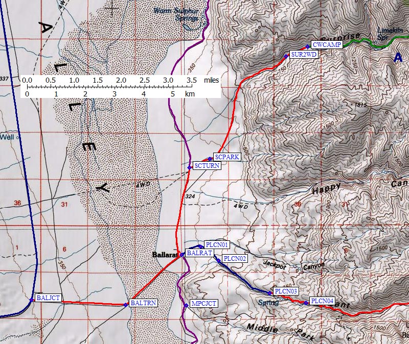
Turn right (east) to Surprise Canyon at a white boulder (waypoint SCTURN,
5.5 miles from the pavement). There is no sign, just that out-of-place rock.
It is possible to continue north around east side of dry lake (past Warm Sulphur Springs)
to reach Hwy 178 further north at waypoint 178IRR, but it's worse road and going
through Ballarat is faster.
Soon after SCTURN, you'll see a long parking area first on the south side of
the road and then on the north. Camping and parking for a virtually unlimited
number of vehicles continues to waypoint SCPARK, 6 miles from the pavement,
above which the road narrows but remains easy for passenger cars.
9 miles from the pavement and 0.5 mi from the end of the road (waypoint SUR2WD)
is where passenger cars should park. Beyond there the road gets steep, loose,
rocky, and there are clearance issues. There is no place to turn around after
SUR2WD, you would have to back down if you spin out or high center.
In Jan 2012 my sedan made it without dragging, but it's loose and could get
rutted easily from one or two crazy 4WDers.
The Surprise Canyon road ends 9.5 miles from Hwy 178 at what the USGS map labels
as Chris Wicht Camp (waypoint CWCAMP), a large parking area by the ruins of some
buildings and a running stream. Fight your way up the brushy slot canyon and the
"surprise" is that the canyon opens up just before Panamint City, the ruins of
an old mining operation. Above the slot you're walking on a road, and waypoint
SOURCJ is a fork: left to Sourdough Canyon (and The Castle, an old cabin with
running water) or straight to Panamint City (and The Hilton, a newer cabin
that's being maintained by volunteers). A foot path connects Sourdough to
Panamint without going back down to fork.
Frenchman's Canyon road comes out into Panamint at waypoint PANMIN
between large stone building and steel frame shed, just up the canyon
from The Hilton. There is no longer a real road or even a clear trail,
but you can get to Panamint Pass quite easily and down the east side
of the range to Hungry Bills and Johnson Canyon.
Leave Hwy 178 at the Ballarat junction (waypoint BALJCT), drive straight past the store
(waypoint BALRAT), following a hand-painted sign
saying that Pleasant Canyon is straight ahead. The road up Pleasant Canyon starts
off a bit rocky, but was OK for my passenger car. At the first branch (waypoint PLCN01)
take the right of several choices. This was not the best looking choice!
With care, I drove a sedan into the canyon (waypoint PLCN02) and up to what
I'd call the passenger car trailhead (waypoint PLCN03, 2100'). There is a small
parking area above which the road steepens considerably and climbs 200' before
narrowing along a brushy stream. In some places, especially when snow is melting,
the road IS the stream. In other places the brush is 10' high and obviously
trimmed into vertical walls by passing vehicles.
The road is rocky but not muddy even with running water (soil seems very stable).
2WD should be OK if high clearance, but water or mud may make traction a problem.
Somebody pulled a 5th-wheel trailer up to Clair Camp, so how bad can it be?
At waypoint PLCN04 a side road goes off to left, apparently joining one of the
road forks from PLCN01. I've heard that the road may be gated at Clair Camp
(waypoint CLAIRC, 4500') but I didn't see a gate and vehicles were driving
through the camp in 2010. The snow line was 4500' when I was there,
so I can't say whether it was 2WD or 4WD beyond that, but I could have
gotten to Clair Camp with a high clearance 2WD pickup or a Subaru.
There was a vague junction at 5400' (waypoint PLCN07) where I stayed left.
This junction (unlike the one at PLCN06) is not on the map and may have
just been a wash covered with snow. I think I saw big cat tracks here.
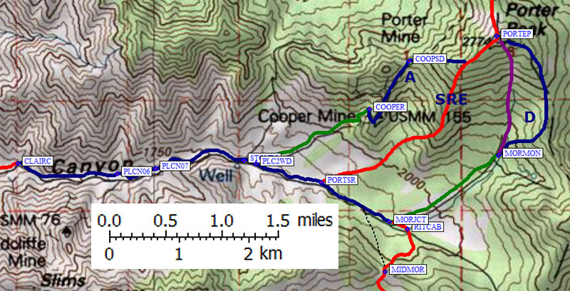
Near the Stone Corral label on the USGS map there is a junction to the
Porter Mine at an NPS boundary sign (waypoint PLCN08). Just over a tenth
of a mile later is the DPS Guide's 2WD trailhead (waypoint PLC2WD, 6000')
at the junction to the Cooper Mine.
Stay right at PLC2WD if you're headed for Mormon Gulch and the SE ridge
of Porter, go left if you're headed for Cooper Mine and the SW ridge of Porter.
The Cooper Mine 4WD trailhead (waypoint COOPER, 7000') appears to leave
you with tougher terrain than the Mormon Gulch trailhead.
At the drainage south of Cooper Mine (waypoint PORTSR, 6200') there is a
minor fork. Take the right fork to continue to Mormon Gulch, or walk east
from here to reach the south ridge of Porter on an all-year cross-country route.
Continue up Pleasant Canyon almost to 6400' (waypoint MORJCT) and turn left
(northeast) to reach the Mormon Gulch 4WD trailhead (waypoint MORMON, 7000').
I don't know if the road is open in the summer, but in 2010
I went over a 6800' pass (waypoint MIDMOR) from Rita's Cabin (waypoint RITCAB) by taking the left fork
just beyond the Mormon Gulch fork. It seems that this road is drivable in the
summer, but since it was under 3' of snow when I was there I'd appreciate
comments from someone who tried it. If it's open, the road goes across
Middle Park and over another small ridge to South Park, where it ends at the
edge of Butte Valley (overlooking Willow Springs and Mengel Pass).
I used this route (on snowshoes) to climb Needle in February.
This route is south of Ballarat (waypoint BALRAT), which is about halfway between
Trona and Panamint Springs. See the Pleasant Canyon directions for how to reach Ballarat.
I'll provide a map and waypoints here, but NO DETAILS because I haven't driven this
road in many years.
WARNING: I've heard from many people that they won't drive over Mengel Pass ever again.
One famous DPS climber had to jack up his rented 4WD and push it off the jack to get
unstuck there. On the other hand, the only time I've been over Mengel Pass was in a
2WD Ford Ranger with a madman at the wheel.
We had to stack a few rocks into the bad spots, and he was completely airborne once
(with me watching safely from the sidelines), but we didn't get stuck and we made it
up the west side and down the east side without 4WD or extreme clearance. It's a much
easier drive from the east, but it's interesting that both the western and eastern
approaches are from Hwy 178!
Wildrose Canyon - Passenger car access to Wildrose and Telescope
Wildrose Peak trailhead. There is yet another gate at the kilns, which I presume is closed when
there is heavy snow on the road. All vehicles can get to the Kilns easily.
goes up the east side of the ridge, the gated road to the radio towers on Rogers Peak goes
up the bowl on the other side of the ridge. You can go the other direction and run the
ridge out to Wildrose Peak, which is straightforward navigation with easy footing
but there is no trail most of the way.
Surprise Canyon - 2WD access to Sentinel and Porter, possibly Telescope
Pleasant Canyon - access to Porter and Sentinel
(and cross-country access to Manly and Needle via Middle Park and South Park)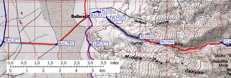
Mengel Pass - Tough 4WD access to Manly and Needle
|
gjerstad adds in July 2010:
I went over [Mengel Pass] last fall in a Jeep Wrangler.
The link below goes to a video of a path through the tough spot on the way
into Butte Valley. The toughest part is at about 0:53 to 1:05 in the
video. I followed the same route in my Jeep without much difficulty. I've
seen Jeeps go up the pass, but the drivers looked experienced. I went down
the pass and out Warm Springs Canyon Road to the West Side Road in Death Valley.
See the YouTube Video. |
Useful Links: