Palen Pass Area
(Big Maria, Palen Mtn, Granite Mtn South)
Revised 29 Mar 2014 - please send updates to the webmaster
Palen Pass is north of I-10 between Desert Center and Blythe. This is a land of little ranges and big washes, and even if you've gotten your high-clearance 2WD vehicle to all the other trailheads you'll have trouble with some of these. My perspective is biased because I was there DURING a huge storm, in which fresh sand washed over the roads completely obscuring any signs of wheeled travel and leaving deep mud. When it's dry I'm sure some of the roads are better but I'm also sure that summer traffic will create soft sand pits waiting to trap unsuspecting 2WD or AWD vehicles. Big Maria has the easiest driving of these peaks.
Area Map: see below for detailed maps of the trailheads:
Granite Mtn South, Palen Mtn, Big Maria Mtn.
Exit I-10 at Desert Center (waypoint DESC10, east of Joshua Tree). This exit is marked for Hwy 177 and and Rice Road, but Desert Center is a sad ghost town full of dead palm trees and shanties. No services here! Drive 17 miles northeast on Hwy 177, then turn right (east) on the dirt road to Palen Pass (waypoint 177JPP). The DPS Guide says this is a sandy road, but I have not approached Palen Pass from this direction so please let me know what it's like if you've been there recently.
1.8 miles east of Hwy 177 there is a right (south) turn (waypoint PALPAL) to climb the west side of Palen (from waypoint PALATH), or go straight for Palen Pass (waypoint PALPAS). Granite can be climbed from either side of Palen Pass (waypoints GRNATH and GRNBTH), and going over the pass gets you access to the east side of Palen (waypoint PAL4WD) and on to Big Maria (waypoints BIG2WD and BIG4WD).
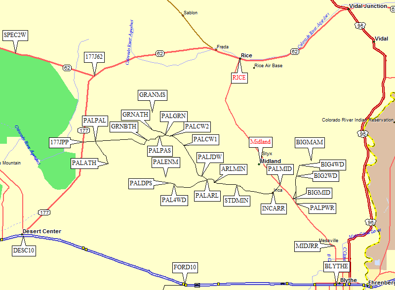
Exit I-10 at Lovekin Blvd in Blythe (waypoint BLYTHE). Blythe is just west of the Colorado River, and big enough you can find gas and groceries (unlike the dismal Desert Center). Big Maria is on the way to Palen Pass, Palen Mtn is a side trip from near the Arlington Mine, and Granite Mtn South is at the pass.
Go north 5.5 miles on Lovekin Blvd to the railroad crossing (waypoint MIDJRR) where the pavement bends, crosses the tracks, becomes Midland Road, and climbs into sediment piles. 14 miles from I-10 the pavement crosses under a power line (waypoint PALPWR) which the DPS Guide says to follow to Big Maria, but a better place to turn off for Big Maria is a mile later behind a Public Lands sign (waypoint BIGMID).
17.6 miles from I-10, all on good pavement, turn left (west) onto a dirt road (waypoint PALMID) at a white and black sign saying Standard Mine. There are actually two separate dirt roads, parallel to each other, both called Arlington Mine Road. It doesn't matter which you take, they join just before the railroad crossing. Cross the railroad and jog south (left then right) at the abandoned Inca railroad station (waypoint INCARR) and continue west. The road is great here, wide and suitable for all vehicles, but not for long! As you leave this area, there's another white and black sign saying Standard Mine 7 mi.
NOTE: The town of Midland is 4.2 miles past the PALMID junction, but I'm not sure if there are any services. When I was there the road was closed due to flooding and mud, but the paved road from Blythe just goes to Midland. In better conditions you can continue to Hwy 62 and the town of Rice on a 4WD road over the Maria Mtns and through the Rice Valley.
7.2 miles from Midland Road, about 25 miles from the freeway, there is yet another white and black sign, this one saying Standard Mine 2 mi. Follow Arlington Mine Rd as it goes left (waypoint STDMIN) and becomes smaller. The obvious main road goes right to the mine. This junction is NOT on the USGS maps, but it is obvious in Google Earth. Continue west, and soon the road is no longer maintained. There are serious washouts which passenger cars might be able to get by depending on recent rain activity, but it's not a good idea to continue without high clearance.
10.6 miles from Midland Road (waypoint ARLMIN) turn right (north) following the sign for Arlington Mine Rd. There is no sign for the road going straight, but it leads to the Arlington and Black Jack mines, both at the north end of the McCoy Mountains. Half a mile later the road bends west again.
12 miles from Midland Road there is a junction sign for Arlington Mine Road and Palen Pass Road (waypoint PALARL), but the arrows are missing! Continue west on Arlington Mine Road to Palen Mtn, and you will soon see a sign for Patton's Cabin on a stake with a tire around it. Turn right (northwest) for the road which goes 10 miles to Palen Pass and Granite Mtn.
North of Arlington Mine Road, the Palen Pass road goes across a series of washes and erosion cuts with deep sand, then follows streambeds northwest. No more 2WD, even with clearance, unless conditions just happened to be perfect. My trip was muddy and deep, lots of traffic would make this fluffy when dry. A little over 13 miles from Midland Road there is a sign for Palen Pass Road at a junction in the dry wash (waypoint PALJDW). Go northwest, not north, continuing to cross washes instead of driving up them.
The road here can change daily depending on rain, becoming an unpredictable combo of mud, sand, and gravel. From 3-5 miles from PALARL there was no sign of ruts or tire marks, just bank-to-bank streambed sand! It's hard to know if you're on the road going downhill after a storm, because the stream forks are indistinguishable from informal road junctions. Again, these were the conditions during and after a big rain storm, but in the fall there are probably very clear tracks to follow.
18.3 miles from Midland Road, the Palen Pass road crosses a sharper wash (waypoint PALCW1). There are signs on both sides so you don't get lost and drive up the wash itself. After that it climbs up on gravel rib, no mud here, and 40mph doesn't feel too fast. At 20.8 miles there is another bad wash crossing, with serious water damage to road wash (waypoint PALCW2).
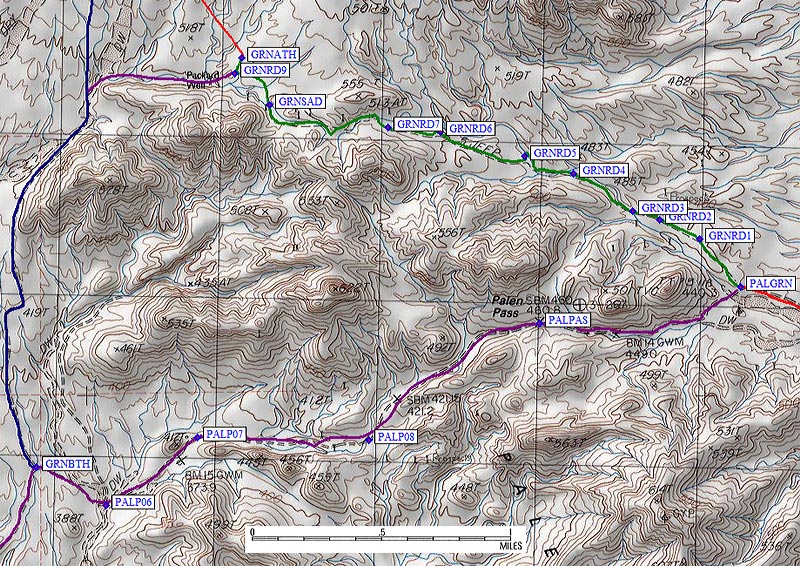
21.6 miles from Midland Road there is a sign directing you to turn left for Palen Pass (waypoint PALGRN). It's almost a mile west to the pass, then 2.3 miles down the west side of the pass to the "Route B" trailhead (waypoint GRNBTH). To reach the trailhead closest to Granite Mtn, "Route A", keep right (continue northwest) and drive 2.3 tough miles to waypoint GRANATH.
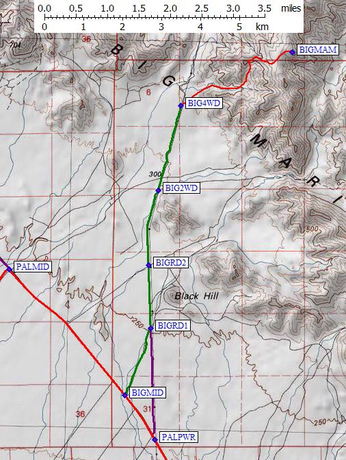
| 14 miles from I-10 on Midland Road the pavement crosses under a power line (waypoint PALPWR) which the DPS Guide says to follow to Big Maria. That works, but a better place to turn is a mile north, behind a Public Lands sign (waypoint BIGMID). It's better road and the dirt part is shorter. | |
|
See overview map for context. No part of this road (in green on this map) is really suitable for passenger cars! Join the power line access road 1.2 miles from the pavement (waypoint BIGRD1). There is a sign here which directs you west to Midland Road on the way down. Follow the powerline north past Black Hill. You'll cross another dirt road 2.2 miles from the pavement (waypoint BIGRD2), which is where I'd recommend leaving 2WD vehicles. Above this there are washouts the road climbs up and down to get around. The road bends slightly east just before reaching the DPS Guide's 2WD trailhead (waypoint BIG2WD) 3.5 miles from the pavement. A tenth of a mile after BIG2WD there is a sign that says Midland-Vidal Road in our direction. There are lots of bad stretches between BIG2WD and BIG4WD, and I'm guessing they change yearly with traffic and erosion. I stopped 4.9 miles from the pavement (waypoint BIG4WD), two tenths of a mile before the DPS GUide's trailhead and just uphill from power pole 46-5. There was flat ground to camp on under the power lines, I didn't want to fight my way through the last wash in a rental Jeep Patriot, and the terrain looked better. (Here you walk up a nice firm gravel ramp, there you have to boulder hop.) See my 2010 trip report for details. |
|
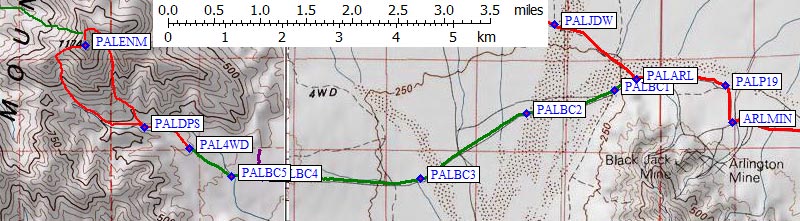
The McCoy Mountains are the prominent lump when driving on the Palen Pass Road.
To get around the north end of McCoy, follow the Palen Pass
directions from Blythe. At the junction sign for Arlington Mine Road and
Palen Pass Road (waypoint PALARL), continue west on Arlington Mine Road.
Soon after the intersection you can confirm you're going the right way by
following a sign for Patton's Cabin on a stake with a tire around it.
A quarter mile later (waypoint PALBC1) there is a fork with another
stake with a tire around it but no signs - stay right to go east rather
than following the McCoy Mountains to the south.
See overview map for context.
NOTE: There is no longer any such thing as a 2WD trailhead for Palen, since
getting past the Arlington Mine requires both clearance and traction.
2WDs should stop back by the sign with a tire around it,
because even if you have good clearance the sand/mud means you need 4WD.
For the next couple of miles you are basically crossing a huge plain perpendicular
to the water flow, one cross-cut stream after the next. After a big storm, there
can be some steep drops into active washes and there can be some deep mud puddles.
As you climb due west up the lower slopes of Palen, stay on the main road and ignore
any forks or intersections. There are some really nasty sections where there is
a good road beside the rocks you drive on (but the good road is blocked off by
berms and boulders for some reason). This is slow rocky driving.
There are a couple of wilderness signs 4.4 miles from Palen Pass Road
(waypoint PALBC4) and a tempting road that goes north but leads nowhere.
Continue west to the biggest and toughest wash (waypoint PALBC5), 4.7 miles
from Palen Pass Road and 16.7 miles from the paved Midland Road.
In 2010 I had to get out several times and move a bunch of HUGE rocks here.
There was no visible vehicle route in the wash, perhaps because the big
storm had moved material down the canyon. Go more or less straight across
this gray gravel wash studded with notably pink boulders, then nothwest
up a steeper slope to the trailhead. Matt Hengst
reports in late 2013
"There are two routes out of the wash. There's one straight ahead that had a jeep ramp built up with rocks and a clear one to the right that is significantly easier. They both go the same place."
17.3 miles from Midland Road is the trailhead for climbing the east side
of Palen Mtn (waypoint PAL4WD). I'm calling this the 4WD trailhead even
though the DPS Guide calls it a 2WD trailhead because I don't think 2WD
vehicles can make it here, but let me know if I'm wrong! The DPS Guide
4WD trailhead is now off limits and can not be legally driven to.
Park where the road turns left and loops back down the hill (waypoint PAL4WD,
at 1.3k). There is a wilderness boundary stake and the old road above here
has been intentionally littered with rocks. Of course there is a track going
around the blockage, but it's clearly illegal! It's not a great place to tent
camp (rocky) but there is plenty of parking along the road and there's a
really great view of the McCoy Mountains.
See my 2010 trip report for details
on both Route B and Route C, which I did as a loop. The square concrete structure
the DPS Guide mentions can only be seen briefly from one short stretch of the
4WD road, looking over your left shoulder, so this is not a good landmark!
21.6 miles from Midland Road, and 0.8 miles before the pass, there is a sign
directing you to turn left (southwest) for Palen Pass (waypoint PALGRN).
Driving over the pass to climb Route B (from GRNBTH, 3 miles west of PALGRN
on the Palen Pass Road) is an option, but these directions assume you want to
drive as close as possible to the peak and that's the Route A trailhead (GRNATH).
See overview map for context.
Stay to the right (northwest) at PALGRN, then stay left 0.1 miles later on a good
road that winds through piles of white mine tailings. Go over a minor pass near
the tailings pile (waypoint GRNRD1) 0.25 miles from the Palen Pass Road. From here
to the trailhead, you're trying to follow a canyon northwest. Most of the time
you'll be on the side of the canyon, some of the time you'll be in it. It would
be an adventure to drive the entire wash, or if you don't have a good 4WD you
might want to walk the wash.
GRNRD2 is a vague fork 0.4 miles from Palen Pass Road - stay left on the way in.
This is a good place to consolidate vehicles on the way in because the driving
gets much tougher. Drop into a wash (waypoint GRNRD3), jog right, then leave the
wash on your left. This is not yet the tough wash. GRNRD4 is a fork in the road
where you'll need to stay right on the way out, 0.8 miles from Palen Pass Rd
or 1.7 miles from the trailhead.
Enter the worst wash of this road 1 mile from Palen Pass road. Turn right and
drive north along the wash for a tenth of a mile, then basically do a u-turn
and climb very steeply out of the wash heading south (waypoint GRNRD5).
Matt Hengst
continued
up this wash rather than turning left, and although it does not go through or connect
to the road again, you can walk to the peak from where you have to stop driving.
The wash looks far better than the road climbing out, but is soon blocked with
boulders and trees. The DPS Guide describes this as the place where you go 200'
up a wash, but their first exit is totally washed out and you must go a bit up
the wash for left exit mentioned above. On the way out, make a 90 degree left
turn just before GRNRD5, then immediately drop down steeply into the big wash.
There is a road that goes straight, but it goes straight over the edge with
the bottom is washed out.
Above the tough wash the driving gets easier for a while. At GRNRD6 cross a
boulder-strewn shallow wash, then climb awah from the canyon onto a side slope
where where sharp ravines frequently cut across road (starting at GRNRD7).
These dips all got deeper and sharper during the storm I sat out, and I had
to shovel rocks and gravel into the bottoms to avoid scraping front and back
of the Jeep!
Finally you reach a gentle saddle 1.9 miles from Palen Pass Road (waypoint GRNSAD).
If you're worried about flash floods in bad weather, this is the place to camp and
park. If not, continue 0.2 miles down toward Packard Well and turn right on a
smaller track (waypoint GRNRD9) to the Route A trailhead (waypoint GRNATH at 1.7k).
It appears you could keep driving right past Packard Well and down the wash to
the Route B trailhead (waypoint GRNBTH at 1.2k), but I didn't do that and I'd
love to hear from anyone who has driven this way. It might be an easier approach
to the Route A trailhead, or the road may be closed down at the Route B trailhead.
It's tricky to pick an efficient route across the washes and boulders into
the correct drainage for Granite.
See my 2010 trip report for details
and climbing waypoints.
Useful Links:
Palen Mtn (from the east)
Granite Mtn (South)