Montara Mountain
Revised 25 Dec 2017 - please send updates to the webmaster
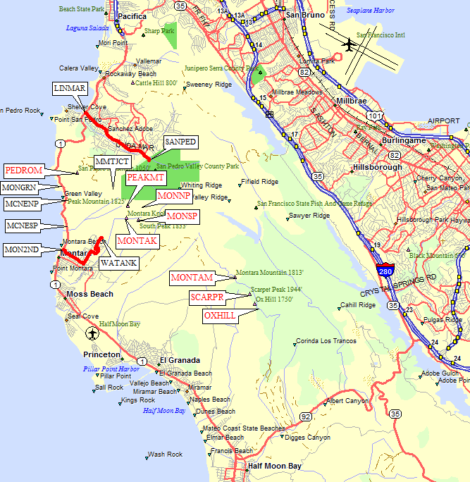
Montara Mountain (like the town of Montara itself) is south of Pacifica and north of Half Moon Bay, on the coast. This file points you to four trailheads for the peak most people refer to as 'Montara Mountain' - but see below for a better description. This file does not contain details of every trail in the area, just some of the trails I like the best, and the trailheads I know about!
The 'mountain' itself is almost a range, and the peak most people are heading for is properly called 'North Peak'. The true Montara Mountain (as labeled by the USGS) is three miles southeast (as the crow flies) and inaccessble due to permanent SF Watershed closures. North Peak is 1898 ft high, the point named Montara Mtn is only 1813', and the high point is Scarper Peak at 1944'. Some maps label Scarper as 'Scarpet', but as Keith Mangold pointed out the only name in the USGS database or on USGS maps is Scarper!
GPS route MONTARA PEAKS has waypoints representing the labels shown in red below, other waypoints are for reference (see the topo map above for more). The GPS waypoint file has full peak names and elevations for each peak. Note that the three southern peaks are inaccessible due to watershed restrictions.
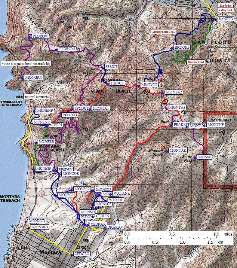
Leave Hwy 1 at the north end of the city of Montara, across from the Montara State Beach parking area.
Look for 2nd Street (waypoint MON2ND, a few blocks north of the filling station and inn), turn inland for
one block to Main Street, and jog one block south to continue inland on 3rd Street (waypoint MON3RD).
3rd becomes George and intersects Cedar (at waypoint CEDGEO) - make a left on Cedar and go uphill
to Drake (waypoint CEDRAK). Follow Drake to the right, then turn left on Alta Vista (waypoint DRAKAV).
Alta Vista turns into a dirt road as it switchbacks up onto a narrow ridge, then follows the ridge
north past some water tanks.
Immediately above the water tanks is an unmarked 4WD road (waypoint WTRAIL)
that drops steeply but leads you to gentle trails that end up at McNee Ranch.
See 'Montara to McNee' for details of this trail. Continuing north about a
tenth of a mile, the road ends at waypoint WATANK and a good trail leads directly
up the ridge to a peak labeled 'Peak Mtn' (waypoint PEAKMT) on the USGS maps.
(Oddly enough, the USGS benchmark at the top of Peak Mtn says 'Pedro', but
that inconsistency is left for others to investigate.)
This is the shortest way up the mountain from any direction, which means it's
also the steepest, but it's not unreasonably steep.
This route takes you on trails that may require permission if approached from the other way,
but there are no signs at the trailhead or along the trail. See 'McNee to Montara' for an
alternate that avoids signs posted where this route joins another route.
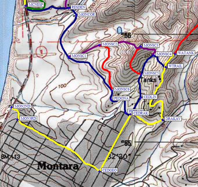
Park near waypoint WTRAIL, described above, go down the steep hill to
waypoint MONSC4, where you will find a number of intersecting roads.
The ones that go up-canyon are loops that dead end, the one that goes
down-canyon is the completely legal way to reach McNee, and if you
keep going northwest you'll end up on the knob marked by waypoint MONSC3.
(There is a junction at the top, and the southwestern road leads down
to wayoint MONSC5, not a useful detour.)
Follow the ridge west past waypoint MONSC2 (where a footpath traverses
over to MONSC6) and down to MONSC1 to complete the shortcut to McNee.
From here you turn right on an old (paved) road, going past farmland
on your left to the horse stables (waypoint MONCOR). Cross the bridge
to the caretaker's residence (wayopint RESDEN) where you can follow
the main road left to the McNee Ranch southern parking lot (waypoint MCNESP)
or stay right and follow the old road up to ROADTJ and join the
MCNEE S APPROACH route.
This route takes you on trails that do not require permission, avoiding the
shortcuts which are marked 'access by written permission only' from this direction.
See 'Montara to McNee' for a shortcut that avoids walking on roads.
Park near waypoint MCNESP, described below, and walk up the tree-lined
road to the caretaker's residence (waypoint RESDEN). Turn right and cross
a small bridge to go between the horse stables (waypoint MONCOR), then
follow the old road (which separates the farm fields from open space) past
two shortcut trails (waypoints MONSC1 and MONSC6). This road turns into
a residential street at the intersection of Pedro Mtn and Corona
(waypoint PEDONA), which winds a bit before joining Drake (waypoint PEDRAK)
just before Drake intersects Cedar (waypoint CEDRAK). You could park where
Pedro Mtn Rd is closed, but I much prefer parking up at waypoint WATANK
to avoid walking on city streets.
From waypoint CEDRAK, it's about a tenth of a mile up Cedar to the
Linda Vista road sign, where you can turn left onto a dirt road that
goes past waypoint MONSC5 to reach the bottom of the very steep hill
(waypoint MONSC4) up to the water tanks (waypoint WTRAIL). From here
you can follow the ridge up to Peak Mtn as described above.
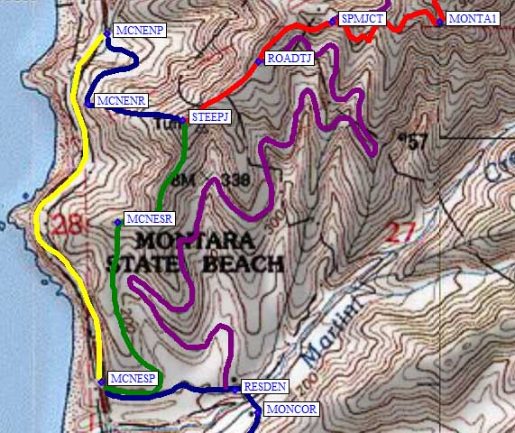
Go about halfway between Pacifica and Half Moon Bay on Hwy 1 (Pacific Coast Hwy).
Between the town of Montara and Devil's Slide you'll see a very small parking lot
labeled McNee Ranch State Park (a waypoint MCNESP) on the inland side of the
highway). This page refers to this as the 'South McNee' trailhead because there's
another lot less than a mile north of here. There's also a beach parking lot on
the west side of the highway, which is much larger but can be crowded and you
have to cross a busy highway and walk on a narrow shoulder to the McNee Ranch
parking lot and trailhead.
An alternate parking lot that has less cars and more room is at waypoint MCNENP,
about three quarters of a mile north of the other lot. As of 2004 there is a lot
of construction equipment parked here. At the south end of the lot is a small
trailhead and information panel. The trail from this lot is steeper but goes
to the same place as the steep trail from the southern lot.
You won't have to pay for parking at any of these lots, but signs say you can
only park there from 8am to Sunset. Mountain bikes are allowed on the old
roads, but not on most single track trails.
From the southern lot you have a choice of gaining the ridge and climbing
steeply on a single-track trail (shown in green), or wandering back and
forth on a lower incline abandoned road (shown in purple between waypoint
RESDEN, the caretaker's residence, and waypoint ROADTJ). The steeper
trail joins with the steep trail from the north lot (at waypoint STEEPJ)
shown in blue, and together they ascend the ridge to join with the old road
route at waypoint ROADTJ.
Once you're on the dirt road (shown in red) above waypoint ROADTJ you can
choose to go basically hold altitude and hike to San Pedro Mountain
(the purple line starting at waypoint SPMJCT), go over the shoulder onto
the north slopes and down to San Pedro Valley Park (the blue line starting
at waypoint MMTJCT), or stay up on the ridge and climb to North Peak
(the red line which represents the main dirt road). The peak has a couple
of radio towers near it, but if you follow the highest road you'll get to
a nice clearing with almost a 360 degree view (waypoint MONTNP).
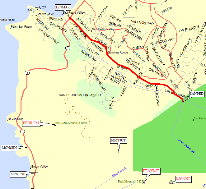
Turn inland from Hwy 1 on Linda Mar Blvd (waypoint LINMAR), and follow the signs to the
County Park. You'll have to pay for parking even if there's no one at
the kiosk. The phone number for the park is 650-355-8289. There are
self guided nature trails, a visitor center, picnic tables, and more
people than you can imagine on a nice weekend.
Head up the Montara Mountain Trail (shown in blue) directly from
the San Pedro Valley Park Visitor Center (waypoint SANPED), or go
via the Brooks Trail (shown in green, sort of near a brook) to
join the Montara Mtn Trail at waypoint BROOKS. Keep going up on
rougher trail to join the main dirt road (at waypoint MMTJCT) to
access North Peak or McNee Ranch parking areas.
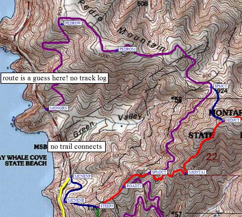
If you want a longer flatter hike than climbing to North Peak,
leave the eastern dirt road approach at waypoint SPMJCT for the
main trail junction to San Pedro Mountain (waypoint PEDROM).
This is another abandoned road, shown in purple. To make the route
more interesting you can take a narrow eroded somewhat overgrown
single track (shown in blue) from SPSJCT to HIDJCT - you will have
trouble finding the upper junction on the main dirt road to North
Peak because it's hidden by bushes and has no sign. It's steep but
not too wild as of 2004.
For even more excitement, you can drop off the west side of the mountain
into Green Valley. From wayopint PEDROW there is an abandoned road which
leads near the southern edge of Devil's Slide and down to Hwy 1 at
waypoint MONGRN. Unfortunately, no road or path exists across Green Valley,
and you can't park anywhere near the MONGRN waypoint (across the highway
from that eroded old building on a knob of rock). The route between
PEDROW and MONGRN is approximate, but it does exist as of 2004.
Useful Links:
City of Montara trailhead
(south side routes CITY OF MONTARA and MCNEE TO MONTARA>' and MONTARA TO MCNEE)
Here is the map which illustrates the three routes described below:
City of Montara - yellow line on the map:
Montara to McNee - purple and blue lines on the map:
McNee to Montara - blue line on the map:
McNee Ranch trailheads (west side routes MCNEE N APPROACH and MCNEE S APPROACH)
San Pedro Valley Park trailhead (east side, route SAN PEDRO VALLEY)

San Pedro Mountain (north side, route SAN PEDRO MTN)