Chemehuevi Valley Trailheads
(Stepladder, Chemehuevi, Whipple)
Revised Jan 2009 - please send updates to the webmaster
West of Lake Havasu, between Needles (I-40) and Vidal Junction (Hwy 62), the huge bumpy sandbox called the Chemehuevi Valley is bisected north-south by US Hwy 95. Trailheads for these three peaks are described in the same file because the best access for each of them is the same powerline maintenance road which crosses US Hwy 95. The DPS Guide routes you on a pipeline access road, which should be avoided except where required since you can drive twice as fast on the powerline road.
(Yes, State 95 almost touches US 95 in Needles, and yes the state one is right there on the other side of the Colorado River, but this one is US 95 which is also the same as I-40 in Needles. No confusion here, right? If that's not fun enough, the Havasu Lake Road goes to a town called called Havasu Lake on the west side of Lake Havasu, not to be confused with the town of Lake Havasu City on the east side of Lake Havasu, except some maps don't label the lake at all because it's just a wide spot in the Colorado River which is labelled the Bill Williams River just south of Lake Havasu.)
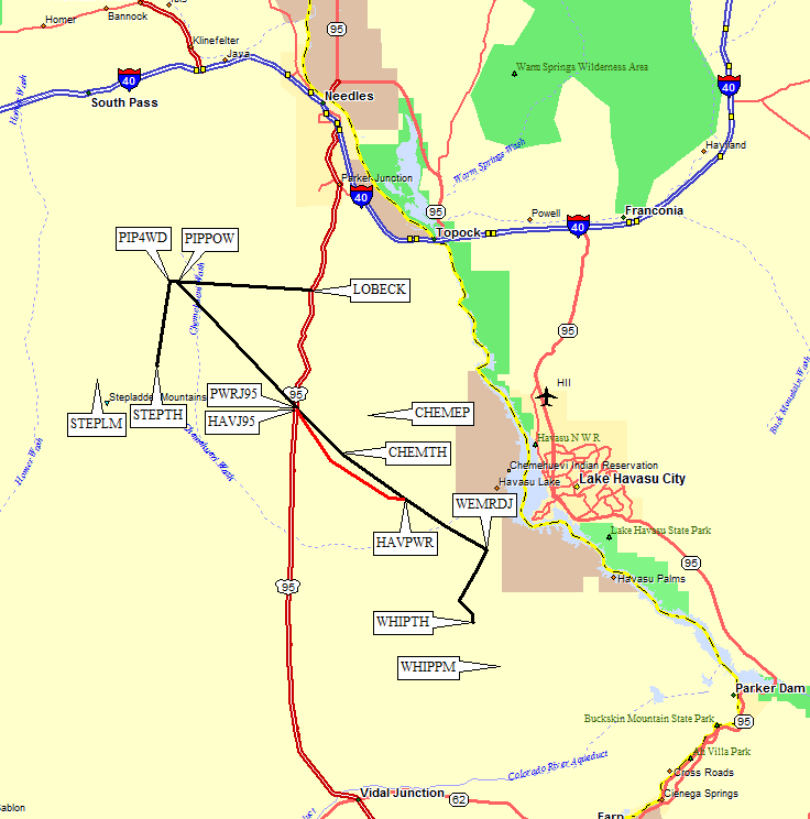
Leave US Hwy 95 by turning west on either the pipeline maintenance road
at Lobeck Pass (waypoint LOBECK), or on the powerline maintenance road
near Havasu Lake Road (waypoint PWRJ95). The powerline is 45mph quality,
the pipeline is 25mph with hard braking for erosion humps and washouts,
and you'll need to bear slightly left at a big solar panel installation
(waypoint PIPPGE). Both roads are fine for passenger cars.
Drive to the intersection of these two roads (waypoint PIPPOW), which is
about 9 miles on the pipeline road or 11 miles on the powerline road.
Continue half a mile west to where a flat sandy wash crosses the road
(waypoint PIP4WD). The road crews have built a tall berm beside the
powerline road to channel water into this wash, and in so doing they
have hidden the 4WD road you want! Turn south into the wash for no
more than 50 feet, then turn west along the berm for 100 feet, then
turn south again on the 4WD road that will take you directly to the
trailhead. You cannot see this turnoff or the 4WD road from the
pipeline road!
The 4WD road is very narrow and rutted with erosion gullies. You will
need high clearance and you will scratch your vehicle. You won't need 4WD.
The DPS Guide does not describe this trailhead well. There are stakes
marking the wilderness boundary at waypoint STEPTH, well beyond the
mileage indicated by the DPS. When we were there in 2009, there were
tracks around the stakes. We stopped anyway. The DPS Guide says to
continue walking south on the road, which takes you downhill and
does two sides of a triangle. We found it worked better to walk
straight to the entrance of the valley used to approach the peak,
as indicated by these waypoints.
It's open terrain with no obstacles. Be sure to mark your vehicle's
location with a GPS or take some really good bearings, because
you'll be walking around a broad alluvial fan that blocks your view.
Chemehuevi is approached via the powerline maintenance road, but
what the DPS Guide won't tell you is that there are TWO places
you can get on this fine high-speed dirt road. The west approach
starts immediately north of the Havasu Lake Road where the
powerline crosses US Hwy 95 (waypoint PWRJ95). The east approach
is where the powerline crosses Havasu Lake Road (waypoint HAVPWR)
about 10 miles southeast of US Hwy 95. If you're doing Whipple
also, just stay on the powerline road and do Chemehuevi on the way.
Both approaches are fine for passenger cars.
About 4 miles from US Hwy 95, the powerline road crosses under
the powerlines proper (waypoint CHEMTH, near USGS BM 1689). There
is a slight wash here, and you can drive into it on the south side
of the road to park. The north side is staked as wilderness.
It's a fairly quiet place to spend the night, with the bonus of
cell phone reception.
There is a more obvious parking place just under half a mile
southeast, but you'll have more up-and-down climbing from there.
Stay left of most of the small bumps, but be careful not to drift
too far left or you'll end up in the wrong canyon. Enjoy the
cholla cactus! When returning to your car, you can navigate by
steering left of the dark bump labelled Rotten (1800') on the
USGS topo maps - it's on the other side of the road, but it's
identifiable from almost everywhere on the way down.
Whiple is approached via the powerline maintenance road, but
what the DPS Guide won't tell you is that there are TWO places
you can get on this fine high-speed dirt road. The fast approach
starts where the Havasu Lake Road ends at US Hwy 95 (waypoint HAVJ95).
If you're doing Chemehuevi also, you can take the powerline road
all the way from US Hwy 95 (waypoint PWRJ95). Either way, find the
place where the powerline crosses Havasu Lake Road (waypoint HAVPWR)
about 10 miles southeast of US Hwy 95.
Both approaches are fine for passenger cars.
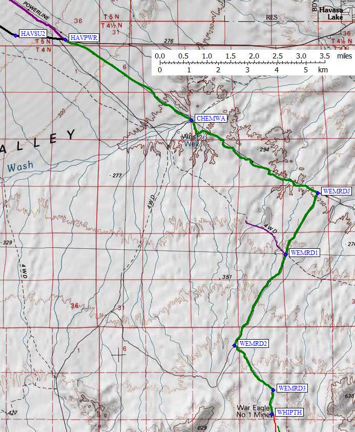
From waypoint HAVPWR, follow the powerline road southeast just
over 3 miles to the Chemehuevi Wash (waypoint CHEMWA). This wide
and deep drainage has tracks leading down the wash, but stay on
the powerline road as it climbs directly out the other side of
the wash. We investigated the 4WD road which parallels the powerline
road, and found it was too washed out for travel (although it would
be a fun place to play if you can get yourself unstuck).
Continue southeast about 3.5 miles, through increasingly hilly terrain,
until you come to an unmarked and easily missed junction with the
War Eagle Mine Road (waypoint WEMRDJ). Turn southwest on this poor
dirt road which leads to the War Eagle Mine. Cross the road at
WEMRD1 (which we only got a mile on when we tried it) and go straight
for almost 4 miles from the powerline road. At waypoint WEMRD2 turn
left into a side canyon, and at WEMRD3 stay right as the road gets
steeper and more winding.
You can drive past the old War Eagle Mine ruins at waypoint WHIPTH,
but it doesn't help any. You'll need to drop into the wash
to your left for the best walking, rather than staying on
on the road's ridge. This trailhead seems remote, but you
can see the city lights from here. There are lots of burros
in the area, which we both saw and heard.
Useful Links:
Stepladder Mtn
Chemehuevi Peak
Whipple Mtn
Detailed Whipple Map, see also area map above:
Labels here, and on the overall map above, are in the waypoint file.