Water Dog Lake - SF Bay Area
Revised Jan 2005 - please send updates to the webmaster
This seems like a small park, but it's surprisingly isolated and has a wide variety of trails honeycombed into steep hills with trees and brush. Mountain bikes are allowed on all trails except Sheep Camp Trail, which isn't really part of Water Dog Lake Park... but then again some of the other trails appear to go out of the official park boundary also.
Water Dog Lake itself is really a small flood control pond, which can be viewed from the Dam Trail, the High Trail, and the Lake Trail. Trailhead signs are vague and trail junctions are entirely unmarked. I just made up these trail names because I needed to organize things in my head. You won't find the trail names anywhere else. By the way, some places call it Waterdog, but the USGS calls it Water Dog (two words).
Click here for:
These trail names match route names in the waypoint file, and each has a more detailed map and description below:
Since it's in the middle of a residential area, there are many unofficial
access points along with the signed (official) trailheads. Most people
will exit Hwy 92 at Ralston, and head west all the way down the hill.
The Hallmark Drive trailhead (waypoint HALMRK) is just south of Ralston,
the Lyall Way trailhead (waypoint LYALLW) is also south of Ralston but
requires doubling back a bit to the west (at the intersection of Lyall Way
and Lake Road). If you turn south off Lyall Way at Lake Road and follow
Lake around the corner where it becomes Carlmont Drive, then follow
Carlmont to a dead end, you'll find the Carlmont trailhead (waypoint CRLEND).
The other entrances are unofficial.
Look for them on or near Hastings, Club, Crestview, and Hallmark.
Belmont installed a roadblock to keep San Carlos residents out
(waypoint RDBLCK) so Crestview Dr no longer connects to Hallmark Dr
as far as cars are concerned. There are a couple of use trails leading
down from bark-chip landscaped areas (like CRESTS and CRESTN) but no
good trailheads near the roadblock.
If you can find parking, there are a couple of access points along
Somerset Dr (take Leigh or Wakefield off Hallmark, to waypoints
SOMRSE and SOMRNW) which have the best views
(waypoint SOMRSE is the best, but SOMRNW
has a use trail down to a hidden bench) for the shortest walk.
The trail access points are somewhat hidden by fences, but are official right-of-ways.
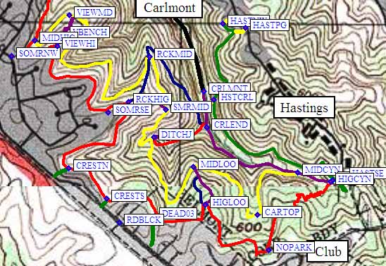
Over on Hastings, however, there are several good (but unmarked) trailheads
at waypoints HASTSE (near an electrical box) and HASTNW (at the end of
Ridgewood Ct, just off Hastings near a playground). Just park on the street
and notice that no signs limit you to sunlight hours here (as the official
entry points do).
The Sheep Camp Trail (a county trail) connects to Water Dog at the
Hallmark Drive trailhead (waypoint HALMRK) where there is no sign
but you can find a trail just north of the pump building. That trail
leads to a signed crossing of Saint James Road (waypoint STJAME),
and Sheep Camp continues down under the I-280 freeway at a vista
point exit. There is NO PARKING anywhere near the Sheep Camp trail,
but you can drive up to the vista point (waypoints VISTAJ and VISTAP)
and walk back down to the trail. Sheep Camp Trail then continues south
to Canada Road at waypoint CANADA, where there is a small parking
area and a sign that says no bicycles are allowed (unlike the other
end, at VISTAJ, which has no such sign). The character of this trail
is boring and noisy, unlike Water Dog Lake trails.
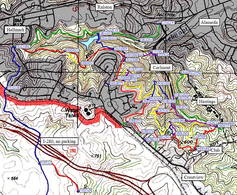
This is the old road north of Water Dog Lake, connecting
trailheads at Hallmark Drive (waypoint HALMRK, uphill to
the west) and Lyall Way (waypoint LYALLW, downhill to the east).
It's the easiest trail of all - road width and low slope the whole way.
The Dam Trail goes south past the lake
from the middle of the Lake Trail. Other apparent trail
junctions dead-end in brush and poison oak.
Connects the Lake Trail (at waypoint DAMLAK)
and the High Trail (at waypoints DAMHIE or DAMHIW)
by going across the dam (waypoint DAMDAM) at the east end of Water Dog Lake.
It is very steep for a short bit just south of the lake,
then levels off and almost touches High Trail
(at waypoint DAMHIW) but continues west until it intersects
the Condo Trail (waypoint CONDAM) and finally
ends at a place where the High Trail drops a bit
(waypoint DAMHIE).
Connects the High Trail (waypoint CONHIG)
and the Dam Trail (waypoint CONDAM) to
the parking lot of the condo at 2510 Carlmont Drive
(waypoints 2510PL and 2510CD). It's a steep, narrow,
unauthorized trail with bad footing near the bottom.
Eastern portion:
Connects from the Hallmark Drive trailhead (waypoint HALMRK)
to the Canyon Trail (at waypoint HIGCYN), staying as high as
possible on the southwest side of the park the entire way.
This is the place to be if you like long views across the bay.
By far the best view from the entire trail system is at waypoint VIEWHI.
Also, look for the old "No Parking" sign
(at waypoint NOPARK) which dates from the days when
this area was a tourist destination - a huge tree has
literally engulfed the sign's post over many years.
Some road-width, some single-track, this is the most
poison-oak-free trail other than the Lake Trail.
There are numerous connectors to the Middle Trail,
Rocky Road, View Trail, and Dam Trail in addition
to many access points at unofficial trailheads.
Connects the High Trail (at waypoint MIDHIG, just south of Dam Trail)
to the Canyon Trail (at waypoint MIDCYN, just west of where
the Canyon Trail intersects that High Trail).
The western end of Middle Trail (waypoint MIDHIG) is a 3-way
junction in a grove of Bay Trees. Take the lower trail from either
direction of the High Trail to get to Middle Trail (lowest of the
three triangle points).
It is almost all single track, sometimes slopes sideways,
and has the highest risk of poison oak. It also has a cool
bridge across the top of a buried car (waypoint CARTOP).
Connects the best viewpoint on the High Trail (waypoint VIEWHI)
with the Middle Trail (waypoint VIEWMD) by way of a poor use
trail that goes past a secluded bench (waypoint VBENCH).
This is not an official trail, and there are many indistinct
use trails that could be confused with it.
This is the shortest connection from the Carlmont Trailhead
(waypoint CRLMNT) to the High Trail (at waypoint RCKHIG).
It is steep and (surprise!) rocky at the top.
If you want to do short steep 15-minute laps, combine
Rocky Road with the Ditch Trail and part of the Middle Trail,
connecting waypoints CRLEND, DITCHJ, SMRMID, RCKHIG, RCKMID,
and back to CRLEND.
Rocky Road and the Somerset Trail form a triangle of
intersections between the High Trail and the Middle Trail
(RCKHIG near SOMRSE to either RCKMID or to SMRMID).
Connects from the High Trail (waypoint RCKHIG, near the
SOMRSE access point) to the Middle Trail (waypoint SMRMID),
forming the south side of a triangle with Rocky Road and the Middle Trail.
From the lower end parking (waypoint CRLMNT) to the upper end where
it hits the High Trail (waypoint HIGCYN), this is a narrow overgrown
unmaintained trail.
The only reason to take it is to reach the eastern end of the
Middle Trail (at waypoint MIDCYN). Otherwise the Hastings Trail
is more pleasant.
This is a fire-road-width trail from the end of short
side-road Ridgewood Ct (waypoint HASTNW) or a tiny
playground (waypoint HASTPG) down to Carlmont Trailhead
(waypoint CRLEND, just up-canyon from the parking lot
at waypoint CRLMNT), or down and up to High Trail
(waypoint HIGCYN), or all the way back up to an unmarked
access point on Hastings (waypoint HASTSE, near a large
electrical box, behind a lamppost).
There are other single track unofficial access points
in the area, some of which cross grassy empty lots to
connect to Hastings, but the correct trail stays wide and level.
There are junctions to both ends of the Canyon Trail
and the east end of the High Trail.
A short steep connector between the Carlmont trailhead
(waypoint CRLEND, just up-canyon from the parking lot
at waypoint CRLMNT), and the Middle Trail (at waypoint DITCHJ).
The west end of the trail splits into a branch that follows
the ditch and a branch that loops to the south, but the
split is short and the trails converge clearly at both ends.
The branch that follows the ditch is eroding and may
collapse, the other branch is steep and slick. Both
problem spots are very short.
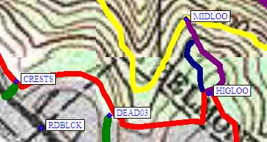
Connects the High Trail (at waypoint HIGLOO) to the
Middle Trail (at waypoint MIDLOO) with two options that
go the same place. The eastern path is in good shape,
the western path is deeply eroded and somewhat overgrown.
Useful Links:
Trailheads - places to park and access points
(both official and unofficial)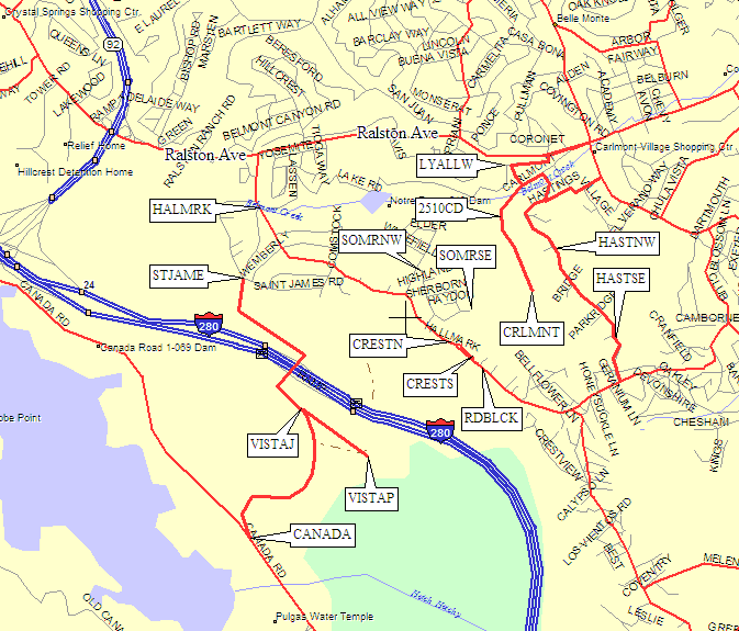
Lake Trail: 1.4 mi green line on the map below
(a dirt road north of Water Dog Lake)
Dam Trail: 0.4 mi blue line on the map below
(goes across the dam, connects High and Lake trails)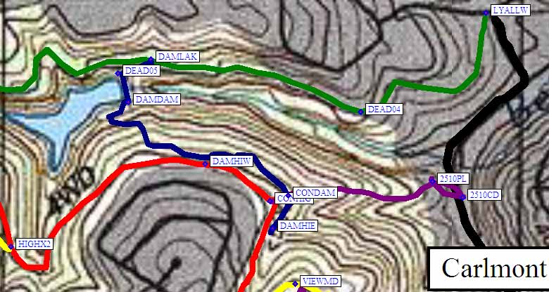
Condo Trail: 0.3 mi purple line on the map below
(use trail down to a condo on Carlmont Dr)
High Trail: 3 mi red line on the map below
Western portion:
(stays as high as possible, on the SW side)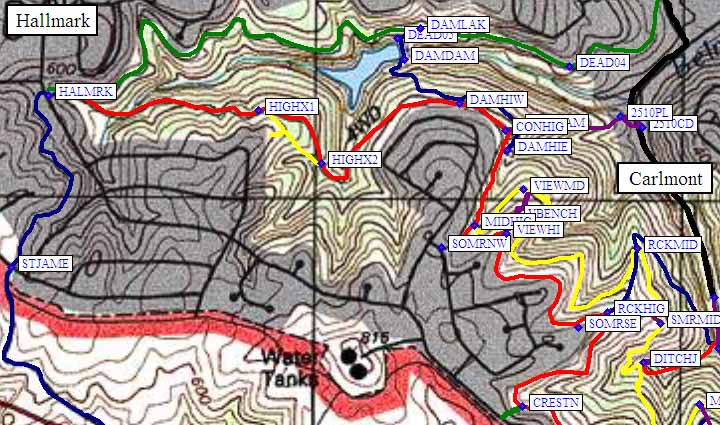
Middle Trail: 1.8 mi yellow line on the map below
(parallels the eastern half of the High Trail)
View Trail: 0.3 mi purple trail on the map below
(connects the High and Middle trails via a bench)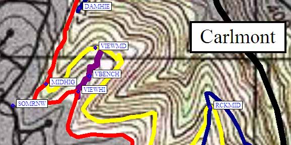
Rocky Road: 0.4 mi blue line on the map below
(from Carlmont trailhead to High Trail, all uphill)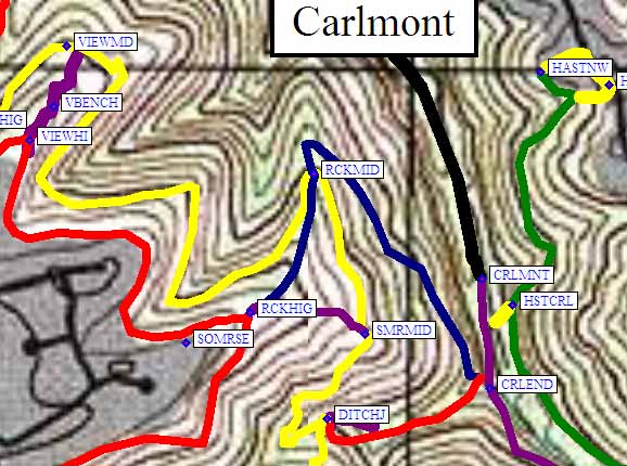
Somerset Trail: 0.1 mi purple line at the middle of the map below
(connects the High and Middle trails)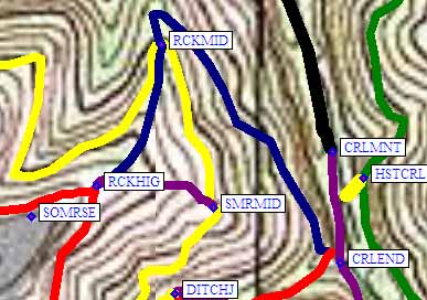
Canyon Trail: 0.5 mi purple line in the middle of the map below
(where Carlmont Dr would go if it didn't end)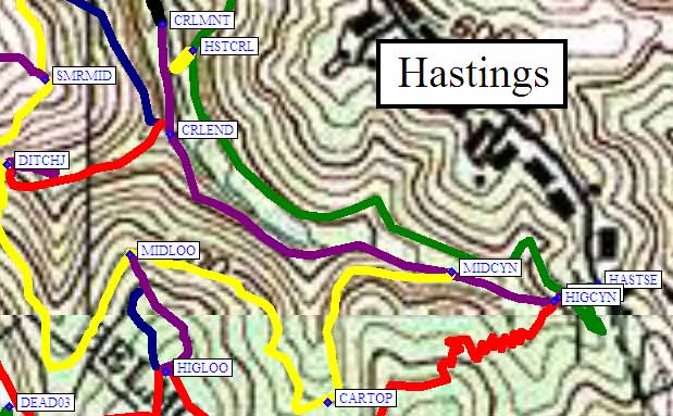
Hastings Trail: 0.8 mi green line on the map below
connects Hastings to Carlmont)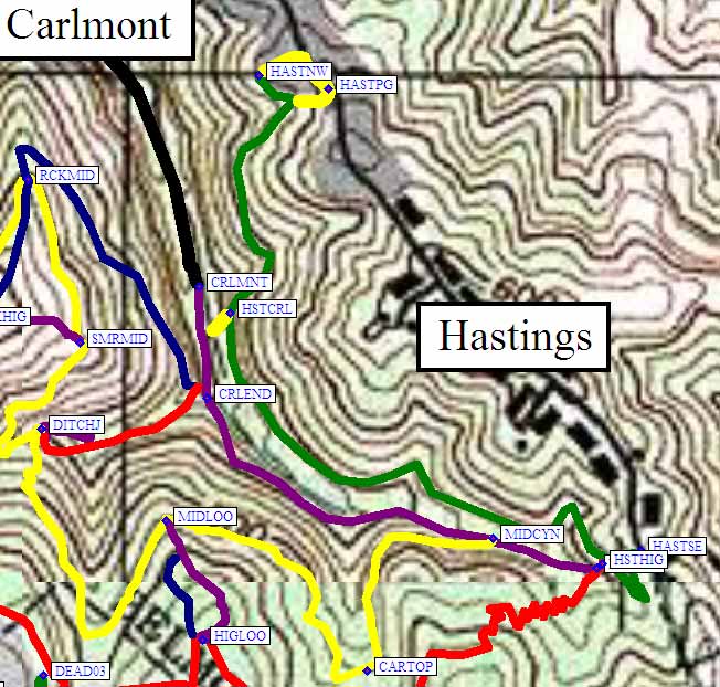
Ditch Trail: 0.1 mi red line on the map below
connects Carlmont to the Middle Trail)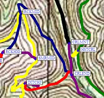
Loop Trail: 0.1 mi purple and blue lines on the map below
two connectors between High and Middle trails)